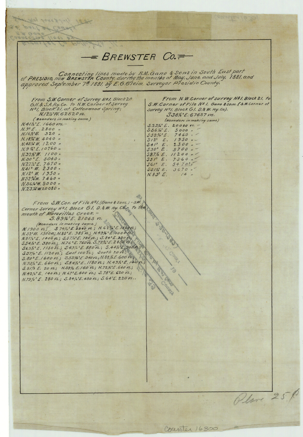
Brewster County Sketch File 39
Connecting lines made by R.M. Gano & Sons in south east part of Presidio, now Brewster County, during the months of May, June and July, 1881, and approved September 7th, 1881 by E.G. Glein, surveyor, Presidio County
-
Map/Doc
16300
-
Collection
General Map Collection
-
Object Dates
1881 (Survey Date)
-
People and Organizations
E.G. Glein (Surveyor/Engineer)
R.M. Gano (Surveyor/Engineer)
-
Counties
Brewster
-
Subjects
Surveying Sketch File
-
Height x Width
12.8 x 8.9 inches
32.5 x 22.6 cm
-
Medium
linen, manuscript
-
Features
Cottonwood Spring
Maravillas Creek
Part of: General Map Collection
Moore County Sketch File 13

Print $24.00
- Digital $50.00
Moore County Sketch File 13
1919
Size 7.0 x 8.7 inches
Map/Doc 31949
Webb County Sketch File 13b

Print $3.00
- Digital $50.00
Webb County Sketch File 13b
1893
Size 14.0 x 9.8 inches
Map/Doc 39803
Eastland County Working Sketch 30

Print $20.00
- Digital $50.00
Eastland County Working Sketch 30
1954
Size 20.2 x 24.0 inches
Map/Doc 68811
Flight Mission No. BQR-5K, Frame 71, Brazoria County

Print $20.00
- Digital $50.00
Flight Mission No. BQR-5K, Frame 71, Brazoria County
1952
Size 18.8 x 22.4 inches
Map/Doc 84016
Blanco County Working Sketch 30

Print $20.00
- Digital $50.00
Blanco County Working Sketch 30
1971
Size 22.9 x 34.6 inches
Map/Doc 67390
Hunt County Boundary File 9

Print $64.00
- Digital $50.00
Hunt County Boundary File 9
Size 8.9 x 8.9 inches
Map/Doc 55241
Coast Chart No. 210 Aransas Pass and Corpus Christi Bay with the coast to latitude 27° 12' Texas

Print $20.00
- Digital $50.00
Coast Chart No. 210 Aransas Pass and Corpus Christi Bay with the coast to latitude 27° 12' Texas
1887
Size 27.5 x 18.3 inches
Map/Doc 72787
Right of Way and Track Map, St. Louis, Brownsville & Mexico Railway operated by St. Louis Brownsville & Mexico Ry. Co., Jefferson Lake Oil Company

Print $40.00
- Digital $50.00
Right of Way and Track Map, St. Louis, Brownsville & Mexico Railway operated by St. Louis Brownsville & Mexico Ry. Co., Jefferson Lake Oil Company
1937
Size 25.3 x 57.1 inches
Map/Doc 64612
Map of Runnels County

Print $20.00
- Digital $50.00
Map of Runnels County
1898
Size 43.2 x 36.9 inches
Map/Doc 16803
Blanco County Boundary File 8

Print $20.00
- Digital $50.00
Blanco County Boundary File 8
Size 20.1 x 11.1 inches
Map/Doc 50575
Liberty County Working Sketch 16

Print $20.00
- Digital $50.00
Liberty County Working Sketch 16
1936
Size 24.1 x 34.7 inches
Map/Doc 70475
Anderson County Sketch File 27

Print $40.00
- Digital $50.00
Anderson County Sketch File 27
1970
Size 19.5 x 23.7 inches
Map/Doc 10806
You may also like
Andrews County Rolled Sketch 29

Print $20.00
- Digital $50.00
Andrews County Rolled Sketch 29
1949
Size 36.6 x 16.3 inches
Map/Doc 77173
Edwards County Working Sketch 16

Print $20.00
- Digital $50.00
Edwards County Working Sketch 16
1929
Size 21.5 x 21.5 inches
Map/Doc 68892
Travis County Working Sketch 64

Print $4.00
- Digital $50.00
Travis County Working Sketch 64
Size 16.8 x 19.6 inches
Map/Doc 69448
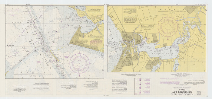
Nautical Chart 152-SC - Galveston Bay, Texas
Print $20.00
- Digital $50.00
Nautical Chart 152-SC - Galveston Bay, Texas
1972
Size 15.5 x 33.2 inches
Map/Doc 69890
Eastham Farm, Texas Prison System, Houston County

Print $20.00
- Digital $50.00
Eastham Farm, Texas Prison System, Houston County
Size 17.3 x 18.4 inches
Map/Doc 62988
Bosque County Working Sketch 20

Print $20.00
- Digital $50.00
Bosque County Working Sketch 20
1976
Size 37.4 x 32.8 inches
Map/Doc 67453
Texas Official Travel Map

Digital $50.00
Texas Official Travel Map
Size 33.3 x 36.2 inches
Map/Doc 94302
Panola County Working Sketch 30

Print $20.00
- Digital $50.00
Panola County Working Sketch 30
1981
Map/Doc 71439
Flight Mission No. DCL-6C, Frame 54, Kenedy County

Print $20.00
- Digital $50.00
Flight Mission No. DCL-6C, Frame 54, Kenedy County
1943
Size 18.6 x 22.4 inches
Map/Doc 85896
Somervell County Working Sketch 6

Print $20.00
- Digital $50.00
Somervell County Working Sketch 6
Size 23.2 x 21.5 inches
Map/Doc 63910
[Atlas C, Table of Contents]
![78353, [Atlas C, Table of Contents], General Map Collection](https://historictexasmaps.com/wmedia_w700/maps/78353.tif.jpg)
Print $3.00
- Digital $50.00
[Atlas C, Table of Contents]
Size 14.7 x 9.6 inches
Map/Doc 78353
Bailey County Working Sketch 4

Print $20.00
- Digital $50.00
Bailey County Working Sketch 4
1937
Size 27.0 x 32.0 inches
Map/Doc 67591