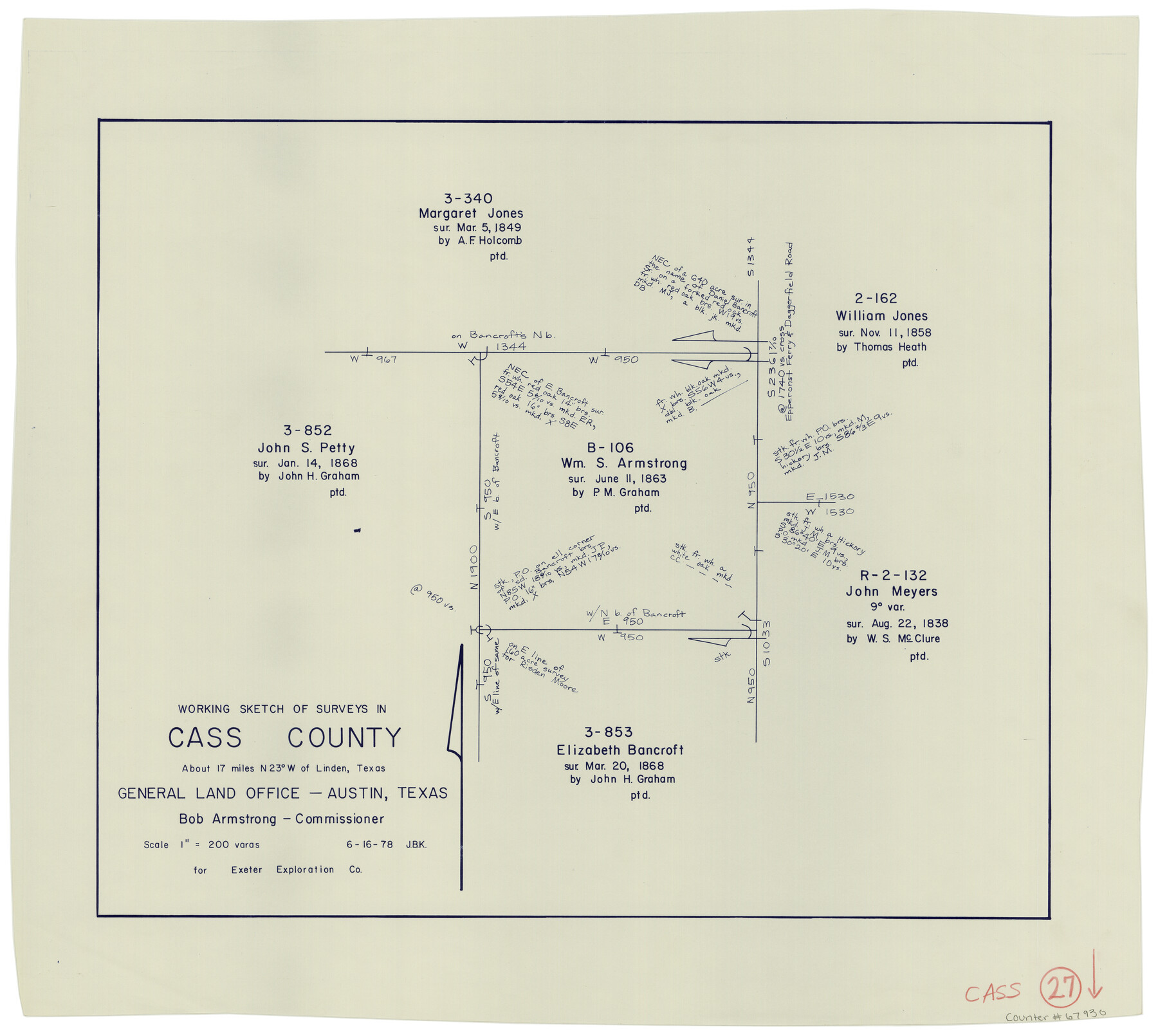
Cass County Working Sketch 27
-
Map/Doc
67930
-
Collection
General Map Collection
-
Object Dates
6/16/1978 (Creation Date)
-
People and Organizations
Joan Kilpatrick (Draftsman)
-
Counties
Cass
-
Subjects
Surveying Working Sketch
-
Height x Width
17.5 x 19.7 inches
44.5 x 50.0 cm
-
Scale
1" = 200 varas
Part of: General Map Collection
Map of Young County

Print $20.00
- Digital $50.00
Map of Young County
1897
Size 44.1 x 37.9 inches
Map/Doc 63140
Flight Mission No. DAG-21K, Frame 90, Matagorda County

Print $20.00
- Digital $50.00
Flight Mission No. DAG-21K, Frame 90, Matagorda County
1952
Size 18.5 x 22.2 inches
Map/Doc 86419
Lavaca County Sketch File 8

Print $6.00
- Digital $50.00
Lavaca County Sketch File 8
1882
Size 10.7 x 10.3 inches
Map/Doc 29644
Topographical Map of the Rio Grande, Sheet No. 15

Print $20.00
- Digital $50.00
Topographical Map of the Rio Grande, Sheet No. 15
1912
Map/Doc 89539
Pecos County Working Sketch 10

Print $20.00
- Digital $50.00
Pecos County Working Sketch 10
1907
Size 25.9 x 23.9 inches
Map/Doc 71480
Dimmit County

Print $40.00
- Digital $50.00
Dimmit County
1916
Size 40.6 x 48.0 inches
Map/Doc 78341
Right of Way and Track Map International & Gt. Northern Ry. operated by the International & Gt. Northern Ry. Co., Columbia Branch, Gulf Division

Print $40.00
- Digital $50.00
Right of Way and Track Map International & Gt. Northern Ry. operated by the International & Gt. Northern Ry. Co., Columbia Branch, Gulf Division
1917
Size 25.1 x 56.4 inches
Map/Doc 64596
Henderson County Sketch File 22

Print $14.00
- Digital $50.00
Henderson County Sketch File 22
1942
Size 14.2 x 8.9 inches
Map/Doc 26365
Shelby County Working Sketch 33

Print $20.00
- Digital $50.00
Shelby County Working Sketch 33
2008
Size 23.6 x 27.5 inches
Map/Doc 88886
Harrison County Rolled Sketch 15

Print $20.00
- Digital $50.00
Harrison County Rolled Sketch 15
2008
Size 20.5 x 21.0 inches
Map/Doc 89045
Hockley County Sketch File 10

Print $6.00
- Digital $50.00
Hockley County Sketch File 10
1921
Size 11.2 x 8.8 inches
Map/Doc 26541
Map of Wise County Texas

Print $20.00
- Digital $50.00
Map of Wise County Texas
1912
Size 31.3 x 28.8 inches
Map/Doc 4644
You may also like
Flight Mission No. CRK-5P, Frame 130, Refugio County

Print $20.00
- Digital $50.00
Flight Mission No. CRK-5P, Frame 130, Refugio County
1956
Size 18.6 x 22.5 inches
Map/Doc 86933
Lampasas County Boundary File 2

Print $4.00
- Digital $50.00
Lampasas County Boundary File 2
Size 13.8 x 8.8 inches
Map/Doc 56095
Polk County Rolled Sketch 32

Print $20.00
- Digital $50.00
Polk County Rolled Sketch 32
Size 21.6 x 15.8 inches
Map/Doc 7318
Harris County Rolled Sketch 89

Print $20.00
- Digital $50.00
Harris County Rolled Sketch 89
1899
Size 22.1 x 35.3 inches
Map/Doc 6128
Medina County Sketch File 8

Print $4.00
- Digital $50.00
Medina County Sketch File 8
Size 9.3 x 6.6 inches
Map/Doc 31456
McLennan County Working Sketch 3

Print $20.00
- Digital $50.00
McLennan County Working Sketch 3
1941
Size 18.0 x 17.9 inches
Map/Doc 70696
Concho County Working Sketch 9

Print $20.00
- Digital $50.00
Concho County Working Sketch 9
1950
Size 20.0 x 14.6 inches
Map/Doc 68191
Hamilton County Working Sketch 3

Print $20.00
- Digital $50.00
Hamilton County Working Sketch 3
1926
Size 29.6 x 39.6 inches
Map/Doc 63341
Hood County Working Sketch 9

Print $20.00
- Digital $50.00
Hood County Working Sketch 9
1972
Size 28.0 x 31.7 inches
Map/Doc 66203
Gillespie County Sketch File 2

Print $40.00
- Digital $50.00
Gillespie County Sketch File 2
1847
Size 12.8 x 15.5 inches
Map/Doc 24127
Kimble County Rolled Sketch 37

Print $20.00
- Digital $50.00
Kimble County Rolled Sketch 37
1982
Size 21.6 x 28.0 inches
Map/Doc 6527
South Part Brewster Co.

Print $40.00
- Digital $50.00
South Part Brewster Co.
1910
Size 32.0 x 49.7 inches
Map/Doc 66728