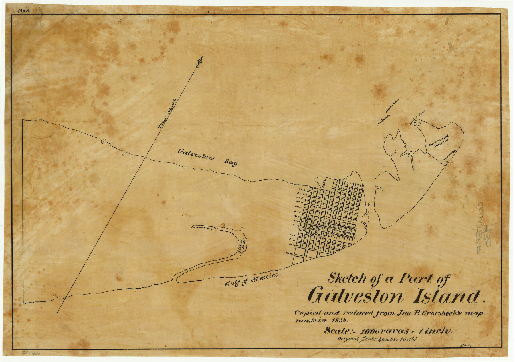
Sketch of a part of Galveston Island
-
Map/Doc
430
-
Collection
Maddox Collection
-
People and Organizations
Maxcy (Draftsman)
-
Counties
Galveston
-
Subjects
Gulf of Mexico
-
Height x Width
10.8 x 13.8 inches
27.4 x 35.1 cm
-
Medium
paper, manuscript
-
Scale
1000 varas = 1 inch
-
Comments
Copied and reduced from Jno. P. Groesbeck's map made in 1838.
-
Features
Galveston
Gulf of Mexico
Bakers Bayou
Galveston Bay
Old Fort
Pilot House
Quarantine
Broadway
Part of: Maddox Collection
Sketch H, Dickens County, Texas

Print $20.00
- Digital $50.00
Sketch H, Dickens County, Texas
1902
Size 16.0 x 14.3 inches
Map/Doc 4365
Wichita County

Print $20.00
- Digital $50.00
Wichita County
1892
Size 20.2 x 24.3 inches
Map/Doc 75804
Survey 4, Block 1, D.B. Gardner

Print $20.00
- Digital $50.00
Survey 4, Block 1, D.B. Gardner
1914
Size 26.6 x 13.7 inches
Map/Doc 10769
Picturesque Glen Ridge, A Beautiful Suburb of Austin

Print $20.00
- Digital $50.00
Picturesque Glen Ridge, A Beautiful Suburb of Austin
1890
Size 28.9 x 40.9 inches
Map/Doc 584
Sketch in Atascosa County

Print $3.00
- Digital $50.00
Sketch in Atascosa County
1890
Size 12.6 x 11.4 inches
Map/Doc 578
Map of part of Presidio Co. Texas

Print $20.00
- Digital $50.00
Map of part of Presidio Co. Texas
Size 16.5 x 21.3 inches
Map/Doc 75769
Map of survey made for Ingham S. Roberts on Application No. 147, SF-9177 containing 413.78 acres, 4 mi SE of Houston, Harris Co. Texas

Print $20.00
- Digital $50.00
Map of survey made for Ingham S. Roberts on Application No. 147, SF-9177 containing 413.78 acres, 4 mi SE of Houston, Harris Co. Texas
1910
Size 37.3 x 31.0 inches
Map/Doc 373
[George Tenille Grant, Brazoria County, Texas]
![10751, [George Tenille Grant, Brazoria County, Texas], Maddox Collection](https://historictexasmaps.com/wmedia_w700/maps/10751.tif.jpg)
Print $2.00
- Digital $50.00
[George Tenille Grant, Brazoria County, Texas]
Size 11.2 x 9.2 inches
Map/Doc 10751
Map of Bandera County, Texas

Print $20.00
- Digital $50.00
Map of Bandera County, Texas
1879
Size 19.6 x 32.6 inches
Map/Doc 691
Hansford County, Texas

Print $20.00
- Digital $50.00
Hansford County, Texas
1888
Size 22.6 x 18.6 inches
Map/Doc 5033
Map of surveys 189 & 190, T. C. R.R. Co. in Travis County, Texas

Print $20.00
- Digital $50.00
Map of surveys 189 & 190, T. C. R.R. Co. in Travis County, Texas
1915
Size 16.3 x 23.5 inches
Map/Doc 75762
Map of Kinney County, Texas

Print $20.00
- Digital $50.00
Map of Kinney County, Texas
1879
Size 21.2 x 33.1 inches
Map/Doc 548
You may also like
Ochiltree County Sketch File 12

Print $24.00
- Digital $50.00
Ochiltree County Sketch File 12
1990
Size 11.2 x 8.5 inches
Map/Doc 33201
General Highway Map, Navarro County, Texas

Print $20.00
General Highway Map, Navarro County, Texas
1939
Size 24.6 x 18.5 inches
Map/Doc 79207
Presidio County Rolled Sketch 131A

Print $3.00
- Digital $50.00
Presidio County Rolled Sketch 131A
Size 14.5 x 9.1 inches
Map/Doc 10709
Cameron County Rolled Sketch 29

Print $20.00
- Digital $50.00
Cameron County Rolled Sketch 29
1990
Size 29.3 x 46.4 inches
Map/Doc 8578
Wise County Working Sketch 6

Print $20.00
- Digital $50.00
Wise County Working Sketch 6
1950
Size 12.0 x 15.2 inches
Map/Doc 72620
Dimmit County Sketch File 8

Print $20.00
- Digital $50.00
Dimmit County Sketch File 8
1875
Size 18.2 x 29.1 inches
Map/Doc 11337
Hall County Working Sketch Graphic Index

Print $20.00
- Digital $50.00
Hall County Working Sketch Graphic Index
1972
Size 41.7 x 33.7 inches
Map/Doc 76563
Pecos County Rolled Sketch 78

Print $40.00
- Digital $50.00
Pecos County Rolled Sketch 78
1930
Size 52.6 x 44.1 inches
Map/Doc 9705
Map of Comanche County

Print $40.00
- Digital $50.00
Map of Comanche County
1895
Size 47.5 x 50.0 inches
Map/Doc 4735
Trinity County Working Sketch 13

Print $20.00
- Digital $50.00
Trinity County Working Sketch 13
1956
Size 18.2 x 24.7 inches
Map/Doc 69462
[Township 5-S, Blocks 36, 37 & 38]
![92291, [Township 5-S, Blocks 36, 37 & 38], Twichell Survey Records](https://historictexasmaps.com/wmedia_w700/maps/92291-1.tif.jpg)
Print $20.00
- Digital $50.00
[Township 5-S, Blocks 36, 37 & 38]
1952
Size 27.6 x 26.5 inches
Map/Doc 92291
Marion County Working Sketch Graphic Index, Sheet 1 (Sketches 1 to 26)

Print $20.00
- Digital $50.00
Marion County Working Sketch Graphic Index, Sheet 1 (Sketches 1 to 26)
1943
Size 26.8 x 45.1 inches
Map/Doc 76629