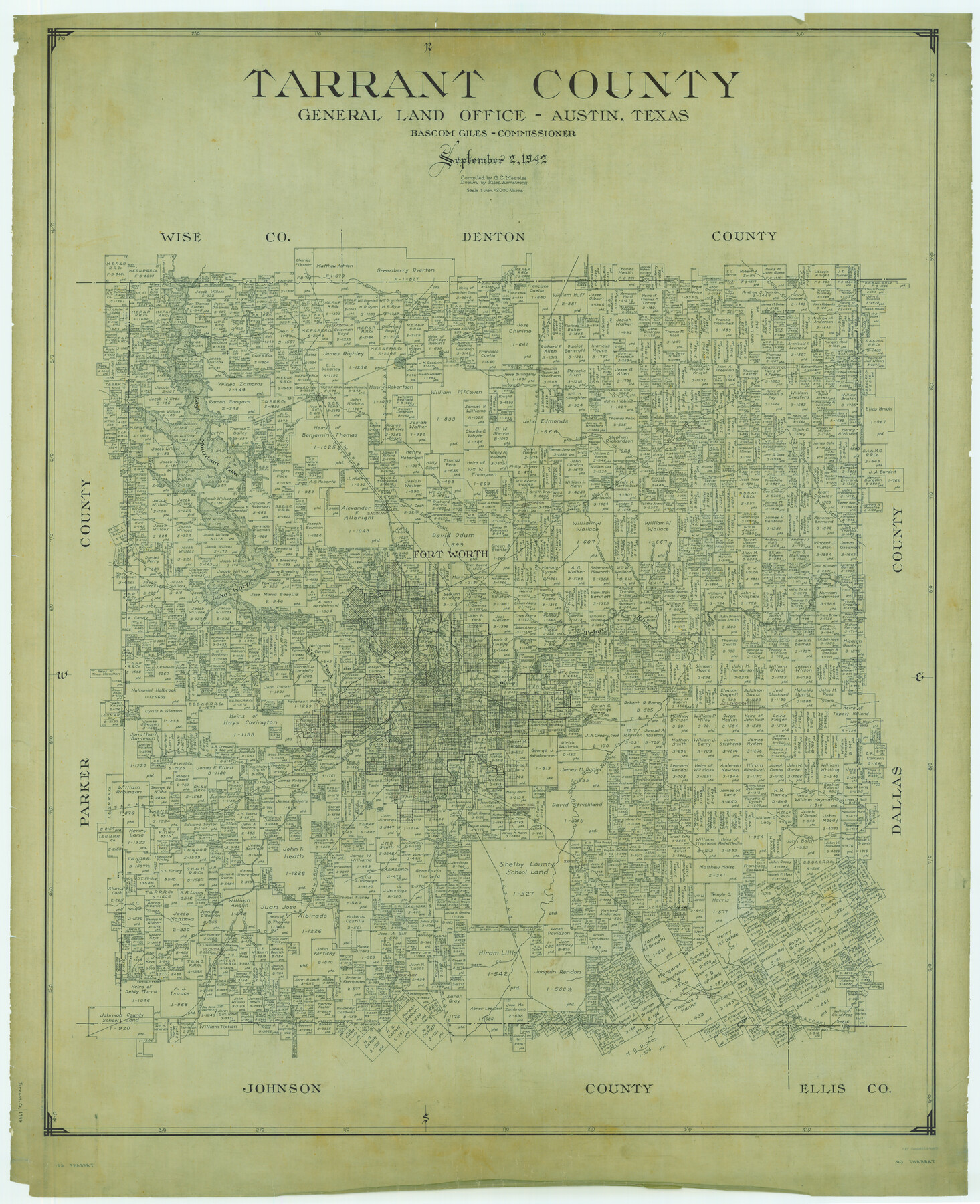
Tarrant County
-
Map/Doc
63057
-
Collection
General Map Collection
-
Object Dates
1942/9/2 (Creation Date)
-
People and Organizations
Texas General Land Office (Publisher)
Eltea Armstrong (Draftsman)
Bascom Giles (GLO Commissioner)
G.C. Morriss (Compiler)
-
Counties
Tarrant
-
Subjects
County
-
Height x Width
46.7 x 38.0 inches
118.6 x 96.5 cm
Part of: General Map Collection
Hardin County Rolled Sketch 21

Print $20.00
- Digital $50.00
Hardin County Rolled Sketch 21
1966
Size 18.8 x 22.7 inches
Map/Doc 6090
Flight Mission No. BRE-2P, Frame 17, Nueces County

Print $20.00
- Digital $50.00
Flight Mission No. BRE-2P, Frame 17, Nueces County
1956
Size 18.2 x 22.1 inches
Map/Doc 86726
Flight Mission No. DQN-1K, Frame 78, Calhoun County

Print $20.00
- Digital $50.00
Flight Mission No. DQN-1K, Frame 78, Calhoun County
1953
Size 18.5 x 22.1 inches
Map/Doc 84163
Crane County Rolled Sketch 2

Print $40.00
- Digital $50.00
Crane County Rolled Sketch 2
1888
Size 55.3 x 29.0 inches
Map/Doc 8676
Wichita County Rolled Sketch 5

Print $20.00
- Digital $50.00
Wichita County Rolled Sketch 5
Size 24.1 x 39.2 inches
Map/Doc 8242
Bandera County Working Sketch Graphic Index

Print $40.00
- Digital $50.00
Bandera County Working Sketch Graphic Index
1947
Size 33.5 x 53.8 inches
Map/Doc 76461
Foard County Sketch File XX

Print $40.00
- Digital $50.00
Foard County Sketch File XX
1884
Size 14.0 x 16.4 inches
Map/Doc 22802
Trinity River, Crandell Sheet/East Fork of Trinity River

Print $20.00
- Digital $50.00
Trinity River, Crandell Sheet/East Fork of Trinity River
1921
Size 42.0 x 35.5 inches
Map/Doc 65188
Brewster County Rolled Sketch 131

Print $20.00
- Digital $50.00
Brewster County Rolled Sketch 131
1975
Size 30.0 x 32.3 inches
Map/Doc 8522
Shelby County Working Sketch 2

Print $20.00
- Digital $50.00
Shelby County Working Sketch 2
Size 32.9 x 37.3 inches
Map/Doc 63855
Glasscock County Working Sketch 9

Print $40.00
- Digital $50.00
Glasscock County Working Sketch 9
1957
Size 77.9 x 25.5 inches
Map/Doc 63182
Jeff Davis County Sketch File 23

Print $4.00
- Digital $50.00
Jeff Davis County Sketch File 23
1927
Size 13.3 x 8.8 inches
Map/Doc 27990
You may also like
Hardin County Sketch File 52

Print $6.00
- Digital $50.00
Hardin County Sketch File 52
Size 11.5 x 8.9 inches
Map/Doc 25210
Bee County Working Sketch Graphic Index

Print $20.00
- Digital $50.00
Bee County Working Sketch Graphic Index
1950
Size 41.6 x 45.4 inches
Map/Doc 76464
Bowie County Working Sketch 18

Print $20.00
- Digital $50.00
Bowie County Working Sketch 18
1962
Size 26.3 x 20.4 inches
Map/Doc 67422
Map of Menard County

Print $20.00
- Digital $50.00
Map of Menard County
1894
Size 32.1 x 41.8 inches
Map/Doc 1320
Map of Nacogdoches County

Print $20.00
- Digital $50.00
Map of Nacogdoches County
1881
Size 24.1 x 21.2 inches
Map/Doc 4603
Leon County Working Sketch 24

Print $20.00
- Digital $50.00
Leon County Working Sketch 24
1967
Size 23.3 x 29.0 inches
Map/Doc 70423
Jasper County Rolled Sketch 5

Print $20.00
- Digital $50.00
Jasper County Rolled Sketch 5
1948
Size 29.0 x 24.4 inches
Map/Doc 6352
Harris County Rolled Sketch 79

Print $20.00
- Digital $50.00
Harris County Rolled Sketch 79
1955
Size 30.4 x 25.0 inches
Map/Doc 6115
Flight Mission No. BQR-13K, Frame 161, Brazoria County

Print $20.00
- Digital $50.00
Flight Mission No. BQR-13K, Frame 161, Brazoria County
1952
Size 18.7 x 22.3 inches
Map/Doc 84086
Flight Mission No. BRE-2P, Frame 68, Nueces County

Print $20.00
- Digital $50.00
Flight Mission No. BRE-2P, Frame 68, Nueces County
1956
Size 18.6 x 22.4 inches
Map/Doc 86763
[Block 1, B. S. & F.]
![90492, [Block 1, B. S. & F.], Twichell Survey Records](https://historictexasmaps.com/wmedia_w700/maps/90492-1.tif.jpg)
Print $2.00
- Digital $50.00
[Block 1, B. S. & F.]
1904
Size 8.3 x 10.5 inches
Map/Doc 90492
Map of Oakhurst

Print $20.00
- Digital $50.00
Map of Oakhurst
1899
Size 23.0 x 32.9 inches
Map/Doc 7556