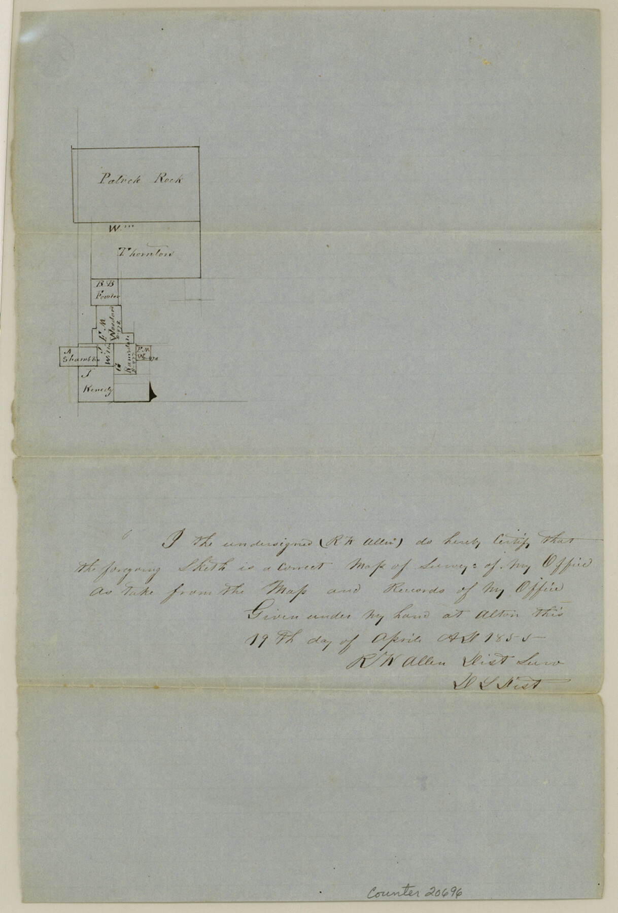
Denton County Sketch File 6
[Sketch on the Denton Fork of Trinity]
-
Map/Doc
20696
-
Collection
General Map Collection
-
Object Dates
1855/4/19 (Creation Date)
1855/8/20 (File Date)
-
People and Organizations
R.W. Allen (Surveyor/Engineer)
-
Counties
Denton
-
Subjects
Surveying Sketch File
-
Height x Width
12.3 x 8.3 inches
31.2 x 21.1 cm
-
Medium
paper, manuscript
-
Features
[Denton Creek]
[Trinity River]
Part of: General Map Collection
Brewster County Sketch File 45

Print $2.00
- Digital $50.00
Brewster County Sketch File 45
Size 10.7 x 8.2 inches
Map/Doc 16312
Falls County Sketch File 11

Print $13.00
- Digital $50.00
Falls County Sketch File 11
1859
Size 12.6 x 9.8 inches
Map/Doc 22352
Throckmorton County Rolled Sketch 5A

Print $20.00
- Digital $50.00
Throckmorton County Rolled Sketch 5A
2001
Size 25.2 x 36.0 inches
Map/Doc 76406
Eastland County Rolled Sketch 3

Print $20.00
- Digital $50.00
Eastland County Rolled Sketch 3
1893
Size 24.4 x 41.3 inches
Map/Doc 5773
Flight Mission No. DQO-2K, Frame 86, Galveston County

Print $20.00
- Digital $50.00
Flight Mission No. DQO-2K, Frame 86, Galveston County
1952
Size 19.0 x 22.5 inches
Map/Doc 85013
Right of Way & Track Map San Antonio & Aransas Pass Railway Co.

Print $40.00
- Digital $50.00
Right of Way & Track Map San Antonio & Aransas Pass Railway Co.
1919
Size 25.2 x 56.7 inches
Map/Doc 64040
Chambers County Sketch File 5

Print $2.00
- Digital $50.00
Chambers County Sketch File 5
Size 7.2 x 6.3 inches
Map/Doc 17539
Baylor County Sketch File A2

Print $4.00
- Digital $50.00
Baylor County Sketch File A2
1899
Size 10.4 x 8.2 inches
Map/Doc 14075
Roberts County Working Sketch 33

Print $20.00
- Digital $50.00
Roberts County Working Sketch 33
1978
Size 26.6 x 22.4 inches
Map/Doc 63559
Nueces County Rolled Sketch 66

Print $46.00
- Digital $50.00
Nueces County Rolled Sketch 66
1979
Size 26.1 x 37.4 inches
Map/Doc 9608
Flight Mission No. DQN-3K, Frame 73, Calhoun County

Print $20.00
- Digital $50.00
Flight Mission No. DQN-3K, Frame 73, Calhoun County
1953
Size 18.6 x 22.4 inches
Map/Doc 84364
Gillespie County Sketch File 3

Print $4.00
- Digital $50.00
Gillespie County Sketch File 3
1847
Size 11.2 x 8.0 inches
Map/Doc 24129
You may also like
Val Verde County Sketch File 40

Print $20.00
- Digital $50.00
Val Verde County Sketch File 40
1939
Size 15.3 x 25.5 inches
Map/Doc 12582
Van Zandt County Sketch File 13

Print $4.00
- Digital $50.00
Van Zandt County Sketch File 13
1858
Size 10.6 x 8.2 inches
Map/Doc 39402
Presidio County Sketch File 111

Print $4.00
- Digital $50.00
Presidio County Sketch File 111
1885
Size 14.3 x 9.1 inches
Map/Doc 34824
Hockley County Working Sketch 2

Print $20.00
- Digital $50.00
Hockley County Working Sketch 2
1960
Size 17.8 x 35.7 inches
Map/Doc 66192
Hidalgo County Working Sketch 7

Print $40.00
- Digital $50.00
Hidalgo County Working Sketch 7
1963
Size 26.4 x 73.9 inches
Map/Doc 66184
Yoakum County Sketch File 19

Print $18.00
- Digital $50.00
Yoakum County Sketch File 19
1898
Size 11.5 x 8.8 inches
Map/Doc 40832
The Judicial District/County of Menard. December 7, 1841

Print $20.00
The Judicial District/County of Menard. December 7, 1841
2020
Size 22.4 x 21.7 inches
Map/Doc 96336
Franklin County Working Sketch Graphic Index

Print $20.00
- Digital $50.00
Franklin County Working Sketch Graphic Index
1942
Size 40.3 x 16.2 inches
Map/Doc 76546
Jeff Davis County Working Sketch 33

Print $40.00
- Digital $50.00
Jeff Davis County Working Sketch 33
1977
Size 28.8 x 48.3 inches
Map/Doc 66528
Bandera County Working Sketch 45

Print $20.00
- Digital $50.00
Bandera County Working Sketch 45
1981
Size 42.4 x 35.5 inches
Map/Doc 67641
Flight Mission No. BRA-16M, Frame 62, Jefferson County

Print $20.00
- Digital $50.00
Flight Mission No. BRA-16M, Frame 62, Jefferson County
1953
Size 18.7 x 22.4 inches
Map/Doc 85679
Lubbock County Working Sketch 6

Print $20.00
- Digital $50.00
Lubbock County Working Sketch 6
1959
Size 25.1 x 22.4 inches
Map/Doc 70666