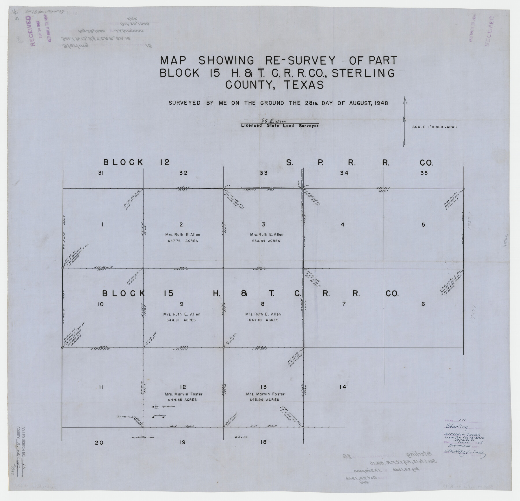
Sterling County Rolled Sketch 15
Map showing re-survey of part Block 15, H. & T. C. R.R. Co., Sterling County, Texas
-
Map/Doc
9947
-
Collection
General Map Collection
-
Object Dates
1948/8/28 (Survey Date)
1948/10/25 (File Date)
-
People and Organizations
J.A. Simpson (Surveyor/Engineer)
-
Counties
Sterling
-
Subjects
Surveying Rolled Sketch
-
Height x Width
30.0 x 31.2 inches
76.2 x 79.2 cm
-
Medium
linen, manuscript
-
Scale
1" = 400 varas
Part of: General Map Collection
Wilbarger County Rolled Sketch 3

Print $40.00
- Digital $50.00
Wilbarger County Rolled Sketch 3
Size 39.5 x 67.4 inches
Map/Doc 10141
Harrison County

Print $20.00
- Digital $50.00
Harrison County
1857
Size 20.3 x 21.0 inches
Map/Doc 1116
Menard County Sketch File 7

Print $4.00
- Digital $50.00
Menard County Sketch File 7
Size 5.8 x 12.0 inches
Map/Doc 31492
[Right of Way & Track Map, The Texas & Pacific Ry. Co. Main Line]
![64682, [Right of Way & Track Map, The Texas & Pacific Ry. Co. Main Line], General Map Collection](https://historictexasmaps.com/wmedia_w700/maps/64682.tif.jpg)
Print $20.00
- Digital $50.00
[Right of Way & Track Map, The Texas & Pacific Ry. Co. Main Line]
Size 11.4 x 18.4 inches
Map/Doc 64682
Montgomery County Rolled Sketch 40A

Print $40.00
- Digital $50.00
Montgomery County Rolled Sketch 40A
1970
Size 40.4 x 57.5 inches
Map/Doc 9547
City of Austin, Texas and Suburban Areas

Print $40.00
- Digital $50.00
City of Austin, Texas and Suburban Areas
1964
Size 48.3 x 34.4 inches
Map/Doc 73563
Hudspeth County Working Sketch 55

Print $20.00
- Digital $50.00
Hudspeth County Working Sketch 55
1989
Size 22.3 x 29.5 inches
Map/Doc 66340
Lampasas County Sketch File 4

Print $4.00
- Digital $50.00
Lampasas County Sketch File 4
1861
Size 12.3 x 8.2 inches
Map/Doc 29394
Limestone County Working Sketch 3

Print $20.00
- Digital $50.00
Limestone County Working Sketch 3
1919
Size 28.9 x 28.5 inches
Map/Doc 70553
Flight Mission No. BRA-7M, Frame 11, Jefferson County

Print $20.00
- Digital $50.00
Flight Mission No. BRA-7M, Frame 11, Jefferson County
1953
Size 18.6 x 22.3 inches
Map/Doc 85462
Photostat of section of hydrographic surveys H-5399, H-4822, H-470

Print $20.00
- Digital $50.00
Photostat of section of hydrographic surveys H-5399, H-4822, H-470
1933
Size 18.4 x 25.8 inches
Map/Doc 61160
Navarro County Boundary File 2

Print $12.00
- Digital $50.00
Navarro County Boundary File 2
Size 8.8 x 3.9 inches
Map/Doc 57608
You may also like
Hunt County Rolled Sketch 5

Print $20.00
- Digital $50.00
Hunt County Rolled Sketch 5
1956
Size 28.6 x 24.3 inches
Map/Doc 6268
Upton County Working Sketch 57

Print $20.00
- Digital $50.00
Upton County Working Sketch 57
1988
Size 28.9 x 37.4 inches
Map/Doc 69554
Brewster County Sketch File N-21

Print $40.00
- Digital $50.00
Brewster County Sketch File N-21
1951
Size 18.0 x 18.6 inches
Map/Doc 10968
Brewster County Working Sketch 77

Print $20.00
- Digital $50.00
Brewster County Working Sketch 77
1968
Size 25.0 x 20.9 inches
Map/Doc 67677
Jones County Sketch File 20

Print $4.00
- Digital $50.00
Jones County Sketch File 20
1875
Size 14.2 x 8.8 inches
Map/Doc 28543
Texas-United States Boundary Line 1

Print $4.00
- Digital $50.00
Texas-United States Boundary Line 1
1843
Size 12.6 x 7.8 inches
Map/Doc 74974
Steele Addition, Seagraves, Texas

Print $20.00
- Digital $50.00
Steele Addition, Seagraves, Texas
Size 17.4 x 26.3 inches
Map/Doc 92655
[Archer County School Land, Sections 1,2,3,4, Blocks GG, I, 29, A2, C3]
![92914, [Archer County School Land, Sections 1,2,3,4, Blocks GG, I, 29, A2, C3], Twichell Survey Records](https://historictexasmaps.com/wmedia_w700/maps/92914-1.tif.jpg)
Print $20.00
- Digital $50.00
[Archer County School Land, Sections 1,2,3,4, Blocks GG, I, 29, A2, C3]
Size 25.9 x 18.7 inches
Map/Doc 92914
Val Verde County Sketch File A

Print $20.00
- Digital $50.00
Val Verde County Sketch File A
1878
Size 25.6 x 16.0 inches
Map/Doc 12538
Zapata County

Print $40.00
- Digital $50.00
Zapata County
1935
Size 56.7 x 43.2 inches
Map/Doc 63145
Hockley County Sketch File 5

Print $4.00
- Digital $50.00
Hockley County Sketch File 5
Size 9.1 x 11.2 inches
Map/Doc 26539
Guadalupe County Sketch File 24

Print $4.00
- Digital $50.00
Guadalupe County Sketch File 24
1838
Size 12.9 x 8.4 inches
Map/Doc 24715