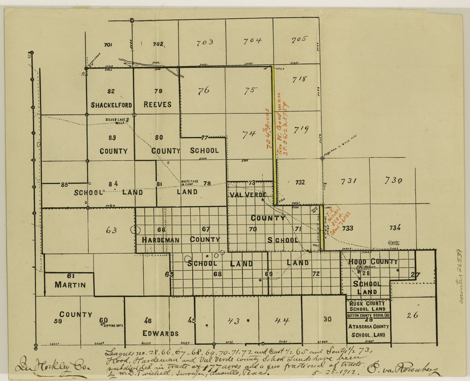
Hockley County Sketch File 5
[Sketch of County School Lands]
-
Map/Doc
26539
-
Collection
General Map Collection
-
People and Organizations
W.D. Twichell (Surveyor/Engineer)
-
Counties
Hockley Cochran
-
Subjects
Surveying Sketch File
-
Height x Width
9.1 x 11.2 inches
23.1 x 28.5 cm
-
Medium
paper, print with manuscript additions
-
Features
Silver Lake Mills
White Face Camp
Hickley City
Part of: General Map Collection
Irion County Boundary File 3a

Print $2.00
- Digital $50.00
Irion County Boundary File 3a
Size 12.9 x 8.3 inches
Map/Doc 55349
Orange County Working Sketch 39

Print $20.00
- Digital $50.00
Orange County Working Sketch 39
1966
Size 20.5 x 27.8 inches
Map/Doc 71371
Montgomery County Working Sketch 43

Print $20.00
- Digital $50.00
Montgomery County Working Sketch 43
1956
Size 29.9 x 25.9 inches
Map/Doc 71150
Cochran County

Print $20.00
- Digital $50.00
Cochran County
1899
Size 41.1 x 34.1 inches
Map/Doc 66755
Calhoun County Rolled Sketch 35

Print $20.00
- Digital $50.00
Calhoun County Rolled Sketch 35
1929
Size 36.5 x 26.6 inches
Map/Doc 5511
Hardeman County Sketch File 8

Print $8.00
- Digital $50.00
Hardeman County Sketch File 8
Size 12.8 x 8.2 inches
Map/Doc 25002
Brewster County Sketch File FN-34

Print $40.00
- Digital $50.00
Brewster County Sketch File FN-34
1943
Size 23.1 x 27.1 inches
Map/Doc 10984
Tom Green Co.

Print $40.00
- Digital $50.00
Tom Green Co.
1887
Size 43.9 x 111.7 inches
Map/Doc 82063
Haskell County Sketch File 19

Print $20.00
- Digital $50.00
Haskell County Sketch File 19
1902
Size 26.9 x 23.1 inches
Map/Doc 11742

Laguna Madre, Register No. 1477A

Print $40.00
- Digital $50.00
Laguna Madre, Register No. 1477A
1880
Size 34.3 x 56.0 inches
Map/Doc 73606
Flight Mission No. DAG-24K, Frame 37, Matagorda County

Print $20.00
- Digital $50.00
Flight Mission No. DAG-24K, Frame 37, Matagorda County
1953
Size 18.5 x 22.2 inches
Map/Doc 86524
You may also like
Flight Mission No. CRC-5R, Frame 16, Chambers County

Print $20.00
- Digital $50.00
Flight Mission No. CRC-5R, Frame 16, Chambers County
1956
Size 18.6 x 22.4 inches
Map/Doc 84938
Map of the 1st, 2nd and 3rd Sections of Houston & Texas Central Railroad

Print $40.00
- Digital $50.00
Map of the 1st, 2nd and 3rd Sections of Houston & Texas Central Railroad
Size 30.7 x 64.6 inches
Map/Doc 64478
United States - Gulf Coast - From Latitude 26° 33' to the Rio Grande Texas

Print $20.00
- Digital $50.00
United States - Gulf Coast - From Latitude 26° 33' to the Rio Grande Texas
1913
Size 27.8 x 18.4 inches
Map/Doc 72831
Ector County Working Sketch 13

Print $40.00
- Digital $50.00
Ector County Working Sketch 13
1955
Size 71.8 x 43.5 inches
Map/Doc 68856


Hill County Working Sketch 1

Print $20.00
- Digital $50.00
Hill County Working Sketch 1
1939
Size 11.0 x 17.8 inches
Map/Doc 66187
Stonewall County Rolled Sketch 28

Print $20.00
- Digital $50.00
Stonewall County Rolled Sketch 28
Size 42.8 x 46.5 inches
Map/Doc 9967
Flight Mission No. DCL-7C, Frame 109, Kenedy County

Print $20.00
- Digital $50.00
Flight Mission No. DCL-7C, Frame 109, Kenedy County
1943
Size 18.6 x 22.2 inches
Map/Doc 86074
Navigation Maps of Gulf Intracoastal Waterway, Port Arthur to Brownsville, Texas

Print $4.00
- Digital $50.00
Navigation Maps of Gulf Intracoastal Waterway, Port Arthur to Brownsville, Texas
1951
Size 16.6 x 21.5 inches
Map/Doc 65440
Houston Ship Channel, Alexander Island to Carpenter Bayou

Print $40.00
- Digital $50.00
Houston Ship Channel, Alexander Island to Carpenter Bayou
1992
Size 36.0 x 49.4 inches
Map/Doc 69918
[F. W. & D. C. Ry. Co. Alignment and Right of Way Map, Clay County]
![64729, [F. W. & D. C. Ry. Co. Alignment and Right of Way Map, Clay County], General Map Collection](https://historictexasmaps.com/wmedia_w700/maps/64729-1.tif.jpg)
Print $20.00
- Digital $50.00
[F. W. & D. C. Ry. Co. Alignment and Right of Way Map, Clay County]
1927
Size 18.5 x 11.7 inches
Map/Doc 64729