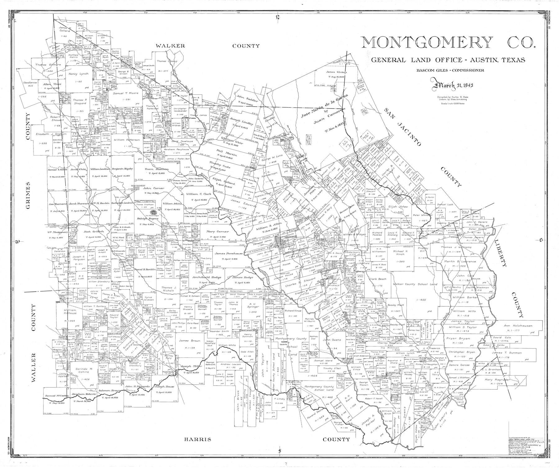
Montgomery Co.
-
Map/Doc
77377
-
Collection
General Map Collection
-
Object Dates
1943/3/31 (Creation Date)
-
People and Organizations
Eltea Armstrong (Draftsman)
Curtis R. Hale (Compiler)
-
Counties
Montgomery
-
Subjects
County
-
Height x Width
44.0 x 52.4 inches
111.8 x 133.1 cm
Part of: General Map Collection
Culberson County Sketch File 13

Print $16.00
- Digital $50.00
Culberson County Sketch File 13
1912
Size 11.2 x 8.7 inches
Map/Doc 20146
Real County Working Sketch 53

Print $20.00
- Digital $50.00
Real County Working Sketch 53
1959
Size 29.4 x 27.9 inches
Map/Doc 71945
Flight Mission No. CRC-3R, Frame 45, Chambers County

Print $20.00
- Digital $50.00
Flight Mission No. CRC-3R, Frame 45, Chambers County
1956
Size 18.6 x 22.5 inches
Map/Doc 84818
Sketch of 103rd Meridian, W. L. Showing Conflict of Capitol Leagues

Print $40.00
- Digital $50.00
Sketch of 103rd Meridian, W. L. Showing Conflict of Capitol Leagues
Size 26.9 x 85.1 inches
Map/Doc 65505
Newton County Working Sketch Graphic Index

Print $20.00
- Digital $50.00
Newton County Working Sketch Graphic Index
1946
Size 47.5 x 41.0 inches
Map/Doc 76653

Flight Mission No. DAG-19K, Frame 57, Matagorda County

Print $20.00
- Digital $50.00
Flight Mission No. DAG-19K, Frame 57, Matagorda County
1952
Size 18.5 x 22.3 inches
Map/Doc 86384

Ward County Working Sketch 5

Print $20.00
- Digital $50.00
Ward County Working Sketch 5
1943
Size 19.1 x 36.5 inches
Map/Doc 72311
Sabine River, North Extension Merrill Lake Sheet

Print $20.00
- Digital $50.00
Sabine River, North Extension Merrill Lake Sheet
1933
Size 23.2 x 42.6 inches
Map/Doc 65140
A General Map of the Middle British Colonies, in America. containing Virginia, Maryland, the Delaware Counties, Pennsylvania and New Jersey. With the addition of New York and of the Greatest Part of New England

Print $20.00
- Digital $50.00
A General Map of the Middle British Colonies, in America. containing Virginia, Maryland, the Delaware Counties, Pennsylvania and New Jersey. With the addition of New York and of the Greatest Part of New England
1776
Size 21.6 x 27.2 inches
Map/Doc 97402
Dallas County Sketch File 20

Print $4.00
- Digital $50.00
Dallas County Sketch File 20
Size 12.2 x 7.8 inches
Map/Doc 20441
You may also like
Coke County Sketch File 27

Print $26.00
- Digital $50.00
Coke County Sketch File 27
1937
Size 11.2 x 8.7 inches
Map/Doc 18638
Blucher's Directory Map of Corpus Christi and Road Map of Nueces County

Print $20.00
- Digital $50.00
Blucher's Directory Map of Corpus Christi and Road Map of Nueces County
1945
Size 22.6 x 34.3 inches
Map/Doc 94106
Flight Mission No. CGI-3N, Frame 68, Cameron County

Print $20.00
- Digital $50.00
Flight Mission No. CGI-3N, Frame 68, Cameron County
1954
Size 18.4 x 22.2 inches
Map/Doc 84562
San Jacinto County Working Sketch 27

Print $20.00
- Digital $50.00
San Jacinto County Working Sketch 27
1944
Size 30.5 x 23.3 inches
Map/Doc 63740
Map of McLennan Co[unty]
![88974, Map of McLennan Co[unty], Library of Congress](https://historictexasmaps.com/wmedia_w700/maps/88974.tif.jpg)
Print $40.00
Map of McLennan Co[unty]
1896
Size 47.9 x 53.6 inches
Map/Doc 88974
General Highway Map, Burleson County, Texas

Print $20.00
General Highway Map, Burleson County, Texas
1961
Size 18.1 x 24.8 inches
Map/Doc 79391
Upton County Working Sketch 55

Print $20.00
- Digital $50.00
Upton County Working Sketch 55
Size 25.7 x 36.7 inches
Map/Doc 69552
Township 4 South Ranges 12 and 13 West, South Western District, Louisiana

Print $20.00
- Digital $50.00
Township 4 South Ranges 12 and 13 West, South Western District, Louisiana
1879
Size 19.6 x 24.7 inches
Map/Doc 65884
General Highway Map, Howard County, Texas

Print $20.00
General Highway Map, Howard County, Texas
1940
Size 18.5 x 24.7 inches
Map/Doc 79134
Old Miscellaneous File 17

Print $24.00
- Digital $50.00
Old Miscellaneous File 17
1908
Size 14.2 x 8.6 inches
Map/Doc 75485
Flight Mission No. DQO-7K, Frame 83, Galveston County

Print $20.00
- Digital $50.00
Flight Mission No. DQO-7K, Frame 83, Galveston County
1952
Size 18.8 x 22.5 inches
Map/Doc 85110
Victoria County Working Sketch Graphic Index

Print $20.00
- Digital $50.00
Victoria County Working Sketch Graphic Index
1921
Size 47.0 x 39.0 inches
Map/Doc 76728