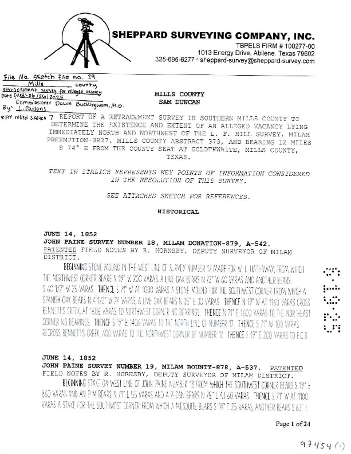
Mills County Sketch File 29
Report to accompany resurvey of the L. F. Hill Survey (Milam Preemption-3827, A-379) and the J. A. Q. Palmer Survey (Milam Preemption-5120, A-763)
-
Map/Doc
97454
-
Collection
General Map Collection
-
Object Dates
5/22/2025 (Creation Date)
6/26/2025 (File Date)
-
People and Organizations
Maxey Sheppard (Surveyor/Engineer)
-
Counties
Mills
-
Subjects
Surveying Sketch File
-
Comments
See Mills Rolled Sketch 7 (97434)
Addresses alleged vacancy, excess acreage, and evidence for corrected patent
Related maps
Mills County Rolled Sketch 7

Print $20.00
- Digital $50.00
Mills County Rolled Sketch 7
2025
Size 23.7 x 29.8 inches
Map/Doc 97434
Part of: General Map Collection
Flight Mission No. CRC-3R, Frame 47, Chambers County

Print $20.00
- Digital $50.00
Flight Mission No. CRC-3R, Frame 47, Chambers County
1956
Size 18.6 x 22.3 inches
Map/Doc 84820
Leon County Working Sketch 22

Print $20.00
- Digital $50.00
Leon County Working Sketch 22
1965
Size 27.9 x 31.1 inches
Map/Doc 70421
Dawson County Boundary File 2

Print $18.00
- Digital $50.00
Dawson County Boundary File 2
Size 14.2 x 8.8 inches
Map/Doc 52338
Rusk County Working Sketch 38

Print $20.00
- Digital $50.00
Rusk County Working Sketch 38
2008
Size 16.3 x 23.3 inches
Map/Doc 88815
Tyler County Sketch File 1

Print $22.00
- Digital $50.00
Tyler County Sketch File 1
1849
Size 12.2 x 15.3 inches
Map/Doc 38607
Cooke County Boundary File 3

Print $4.00
- Digital $50.00
Cooke County Boundary File 3
Size 7.3 x 8.7 inches
Map/Doc 51853
Hudspeth County Rolled Sketch 44

Print $20.00
- Digital $50.00
Hudspeth County Rolled Sketch 44
1951
Size 12.1 x 11.5 inches
Map/Doc 9217
Travis County Sketch File 22

Print $6.00
- Digital $50.00
Travis County Sketch File 22
1875
Size 8.5 x 8.5 inches
Map/Doc 38327
Val Verde County

Print $20.00
- Digital $50.00
Val Verde County
1944
Size 40.8 x 37.7 inches
Map/Doc 78448
Travis County Boundary File 1

Print $8.00
- Digital $50.00
Travis County Boundary File 1
Size 9.0 x 14.6 inches
Map/Doc 59403
Outer Continental Shelf Leasing Maps (Texas Offshore Operations)

Print $20.00
- Digital $50.00
Outer Continental Shelf Leasing Maps (Texas Offshore Operations)
Size 24.0 x 18.4 inches
Map/Doc 75853
[Sketch for Mineral Application 13440]
![2799, [Sketch for Mineral Application 13440], General Map Collection](https://historictexasmaps.com/wmedia_w700/maps/2799-1.tif.jpg)
Print $20.00
- Digital $50.00
[Sketch for Mineral Application 13440]
1925
Size 24.3 x 54.0 inches
Map/Doc 2799
You may also like
Marion County Working Sketch 30

Print $20.00
- Digital $50.00
Marion County Working Sketch 30
1979
Size 31.7 x 38.3 inches
Map/Doc 70806
Brazoria County Sketch File 57

Print $10.00
- Digital $50.00
Brazoria County Sketch File 57
1940
Size 8.7 x 6.3 inches
Map/Doc 15377
Loving County Working Sketch 19

Print $40.00
- Digital $50.00
Loving County Working Sketch 19
1978
Size 54.0 x 29.2 inches
Map/Doc 70653
[Blocks and surveys to the North and West of Jasper County School Land]
![91570, [Blocks and surveys to the North and West of Jasper County School Land], Twichell Survey Records](https://historictexasmaps.com/wmedia_w700/maps/91570-1.tif.jpg)
Print $20.00
- Digital $50.00
[Blocks and surveys to the North and West of Jasper County School Land]
Size 14.9 x 17.8 inches
Map/Doc 91570
Hill County Boundary File 45b

Print $60.00
- Digital $50.00
Hill County Boundary File 45b
Size 7.8 x 3.7 inches
Map/Doc 54772
Hardin County Sketch File 11

Print $8.00
- Digital $50.00
Hardin County Sketch File 11
Size 5.2 x 8.2 inches
Map/Doc 25112
King County Working Sketch 18

Print $20.00
- Digital $50.00
King County Working Sketch 18
1994
Size 31.3 x 35.1 inches
Map/Doc 70182
Castro County Sketch File 4d

Print $4.00
- Digital $50.00
Castro County Sketch File 4d
Size 13.6 x 8.8 inches
Map/Doc 17471
Presidio County Working Sketch 7

Print $20.00
- Digital $50.00
Presidio County Working Sketch 7
1926
Size 35.0 x 40.0 inches
Map/Doc 71681
Flight Mission No. DQO-1K, Frame 116, Galveston County

Print $20.00
- Digital $50.00
Flight Mission No. DQO-1K, Frame 116, Galveston County
1952
Size 18.8 x 22.6 inches
Map/Doc 84994
Lampasas County Working Sketch 14

Print $20.00
- Digital $50.00
Lampasas County Working Sketch 14
1974
Size 23.4 x 21.8 inches
Map/Doc 70291
Denton County Working Sketch 19

Print $20.00
- Digital $50.00
Denton County Working Sketch 19
1976
Size 24.3 x 27.3 inches
Map/Doc 68624