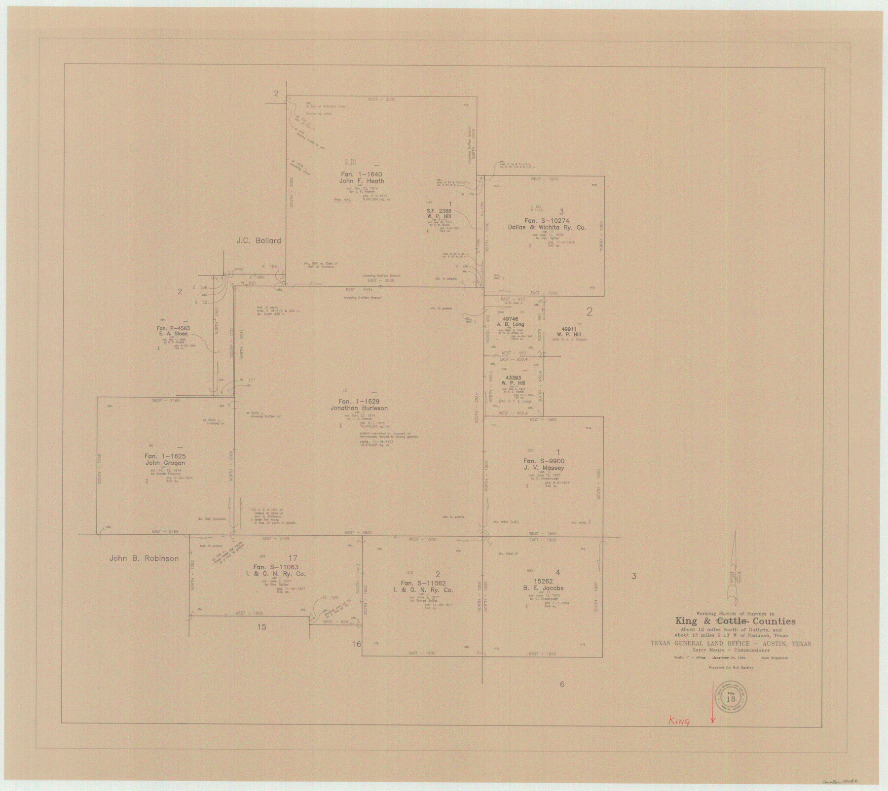
King County Working Sketch 18
-
Map/Doc
70182
-
Collection
General Map Collection
-
Object Dates
6/24/1994 (Creation Date)
-
People and Organizations
Joan Kilpatrick (Draftsman)
-
Counties
King
-
Subjects
Surveying Working Sketch
-
Height x Width
31.3 x 35.1 inches
79.5 x 89.2 cm
-
Scale
1" = 400 varas
Part of: General Map Collection
DeWitt County Working Sketch 4

Print $20.00
- Digital $50.00
DeWitt County Working Sketch 4
1963
Size 37.0 x 45.6 inches
Map/Doc 68594
Erath County Working Sketch 19

Print $20.00
- Digital $50.00
Erath County Working Sketch 19
1963
Size 30.1 x 27.6 inches
Map/Doc 69100
Galveston County NRC Article 33.136 Sketch 18

Print $66.00
- Digital $50.00
Galveston County NRC Article 33.136 Sketch 18
2003
Size 22.4 x 33.9 inches
Map/Doc 78545
Hemphill County Rolled Sketch 13

Print $20.00
- Digital $50.00
Hemphill County Rolled Sketch 13
1905
Size 20.7 x 28.9 inches
Map/Doc 6193
Montague County Sketch File 24

Print $20.00
- Digital $50.00
Montague County Sketch File 24
1941
Size 16.2 x 23.3 inches
Map/Doc 12108
Flight Mission No. DQN-2K, Frame 136, Calhoun County

Print $20.00
- Digital $50.00
Flight Mission No. DQN-2K, Frame 136, Calhoun County
1953
Size 18.5 x 15.8 inches
Map/Doc 84305
Erath County Working Sketch 47

Print $20.00
- Digital $50.00
Erath County Working Sketch 47
1984
Size 16.3 x 18.3 inches
Map/Doc 69128
Location of the Southern Kansas Railway of Texas, Carson County, Texas

Print $40.00
- Digital $50.00
Location of the Southern Kansas Railway of Texas, Carson County, Texas
1887
Size 20.5 x 84.3 inches
Map/Doc 64035
Tyler County Working Sketch 11

Print $20.00
- Digital $50.00
Tyler County Working Sketch 11
1941
Size 23.0 x 17.3 inches
Map/Doc 69481
Kendall County Sketch File 15

Print $4.00
- Digital $50.00
Kendall County Sketch File 15
1860
Size 12.4 x 7.8 inches
Map/Doc 28703
Harris County Rolled Sketch 80A

Print $40.00
- Digital $50.00
Harris County Rolled Sketch 80A
Size 42.8 x 52.6 inches
Map/Doc 9136

You may also like
Upton County Sketch File 35

Print $14.00
- Digital $50.00
Upton County Sketch File 35
1942
Size 11.4 x 8.8 inches
Map/Doc 38886
Map of Texas and the countries adjacent compiled in the Bureau of the Corps of Topographical Engineers from the best authorities for the State Department

Print $20.00
- Digital $50.00
Map of Texas and the countries adjacent compiled in the Bureau of the Corps of Topographical Engineers from the best authorities for the State Department
1844
Size 26.1 x 18.2 inches
Map/Doc 72715
Jackson County Sketch File 22

Print $10.00
- Digital $50.00
Jackson County Sketch File 22
Size 11.2 x 8.7 inches
Map/Doc 27698
Flight Mission No. BRE-1P, Frame 8, Nueces County

Print $20.00
- Digital $50.00
Flight Mission No. BRE-1P, Frame 8, Nueces County
1956
Size 18.3 x 22.1 inches
Map/Doc 86616
Harrison County Working Sketch 28

Print $20.00
- Digital $50.00
Harrison County Working Sketch 28
1992
Size 17.0 x 17.0 inches
Map/Doc 66048
Kerr County Sketch File 19

Print $20.00
- Digital $50.00
Kerr County Sketch File 19
1950
Size 22.8 x 23.9 inches
Map/Doc 11922
Andrews County Sketch File 19

Print $12.00
- Digital $50.00
Andrews County Sketch File 19
Size 14.3 x 8.8 inches
Map/Doc 12912
[Sketch showing surveys in the south half of Potter County, Blocks 6, 20-E, JAD, M-3, S, B. S. & F. Blocks 1 and 9, and A. B. and M. Block 2]
![91741, [Sketch showing surveys in the south half of Potter County, Blocks 6, 20-E, JAD, M-3, S, B. S. & F. Blocks 1 and 9, and A. B. and M. Block 2], Twichell Survey Records](https://historictexasmaps.com/wmedia_w700/maps/91741-1.tif.jpg)
Print $20.00
- Digital $50.00
[Sketch showing surveys in the south half of Potter County, Blocks 6, 20-E, JAD, M-3, S, B. S. & F. Blocks 1 and 9, and A. B. and M. Block 2]
Size 40.5 x 18.1 inches
Map/Doc 91741
Flight Mission No. DAG-26K, Frame 61, Matagorda County

Print $20.00
- Digital $50.00
Flight Mission No. DAG-26K, Frame 61, Matagorda County
1953
Size 18.7 x 22.6 inches
Map/Doc 86581
The Republic County of Washington. May 24, 1838

Print $20.00
The Republic County of Washington. May 24, 1838
2020
Size 20.3 x 21.7 inches
Map/Doc 96303
Flight Mission No. DQO-8K, Frame 142, Galveston County

Print $20.00
- Digital $50.00
Flight Mission No. DQO-8K, Frame 142, Galveston County
1952
Size 18.6 x 22.3 inches
Map/Doc 85204
Correct Map of Lamb County, Texas

Print $40.00
- Digital $50.00
Correct Map of Lamb County, Texas
1914
Size 47.1 x 57.1 inches
Map/Doc 89954