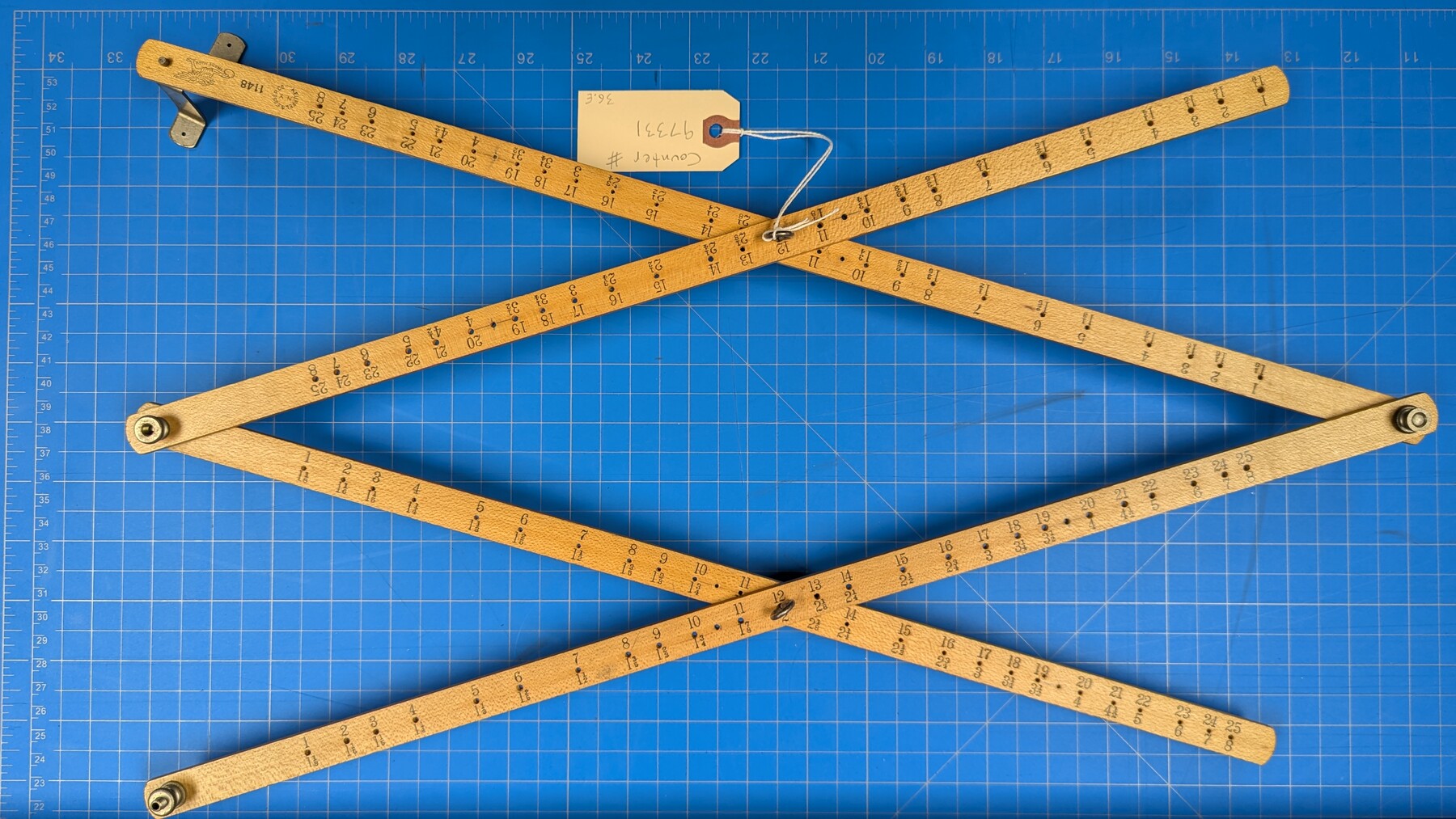
K&E Pantograph, 21" 1148
Manufacturer: Keuffel & Esser Manufacture Location: New York
-
Map/Doc
97331
-
Collection
General Map Collection
-
Height x
21.0 inches
53.3 cm
Part of: General Map Collection
Maps of Gulf Intracoastal Waterway, Texas - Sabine River to the Rio Grande and connecting waterways including ship channels

Print $20.00
- Digital $50.00
Maps of Gulf Intracoastal Waterway, Texas - Sabine River to the Rio Grande and connecting waterways including ship channels
1966
Size 14.5 x 20.8 inches
Map/Doc 61968
Ector County Rolled Sketch HLG

Print $20.00
- Digital $50.00
Ector County Rolled Sketch HLG
1937
Size 45.2 x 30.2 inches
Map/Doc 8835

[Gulf, Colorado & Santa Fe]
![64591, [Gulf, Colorado & Santa Fe], General Map Collection](https://historictexasmaps.com/wmedia_w700/maps/64591.tif.jpg)
Print $40.00
- Digital $50.00
[Gulf, Colorado & Santa Fe]
1918
Size 63.1 x 31.2 inches
Map/Doc 64591
Flight Mission No. BRA-7M, Frame 39, Jefferson County

Print $20.00
- Digital $50.00
Flight Mission No. BRA-7M, Frame 39, Jefferson County
1953
Size 18.7 x 22.5 inches
Map/Doc 85490
Rusk County Sketch File 25

Print $20.00
Rusk County Sketch File 25
1932
Size 20.5 x 20.3 inches
Map/Doc 12272
Hays County Sketch File 31

Print $6.00
- Digital $50.00
Hays County Sketch File 31
1943
Size 14.4 x 8.8 inches
Map/Doc 26261
Clarkson's City Map of Port Aransas

Print $20.00
- Digital $50.00
Clarkson's City Map of Port Aransas
Size 18.5 x 26.5 inches
Map/Doc 3040
San Saba County

Print $20.00
- Digital $50.00
San Saba County
1918
Size 23.6 x 18.4 inches
Map/Doc 78397
Blanco County Sketch File 24

Print $4.00
- Digital $50.00
Blanco County Sketch File 24
Size 8.9 x 14.4 inches
Map/Doc 14614
Calcasieu Pass to Sabine Pass

Print $20.00
- Digital $50.00
Calcasieu Pass to Sabine Pass
1946
Size 45.0 x 35.7 inches
Map/Doc 69807
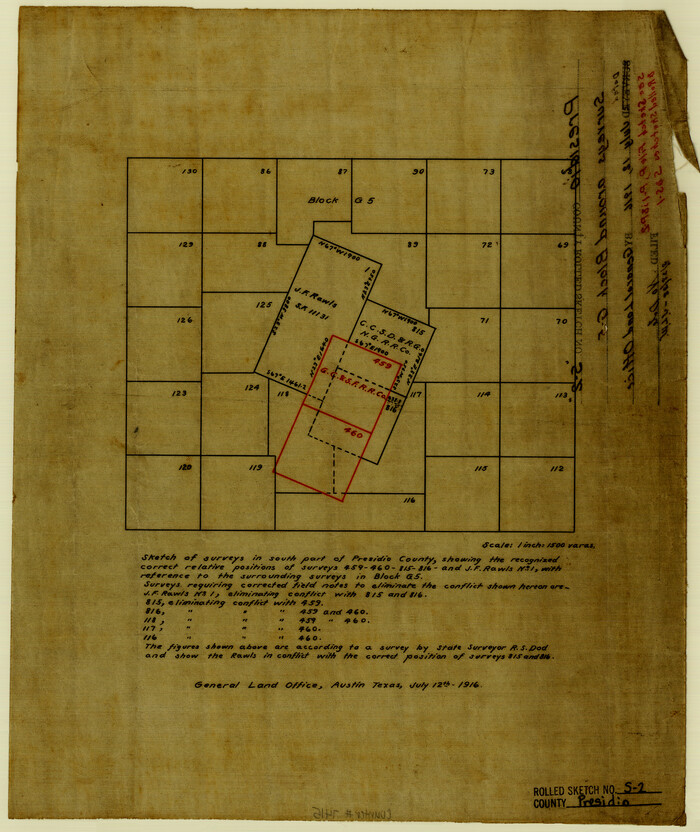
Presidio County Rolled Sketch S2
Print $20.00
- Digital $50.00
Presidio County Rolled Sketch S2
1916
Size 14.2 x 12.0 inches
Map/Doc 7415
You may also like
Coke County Sketch File 16

Print $20.00
- Digital $50.00
Coke County Sketch File 16
1902
Size 18.7 x 16.2 inches
Map/Doc 11108
Right of Way and Track Map Texas & New Orleans R.R. Co. operated by the T. & N. O. R.R. Co. Dallas-Sabine Branch

Print $40.00
- Digital $50.00
Right of Way and Track Map Texas & New Orleans R.R. Co. operated by the T. & N. O. R.R. Co. Dallas-Sabine Branch
1918
Size 26.8 x 56.7 inches
Map/Doc 64151
Controlled Mosaic by Jack Amman Photogrammetric Engineers, Inc - Sheet 1

Print $20.00
- Digital $50.00
Controlled Mosaic by Jack Amman Photogrammetric Engineers, Inc - Sheet 1
1954
Size 20.0 x 24.0 inches
Map/Doc 83445
Flight Mission No. DQO-8K, Frame 86, Galveston County

Print $20.00
- Digital $50.00
Flight Mission No. DQO-8K, Frame 86, Galveston County
1952
Size 18.4 x 22.3 inches
Map/Doc 85188
[Aaron Cherry and A. M. de Lejarza Surveys on the Trinity River]
![91080, [Aaron Cherry and A. M. de Lejarza Surveys on the Trinity River], Twichell Survey Records](https://historictexasmaps.com/wmedia_w700/maps/91080-1.tif.jpg)
Print $20.00
- Digital $50.00
[Aaron Cherry and A. M. de Lejarza Surveys on the Trinity River]
Size 26.3 x 14.1 inches
Map/Doc 91080
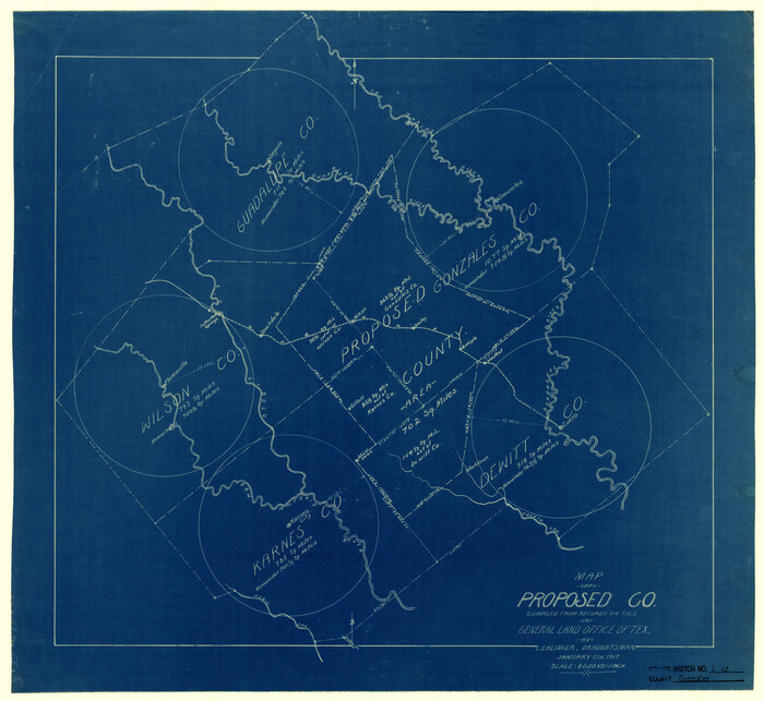
Gonzales County Rolled Sketch 1
Print $20.00
- Digital $50.00
Gonzales County Rolled Sketch 1
1917
Size 22.1 x 24.0 inches
Map/Doc 6028
Jeff Davis County Rolled Sketch 38

Print $20.00
- Digital $50.00
Jeff Davis County Rolled Sketch 38
1994
Size 26.1 x 35.1 inches
Map/Doc 6381
Flight Mission No. DQN-2K, Frame 124, Calhoun County

Print $20.00
- Digital $50.00
Flight Mission No. DQN-2K, Frame 124, Calhoun County
1953
Size 18.5 x 22.2 inches
Map/Doc 84300
Aransas County Working Sketch 9

Print $20.00
- Digital $50.00
Aransas County Working Sketch 9
1947
Size 22.5 x 28.0 inches
Map/Doc 67176
Harris County Sketch File 12

Print $40.00
- Digital $50.00
Harris County Sketch File 12
1896
Size 16.1 x 12.5 inches
Map/Doc 25353
Henderson County Working Sketch 3

Print $20.00
- Digital $50.00
Henderson County Working Sketch 3
Size 28.5 x 38.3 inches
Map/Doc 66136
Atascosa County Sketch File 19

Print $6.00
- Digital $50.00
Atascosa County Sketch File 19
1854
Size 8.8 x 7.2 inches
Map/Doc 13784