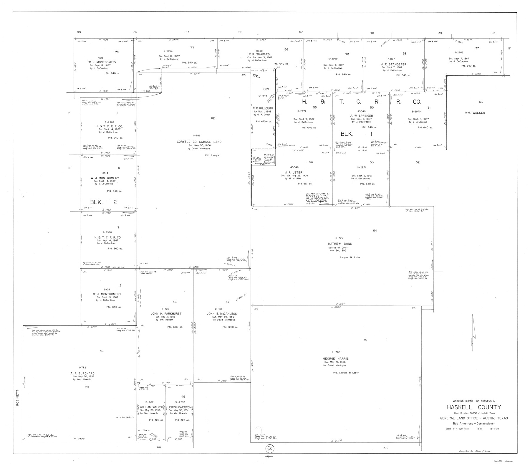
Haskell County Working Sketch 12
-
Map/Doc
66070
-
Collection
General Map Collection
-
Object Dates
12/4/1979 (Creation Date)
-
People and Organizations
Beverly Robison (Draftsman)
-
Counties
Haskell
-
Subjects
Surveying Working Sketch
-
Height x Width
39.3 x 44.2 inches
99.8 x 112.3 cm
-
Scale
1" = 400 varas
Part of: General Map Collection
Texas, Matagorda Bay, Vicinity of Carancahua Bay

Print $40.00
- Digital $50.00
Texas, Matagorda Bay, Vicinity of Carancahua Bay
1933
Size 30.3 x 48.2 inches
Map/Doc 69989
Gaines County Sketch File 12

Print $4.00
- Digital $50.00
Gaines County Sketch File 12
1950
Size 14.3 x 8.8 inches
Map/Doc 23198
Collin County Boundary File 18e

Print $16.00
- Digital $50.00
Collin County Boundary File 18e
Size 6.8 x 8.1 inches
Map/Doc 51749
[Surveys along the Nueces River in San Patricio County]
![69737, [Surveys along the Nueces River in San Patricio County], General Map Collection](https://historictexasmaps.com/wmedia_w700/maps/69737.tif.jpg)
Print $2.00
- Digital $50.00
[Surveys along the Nueces River in San Patricio County]
1842
Size 8.8 x 9.9 inches
Map/Doc 69737
Houston County Sketch File 44

Print $42.00
- Digital $50.00
Houston County Sketch File 44
1847
Size 8.3 x 12.9 inches
Map/Doc 26834
Flight Mission No. BRA-7M, Frame 133, Jefferson County

Print $20.00
- Digital $50.00
Flight Mission No. BRA-7M, Frame 133, Jefferson County
1953
Size 18.6 x 22.3 inches
Map/Doc 85527
Knox County Working Sketch 15

Print $20.00
- Digital $50.00
Knox County Working Sketch 15
1958
Size 29.5 x 32.4 inches
Map/Doc 70257
Cottle County Working Sketch 14B

Print $20.00
- Digital $50.00
Cottle County Working Sketch 14B
1963
Size 35.2 x 41.6 inches
Map/Doc 61795
Hardeman County Sketch File 26

Print $40.00
- Digital $50.00
Hardeman County Sketch File 26
Size 16.3 x 13.2 inches
Map/Doc 25037
Anderson County Working Sketch 29

Print $20.00
- Digital $50.00
Anderson County Working Sketch 29
1962
Size 24.6 x 27.2 inches
Map/Doc 67029
Swisher County Sketch File 5

Print $8.00
- Digital $50.00
Swisher County Sketch File 5
1876
Size 14.3 x 8.8 inches
Map/Doc 37618
Hudspeth County Rolled Sketch 69

Print $20.00
- Digital $50.00
Hudspeth County Rolled Sketch 69
1973
Size 12.2 x 20.8 inches
Map/Doc 7717
You may also like
The Chief Justice Counties. Late Summer 1837

Print $20.00
The Chief Justice Counties. Late Summer 1837
2020
Size 16.8 x 19.1 inches
Map/Doc 96079
Eastland County Boundary File 26

Print $24.00
- Digital $50.00
Eastland County Boundary File 26
Size 7.8 x 3.5 inches
Map/Doc 52801
Montgomery County Working Sketch 31

Print $20.00
- Digital $50.00
Montgomery County Working Sketch 31
Size 24.7 x 18.7 inches
Map/Doc 71138
General Highway Map, Madison County, Texas

Print $20.00
General Highway Map, Madison County, Texas
1961
Size 18.1 x 24.6 inches
Map/Doc 79581
Harrison County

Print $20.00
- Digital $50.00
Harrison County
1857
Size 20.3 x 21.0 inches
Map/Doc 1116
Val Verde County Sketch File 5

Print $10.00
- Digital $50.00
Val Verde County Sketch File 5
1889
Size 11.3 x 8.4 inches
Map/Doc 39180
Duval County Sketch File 84

Print $6.00
- Digital $50.00
Duval County Sketch File 84
1945
Size 14.4 x 8.9 inches
Map/Doc 21531
Harris County Sketch File 67

Print $14.00
- Digital $50.00
Harris County Sketch File 67
1936
Size 11.4 x 8.9 inches
Map/Doc 25505
Webb County Working Sketch 94

Print $20.00
- Digital $50.00
Webb County Working Sketch 94
1989
Size 23.1 x 25.6 inches
Map/Doc 72461
Shelby County Rolled Sketch 15

Print $40.00
- Digital $50.00
Shelby County Rolled Sketch 15
1948
Size 22.8 x 54.4 inches
Map/Doc 10313
[Map of Chicago, Rock Island & Texas Railway through Tarrant County, Texas]
![64413, [Map of Chicago, Rock Island & Texas Railway through Tarrant County, Texas], General Map Collection](https://historictexasmaps.com/wmedia_w700/maps/64413.tif.jpg)
Print $40.00
- Digital $50.00
[Map of Chicago, Rock Island & Texas Railway through Tarrant County, Texas]
1893
Size 22.3 x 121.8 inches
Map/Doc 64413
