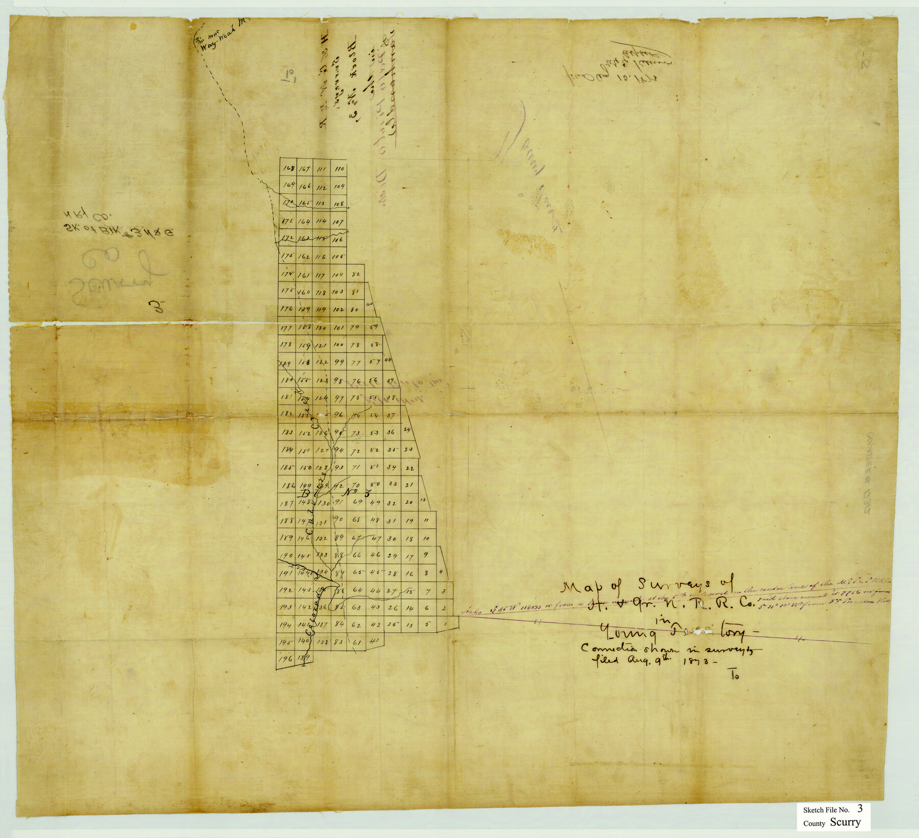
Scurry County Sketch File 3
[Sketch of Block 3, H. & G. N. R.R. Co.]
-
Map/Doc
12312
-
Collection
General Map Collection
-
Object Dates
8/9/1873 (File Date)
-
Counties
Scurry Mitchell
-
Subjects
Surveying Sketch File
-
Height x Width
22.0 x 24.2 inches
55.9 x 61.5 cm
-
Medium
paper, manuscript
-
Features
Wayweah Mountain
Culvurs Creek
Colorado River
Part of: General Map Collection
Dallas County Boundary File 7 and 7a and 7b

Print $26.00
- Digital $50.00
Dallas County Boundary File 7 and 7a and 7b
Size 11.2 x 8.6 inches
Map/Doc 52278
Webb County Sketch File 20

Print $4.00
- Digital $50.00
Webb County Sketch File 20
Size 8.8 x 14.4 inches
Map/Doc 39827
Uvalde County Rolled Sketch 19

Print $20.00
- Digital $50.00
Uvalde County Rolled Sketch 19
Size 21.9 x 20.2 inches
Map/Doc 8103
[Map of the Houston and Great Northern R. R. from Trinity River to Palestine]
![64550, [Map of the Houston and Great Northern R. R. from Trinity River to Palestine], General Map Collection](https://historictexasmaps.com/wmedia_w700/maps/64550.tif.jpg)
Print $40.00
- Digital $50.00
[Map of the Houston and Great Northern R. R. from Trinity River to Palestine]
1872
Size 30.0 x 88.0 inches
Map/Doc 64550
Aransas County Sketch File 13

Print $4.00
- Digital $50.00
Aransas County Sketch File 13
Size 7.0 x 8.4 inches
Map/Doc 13126
Trinity County Sketch File 29

Print $20.00
- Digital $50.00
Trinity County Sketch File 29
1859
Size 18.1 x 37.1 inches
Map/Doc 12488
Flight Mission No. DAG-21K, Frame 130, Matagorda County

Print $20.00
- Digital $50.00
Flight Mission No. DAG-21K, Frame 130, Matagorda County
1952
Size 18.5 x 22.4 inches
Map/Doc 86456
Runnels County Sketch File 36

Print $20.00
Runnels County Sketch File 36
1889
Size 20.9 x 19.6 inches
Map/Doc 12267
Crockett County Rolled Sketch 7

Print $20.00
- Digital $50.00
Crockett County Rolled Sketch 7
Size 18.7 x 14.6 inches
Map/Doc 5580
Sterling County Sketch File 17

Print $8.00
- Digital $50.00
Sterling County Sketch File 17
1936
Size 11.2 x 8.8 inches
Map/Doc 37154
City of Mexia, Texas

Print $40.00
- Digital $50.00
City of Mexia, Texas
1961
Size 71.2 x 43.3 inches
Map/Doc 93671
Map of Mason County

Print $20.00
- Digital $50.00
Map of Mason County
1877
Size 25.3 x 19.9 inches
Map/Doc 3836
You may also like
Edwards County Boundary File 27c

Print $29.00
- Digital $50.00
Edwards County Boundary File 27c
Size 12.8 x 8.1 inches
Map/Doc 52896
Section H Tech Memorial Park, Inc.

Print $20.00
- Digital $50.00
Section H Tech Memorial Park, Inc.
Size 18.0 x 11.3 inches
Map/Doc 92302
Presidio County Working Sketch 101

Print $20.00
- Digital $50.00
Presidio County Working Sketch 101
1979
Size 37.6 x 31.0 inches
Map/Doc 71778
Louisiana and Texas Intracoastal Waterway

Print $20.00
- Digital $50.00
Louisiana and Texas Intracoastal Waterway
1929
Size 13.7 x 19.0 inches
Map/Doc 83344
Railroad Track Map, H&TCRRCo., Falls County, Texas

Print $4.00
- Digital $50.00
Railroad Track Map, H&TCRRCo., Falls County, Texas
1918
Size 11.7 x 18.4 inches
Map/Doc 62862

Flight Mission No. CUG-3P, Frame 193, Kleberg County

Print $20.00
- Digital $50.00
Flight Mission No. CUG-3P, Frame 193, Kleberg County
1956
Size 18.4 x 22.3 inches
Map/Doc 86297
Flight Mission No. DAG-17K, Frame 66, Matagorda County

Print $20.00
- Digital $50.00
Flight Mission No. DAG-17K, Frame 66, Matagorda County
1952
Size 18.5 x 22.3 inches
Map/Doc 86328
Dimmit County Working Sketch 45

Print $20.00
- Digital $50.00
Dimmit County Working Sketch 45
1979
Size 44.7 x 35.5 inches
Map/Doc 68706
San Jacinto County Rolled Sketch 14

Print $20.00
- Digital $50.00
San Jacinto County Rolled Sketch 14
1998
Size 28.0 x 40.0 inches
Map/Doc 7565
Galveston County Sketch File 73f

Print $20.00
- Digital $50.00
Galveston County Sketch File 73f
Size 33.1 x 40.3 inches
Map/Doc 10459
Gaines County Sketch File 23

Print $20.00
- Digital $50.00
Gaines County Sketch File 23
1964
Size 20.0 x 22.8 inches
Map/Doc 11529