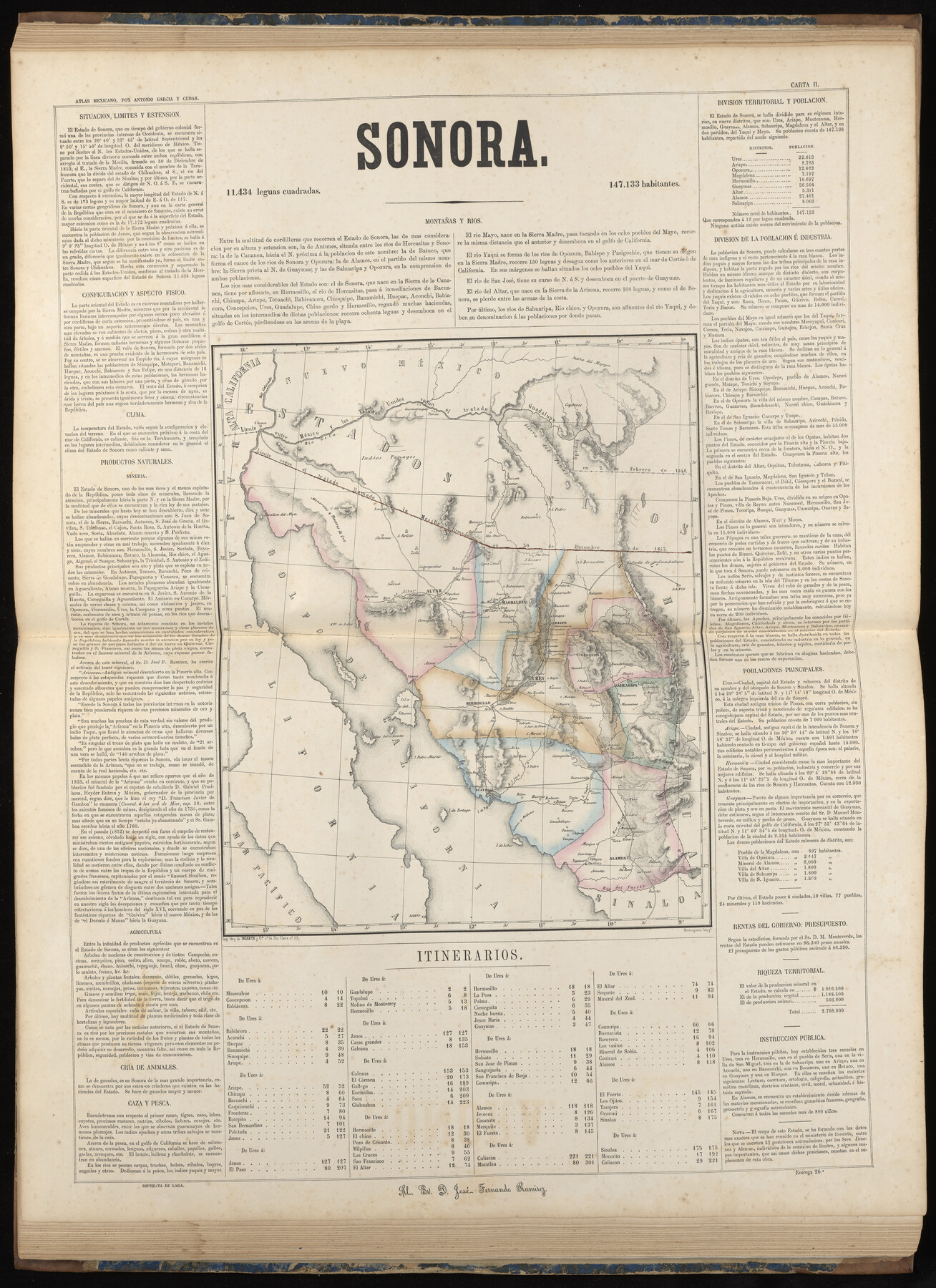
Sonora
-
Map/Doc
97000
-
Collection
General Map Collection
-
Object Dates
1858 (Publication Date)
-
People and Organizations
Antonio García y Cubas (Cartographer)
-
Subjects
Atlas Mexico
-
Height x Width
31.6 x 23.0 inches
80.3 x 58.4 cm
-
Medium
paper, etching/engraving/lithograph
-
Comments
Map 19 of 32 from "Atlas Geografico, Estadistico e Historico de la Republica Mexicana" (95689)
Related maps
Atlas Geográfico, Estadístico é Histórico de la República Mexicana

Atlas Geográfico, Estadístico é Histórico de la República Mexicana
Map/Doc 95689
Part of: General Map Collection
Texas Official Travel Map

Digital $50.00
Texas Official Travel Map
Size 33.3 x 36.2 inches
Map/Doc 94302
Sutton County Sketch File 6a

Print $6.00
- Digital $50.00
Sutton County Sketch File 6a
1898
Size 7.5 x 6.4 inches
Map/Doc 37362
Deaf Smith County Boundary File 1

Print $124.00
- Digital $50.00
Deaf Smith County Boundary File 1
Size 14.1 x 8.6 inches
Map/Doc 52372
[St. Louis & Southwestern]
![64281, [St. Louis & Southwestern], General Map Collection](https://historictexasmaps.com/wmedia_w700/maps/64281.tif.jpg)
Print $20.00
- Digital $50.00
[St. Louis & Southwestern]
Size 20.9 x 29.0 inches
Map/Doc 64281
Sterling County Rolled Sketch 11

Print $20.00
- Digital $50.00
Sterling County Rolled Sketch 11
1884
Size 22.5 x 46.6 inches
Map/Doc 9945
[Surveys along the Colorado River]
![112, [Surveys along the Colorado River], General Map Collection](https://historictexasmaps.com/wmedia_w700/maps/112.tif.jpg)
Print $2.00
- Digital $50.00
[Surveys along the Colorado River]
1841
Size 12.2 x 8.3 inches
Map/Doc 112
Kleberg County Working Sketch 1

Print $20.00
- Digital $50.00
Kleberg County Working Sketch 1
1925
Size 21.9 x 43.8 inches
Map/Doc 70242
Gonzales County Working Sketch 15

Print $20.00
- Digital $50.00
Gonzales County Working Sketch 15
1981
Size 31.1 x 22.4 inches
Map/Doc 63231
Hutchinson County Rolled Sketch 44-6

Print $20.00
- Digital $50.00
Hutchinson County Rolled Sketch 44-6
2002
Size 24.0 x 36.0 inches
Map/Doc 77542
Hale County Sketch File 23

Print $4.00
- Digital $50.00
Hale County Sketch File 23
1903
Size 11.2 x 8.5 inches
Map/Doc 24759

Presidio County Working Sketch 116

Print $20.00
- Digital $50.00
Presidio County Working Sketch 116
1982
Size 27.8 x 42.4 inches
Map/Doc 71793
You may also like
Galveston County Sketch File 48

Print $44.00
- Digital $50.00
Galveston County Sketch File 48
1976
Size 14.3 x 8.8 inches
Map/Doc 23460
Hidalgo County
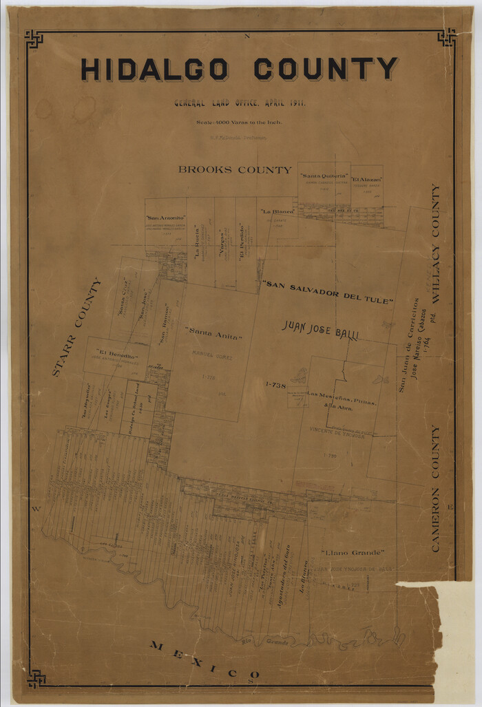
Print $20.00
- Digital $50.00
Hidalgo County
1911
Size 42.1 x 28.7 inches
Map/Doc 16850
Leon County Working Sketch 22

Print $20.00
- Digital $50.00
Leon County Working Sketch 22
1965
Size 27.9 x 31.1 inches
Map/Doc 70421
Foard County Aerial Photograph Index Sheet 3

Print $20.00
- Digital $50.00
Foard County Aerial Photograph Index Sheet 3
1950
Size 20.3 x 18.9 inches
Map/Doc 83690
Johnson County Working Sketch 5

Print $20.00
- Digital $50.00
Johnson County Working Sketch 5
1950
Size 25.8 x 22.3 inches
Map/Doc 66618
Ward County Rolled Sketch 17

Print $20.00
- Digital $50.00
Ward County Rolled Sketch 17
1947
Size 16.2 x 19.5 inches
Map/Doc 8160
Bexar County Sketch File 61

Print $61.00
- Digital $50.00
Bexar County Sketch File 61
2019
Size 11.0 x 8.5 inches
Map/Doc 95709
Right of Way and Track Map, the Missouri, Kansas and Texas Ry. of Texas - Henrietta Division

Print $20.00
- Digital $50.00
Right of Way and Track Map, the Missouri, Kansas and Texas Ry. of Texas - Henrietta Division
1918
Size 11.7 x 26.9 inches
Map/Doc 64749
La Salle County Rolled Sketch 17

Print $20.00
- Digital $50.00
La Salle County Rolled Sketch 17
Size 26.5 x 29.9 inches
Map/Doc 6581
Hamilton County Working Sketch 7

Print $20.00
- Digital $50.00
Hamilton County Working Sketch 7
1942
Size 15.2 x 20.2 inches
Map/Doc 63345
Supreme Court of the United States, October Term, 1923, No. 15, Original - The State of Oklahoma, Complainant vs. The State of Texas, Defendant, The United States, Intervener; Report of Medial Line Survey

Print $28.00
- Digital $50.00
Supreme Court of the United States, October Term, 1923, No. 15, Original - The State of Oklahoma, Complainant vs. The State of Texas, Defendant, The United States, Intervener; Report of Medial Line Survey
1924
Size 5.9 x 9.1 inches
Map/Doc 3055
Map of the Recognised Line M. El. P. & P. R.R. from Texas & Arkansas State Line to Milam & Bexar Land District Line

Print $40.00
- Digital $50.00
Map of the Recognised Line M. El. P. & P. R.R. from Texas & Arkansas State Line to Milam & Bexar Land District Line
1856
Size 14.3 x 89.8 inches
Map/Doc 64053