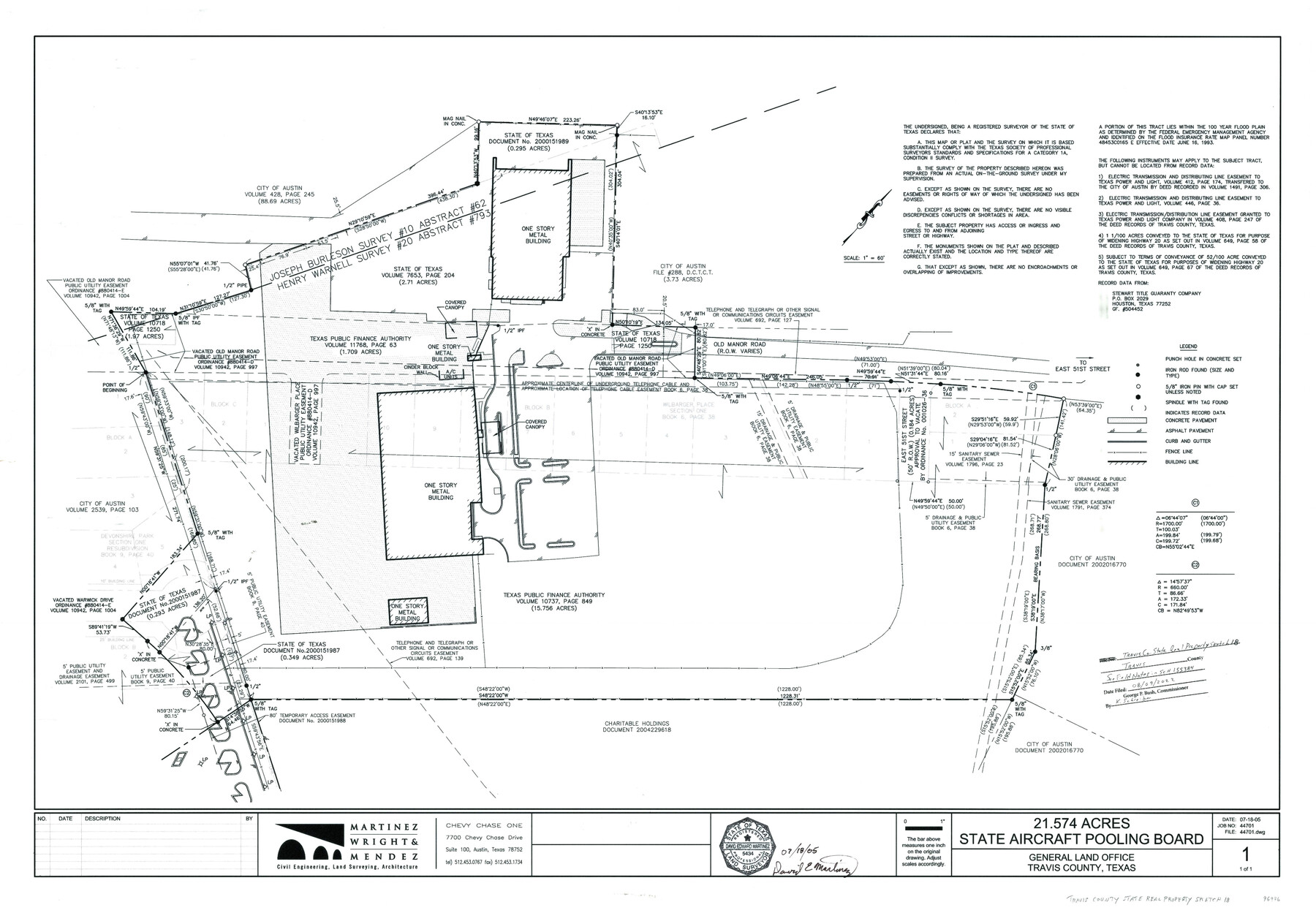
Travis County State Real Property Sketch 18
21.574 acres, State Aircraft Pooling Board
-
Map/Doc
96976
-
Collection
General Map Collection
-
Object Dates
7/18/2005 (Creation Date)
8/9/2022 (File Date)
-
People and Organizations
David E. Martinez (Surveyor/Engineer)
-
Counties
Travis
-
Subjects
State Real Property
-
Height x Width
24.4 x 35.2 inches
62.0 x 89.4 cm
-
Medium
mylar, print
-
Scale
1" = 60 feet
Part of: General Map Collection
Hamilton County

Print $20.00
- Digital $50.00
Hamilton County
1916
Size 41.4 x 40.5 inches
Map/Doc 66851
Dallas County Working Sketch 13

Print $20.00
- Digital $50.00
Dallas County Working Sketch 13
1984
Size 27.9 x 32.6 inches
Map/Doc 68579
Texas Gulf Coast Map from the Sabine River to the Rio Grande as subdivided for mineral development

Print $20.00
- Digital $50.00
Texas Gulf Coast Map from the Sabine River to the Rio Grande as subdivided for mineral development
1948
Size 41.6 x 39.2 inches
Map/Doc 2904
Edwards County Working Sketch 41

Print $20.00
- Digital $50.00
Edwards County Working Sketch 41
1949
Size 29.5 x 30.7 inches
Map/Doc 68917
Brewster County Rolled Sketch 148A

Print $20.00
- Digital $50.00
Brewster County Rolled Sketch 148A
1994
Size 28.0 x 36.3 inches
Map/Doc 5314
Presidio County Sketch File 90

Print $6.00
- Digital $50.00
Presidio County Sketch File 90
Size 16.1 x 11.0 inches
Map/Doc 34761
Bexar County Working Sketch 9

Print $20.00
- Digital $50.00
Bexar County Working Sketch 9
1956
Size 23.4 x 21.6 inches
Map/Doc 67325
Galveston County NRC Article 33.136 Sketch 82

Print $82.00
- Digital $50.00
Galveston County NRC Article 33.136 Sketch 82
2015
Size 24.0 x 36.0 inches
Map/Doc 94601
Bell County Sketch File 6

Print $4.00
- Digital $50.00
Bell County Sketch File 6
Size 6.3 x 7.7 inches
Map/Doc 14373
Geological Map of the Great East Texas Oil Fields

Print $20.00
- Digital $50.00
Geological Map of the Great East Texas Oil Fields
1921
Size 22.6 x 11.7 inches
Map/Doc 94271
Pecos County Working Sketch 128

Print $20.00
- Digital $50.00
Pecos County Working Sketch 128
1975
Size 20.4 x 21.5 inches
Map/Doc 71602
Ector County Sketch File 10

Print $8.00
- Digital $50.00
Ector County Sketch File 10
1930
Size 11.6 x 9.0 inches
Map/Doc 21639
You may also like
Menard County Sketch File 13

Print $4.00
- Digital $50.00
Menard County Sketch File 13
1892
Size 12.8 x 8.2 inches
Map/Doc 31506
Brewster County Working Sketch 88

Print $20.00
- Digital $50.00
Brewster County Working Sketch 88
1973
Size 45.2 x 39.6 inches
Map/Doc 67688
Andrews County Working Sketch 23

Print $20.00
- Digital $50.00
Andrews County Working Sketch 23
1979
Size 26.6 x 27.7 inches
Map/Doc 67069
[Sketch for Mineral Application 16696-16697, Pecos River]
![65614, [Sketch for Mineral Application 16696-16697, Pecos River], General Map Collection](https://historictexasmaps.com/wmedia_w700/maps/65614.tif.jpg)
Print $40.00
- Digital $50.00
[Sketch for Mineral Application 16696-16697, Pecos River]
Size 42.6 x 69.4 inches
Map/Doc 65614
Flight Mission No. DQN-3K, Frame 5, Calhoun County

Print $20.00
- Digital $50.00
Flight Mission No. DQN-3K, Frame 5, Calhoun County
1953
Size 18.4 x 22.1 inches
Map/Doc 84337
DeWitt County Working Sketch 1

Print $20.00
- Digital $50.00
DeWitt County Working Sketch 1
1937
Size 24.2 x 30.8 inches
Map/Doc 68591
Interfaith's Official Map: The Woodlands, a real hometown for people and companies

Interfaith's Official Map: The Woodlands, a real hometown for people and companies
1997
Size 36.7 x 22.5 inches
Map/Doc 94285
Cottle County Sketch File 6a

Print $8.00
- Digital $50.00
Cottle County Sketch File 6a
Size 8.6 x 7.3 inches
Map/Doc 19476
Scurry County Working Sketch 3

Print $20.00
- Digital $50.00
Scurry County Working Sketch 3
1941
Size 20.7 x 12.4 inches
Map/Doc 63832

[Sections 1 & 2, Block S]
![92859, [Sections 1 & 2, Block S], Twichell Survey Records](https://historictexasmaps.com/wmedia_w700/maps/92859-1.tif.jpg)
Print $20.00
- Digital $50.00
[Sections 1 & 2, Block S]
Size 27.8 x 15.7 inches
Map/Doc 92859
[Map of the City of Austin]
![4802, [Map of the City of Austin], General Map Collection](https://historictexasmaps.com/wmedia_w700/maps/4802-1.tif.jpg)
Print $20.00
- Digital $50.00
[Map of the City of Austin]
1856
Size 29.1 x 21.5 inches
Map/Doc 4802