Nueces County NRC Article 33.136 Sketch 20
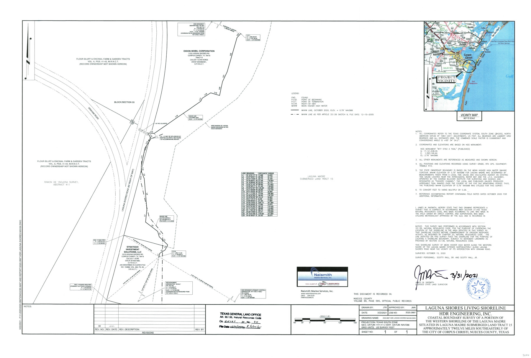
Coastal boundary survey of a portion of the western shoreline of the Laguna Madre situated in Laguna Madre Submerged Land Tract 15 approximately twelve miles southwesterly of the City of Corpus Christi, Nueces County, Texas
-
Map/Doc
96887
-
Collection
General Map Collection
-
Object Dates
2021/3/31 (Creation Date)
2022/6/14 (File Date)
2020/10/15 (Survey Date)
-
People and Organizations
James M. Naismith (Surveyor/Engineer)
Scotty Rall, Sr. (Chainman/Field Personnel)
Scotty Rall, Jr. (Chainman/Field Personnel)
-
Counties
Nueces
-
Subjects
Surveying CBS
-
Medium
multi-page, multi-format
-
Comments
Project: Laguna Madre situated within the Ramon de Ynojosa survey, abstract 411 and Laguna Madre Submerged Land Tract 15 Project No.: CEPRA Project # 1658
Part of: General Map Collection
Flight Mission No. DQN-6K, Frame 6, Calhoun County

Print $20.00
- Digital $50.00
Flight Mission No. DQN-6K, Frame 6, Calhoun County
1953
Size 18.5 x 22.2 inches
Map/Doc 84428
Kleberg County Boundary File 2

Print $22.00
- Digital $50.00
Kleberg County Boundary File 2
Size 14.3 x 8.7 inches
Map/Doc 64966
Flight Mission No. CGI-1N, Frame 137, Cameron County

Print $20.00
- Digital $50.00
Flight Mission No. CGI-1N, Frame 137, Cameron County
1955
Size 15.5 x 18.8 inches
Map/Doc 84493
Galveston County Sketch File 8a

Print $6.00
- Digital $50.00
Galveston County Sketch File 8a
1861
Size 12.1 x 11.8 inches
Map/Doc 23367
El Paso County Sketch File 35 (1)

Print $8.00
- Digital $50.00
El Paso County Sketch File 35 (1)
Size 13.0 x 8.3 inches
Map/Doc 22166
Map of San Jacinto County

Print $20.00
- Digital $50.00
Map of San Jacinto County
1872
Size 22.0 x 18.6 inches
Map/Doc 1346

Plan of the City of Galveston, Texas

Print $20.00
- Digital $50.00
Plan of the City of Galveston, Texas
1845
Size 18.2 x 27.7 inches
Map/Doc 62967
Nueces County Sketch File 27

Print $56.00
- Digital $50.00
Nueces County Sketch File 27
1907
Size 11.1 x 8.7 inches
Map/Doc 32588
Jackson County Rolled Sketch 11

Print $20.00
- Digital $50.00
Jackson County Rolled Sketch 11
1941
Size 45.9 x 34.3 inches
Map/Doc 9260
Eastland County Sketch File 21

Print $8.00
- Digital $50.00
Eastland County Sketch File 21
1990
Size 11.3 x 8.8 inches
Map/Doc 21622
Kaufman County Working Sketch 7

Print $20.00
- Digital $50.00
Kaufman County Working Sketch 7
1984
Size 33.6 x 35.5 inches
Map/Doc 66670
You may also like
Map of the State University & Public School Lands in Reeves and El Paso Cos.

Print $40.00
- Digital $50.00
Map of the State University & Public School Lands in Reeves and El Paso Cos.
1884
Size 39.1 x 56.3 inches
Map/Doc 2434
Map of Galveston, Harrisburg & San Antonio Railway in Pecos County

Print $40.00
- Digital $50.00
Map of Galveston, Harrisburg & San Antonio Railway in Pecos County
1888
Size 26.0 x 80.9 inches
Map/Doc 64399
Karnes County Boundary File 1

Print $14.00
- Digital $50.00
Karnes County Boundary File 1
Size 8.5 x 7.0 inches
Map/Doc 55679
A new map of the states of Texas & California, the territories of Oregon, New Mexico, Utah, and the regions adjacent: compiled from the most recent authorities

Print $20.00
- Digital $50.00
A new map of the states of Texas & California, the territories of Oregon, New Mexico, Utah, and the regions adjacent: compiled from the most recent authorities
1851
Size 22.4 x 20.4 inches
Map/Doc 94051
Borden County Working Sketch 16

Print $40.00
- Digital $50.00
Borden County Working Sketch 16
2007
Size 48.0 x 29.4 inches
Map/Doc 87206
Marion County Sketch File 14

Print $20.00
- Digital $50.00
Marion County Sketch File 14
Size 26.6 x 17.1 inches
Map/Doc 12024
[Plat of Trinity River w/ Midstream Profile in Liberty County by US Government 1899]
![65335, [Plat of Trinity River w/ Midstream Profile in Liberty County by US Government 1899], General Map Collection](https://historictexasmaps.com/wmedia_w700/maps/65335.tif.jpg)
Print $20.00
- Digital $50.00
[Plat of Trinity River w/ Midstream Profile in Liberty County by US Government 1899]
1899
Size 11.5 x 18.3 inches
Map/Doc 65335
Stonewall County

Print $20.00
- Digital $50.00
Stonewall County
1933
Size 40.3 x 34.5 inches
Map/Doc 77428
General Highway Map, Hudspeth County, Texas

Print $20.00
General Highway Map, Hudspeth County, Texas
1961
Size 25.1 x 18.2 inches
Map/Doc 79527
Pecos County, 1917

Print $20.00
- Digital $50.00
Pecos County, 1917
1917
Size 40.5 x 47.4 inches
Map/Doc 89707
El Paso County Boundary File 16

Print $6.00
- Digital $50.00
El Paso County Boundary File 16
Size 14.0 x 8.5 inches
Map/Doc 53189
Hemphill County Rolled Sketch 16

Print $40.00
- Digital $50.00
Hemphill County Rolled Sketch 16
1961
Size 65.4 x 26.9 inches
Map/Doc 9156