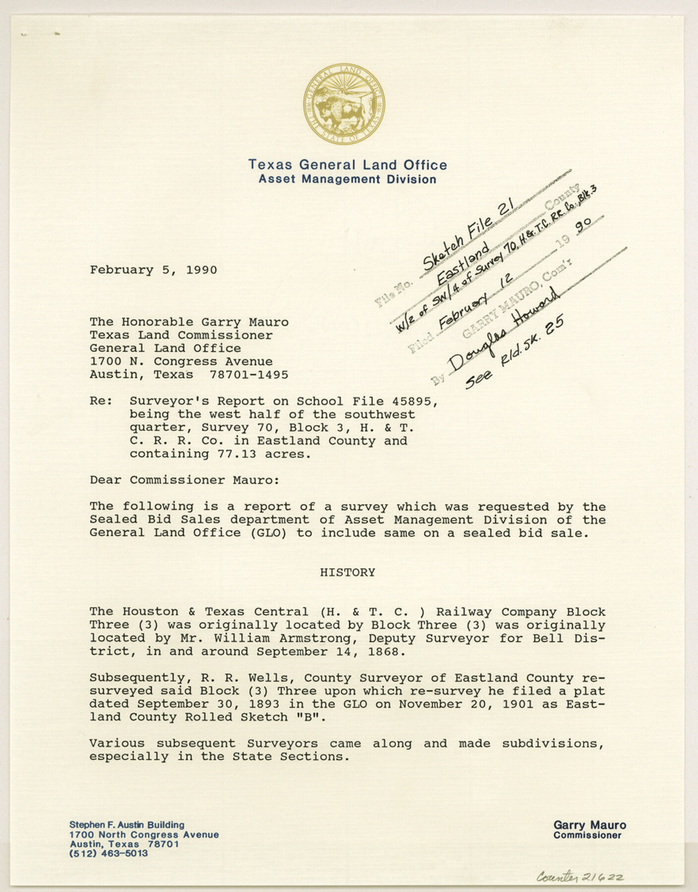
Eastland County Sketch File 21
[Surveyor's report on School File 45895, being the west half of the southwest quarter of survey 70, Block 3, H. & T. C. RR. Co. containing 77.13 acres]
-
Map/Doc
21622
-
Collection
General Map Collection
-
Object Dates
1990/2/5 (Creation Date)
1990/2/12 (File Date)
1868/9/4 (Survey Date)
1893/9/30 (Survey Date)
-
People and Organizations
Elisandro Leos (Surveyor/Engineer)
William Armstrong (Surveyor/Engineer)
R.R. Wells (Surveyor/Engineer)
T.H. Landon (Surveyor/Engineer)
-
Counties
Eastland
-
Subjects
Surveying Sketch File
-
Height x Width
11.3 x 8.8 inches
28.7 x 22.4 cm
-
Medium
paper, print
-
Comments
See Eastland County Rolled Sketch 25 (8831) for sketch.
Related maps
Eastland County Rolled Sketch 25

Print $20.00
- Digital $50.00
Eastland County Rolled Sketch 25
1990
Size 36.9 x 47.7 inches
Map/Doc 8831
Part of: General Map Collection
Presidio County Rolled Sketch 135

Print $20.00
- Digital $50.00
Presidio County Rolled Sketch 135
1996
Size 38.4 x 26.8 inches
Map/Doc 7402
Concho County Rolled Sketch 9

Print $20.00
- Digital $50.00
Concho County Rolled Sketch 9
1956
Size 18.9 x 14.0 inches
Map/Doc 5547
Montgomery County Working Sketch 16

Print $20.00
- Digital $50.00
Montgomery County Working Sketch 16
1934
Size 28.9 x 33.7 inches
Map/Doc 71123
Wilbarger County Working Sketch 7a and 7b

Print $20.00
- Digital $50.00
Wilbarger County Working Sketch 7a and 7b
1951
Size 22.7 x 24.0 inches
Map/Doc 72545
Brown County Sketch File 19

Print $8.00
- Digital $50.00
Brown County Sketch File 19
1873
Size 12.8 x 8.2 inches
Map/Doc 16616
Duval County Sketch File 6b

Print $5.00
- Digital $50.00
Duval County Sketch File 6b
1875
Size 8.3 x 10.8 inches
Map/Doc 21290
Right of Way and Track Map Texas & New Orleans R.R. Co. operated by the T. & N. O. R.R. Co. Dallas-Sabine Branch

Print $40.00
- Digital $50.00
Right of Way and Track Map Texas & New Orleans R.R. Co. operated by the T. & N. O. R.R. Co. Dallas-Sabine Branch
1918
Size 26.1 x 56.7 inches
Map/Doc 64150
Matagorda County Sketch File 13

Print $20.00
- Digital $50.00
Matagorda County Sketch File 13
1902
Size 21.5 x 19.0 inches
Map/Doc 12039
Wise County Working Sketch 13

Print $20.00
- Digital $50.00
Wise County Working Sketch 13
1971
Size 27.9 x 34.0 inches
Map/Doc 72627
Kinney County Working Sketch 33

Print $20.00
- Digital $50.00
Kinney County Working Sketch 33
1962
Size 39.0 x 44.2 inches
Map/Doc 70215
Zavala County Sketch File A1

Print $31.00
- Digital $50.00
Zavala County Sketch File A1
1899
Size 23.5 x 28.6 inches
Map/Doc 12735
Rusk County Working Sketch 37a

Print $40.00
- Digital $50.00
Rusk County Working Sketch 37a
2007
Size 54.5 x 34.2 inches
Map/Doc 87496
You may also like
El Paso County Boundary File 5

Print $80.00
- Digital $50.00
El Paso County Boundary File 5
Size 34.7 x 48.4 inches
Map/Doc 53078
[Sketch filed with corrected field notes of Surveys 27, 28, 29 and 30, Block B-19, PSL]
![91848, [Sketch filed with corrected field notes of Surveys 27, 28, 29 and 30, Block B-19, PSL], Twichell Survey Records](https://historictexasmaps.com/wmedia_w700/maps/91848-1.tif.jpg)
Print $20.00
- Digital $50.00
[Sketch filed with corrected field notes of Surveys 27, 28, 29 and 30, Block B-19, PSL]
1943
Size 19.9 x 15.1 inches
Map/Doc 91848
Flight Mission No. BQY-15M, Frame 18, Harris County

Print $20.00
- Digital $50.00
Flight Mission No. BQY-15M, Frame 18, Harris County
1953
Size 18.6 x 22.5 inches
Map/Doc 85316
Chambers County Boundary File 1

Print $28.00
- Digital $50.00
Chambers County Boundary File 1
Size 8.9 x 6.7 inches
Map/Doc 51226
Jeff Davis County Rolled Sketch 28

Print $20.00
- Digital $50.00
Jeff Davis County Rolled Sketch 28
1977
Size 41.0 x 30.5 inches
Map/Doc 6376
Clay County Boundary File 19

Print $8.00
- Digital $50.00
Clay County Boundary File 19
1924
Size 3.3 x 5.5 inches
Map/Doc 65511
Flight Mission No. DQN-5K, Frame 141, Calhoun County

Print $20.00
- Digital $50.00
Flight Mission No. DQN-5K, Frame 141, Calhoun County
1953
Size 18.7 x 21.9 inches
Map/Doc 84416

Flight Mission No. DQO-1K, Frame 40, Galveston County

Print $20.00
- Digital $50.00
Flight Mission No. DQO-1K, Frame 40, Galveston County
1952
Size 18.8 x 22.6 inches
Map/Doc 84983
Nueces County Rolled Sketch 46

Print $45.00
- Digital $50.00
Nueces County Rolled Sketch 46
Size 10.2 x 15.1 inches
Map/Doc 47859
Scurry County Sketch File 1

Print $6.00
- Digital $50.00
Scurry County Sketch File 1
Size 14.5 x 9.1 inches
Map/Doc 36560
Harrison County Working Sketch 20

Print $20.00
- Digital $50.00
Harrison County Working Sketch 20
1979
Size 15.3 x 19.5 inches
Map/Doc 66040