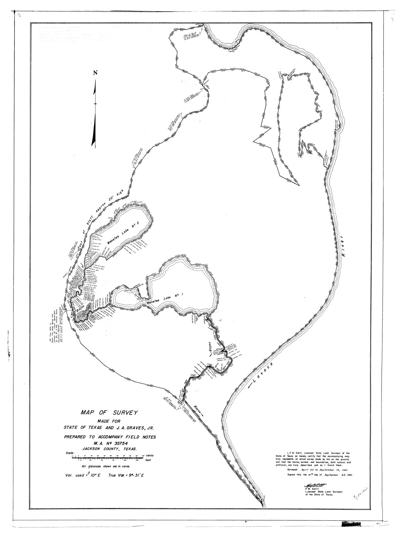
Jackson County Rolled Sketch 11
Map of survey made for State of Texas and J.A. Graves, Jr. prepared to accompany field notes, M.A. No. 35754, Jackson County, Texas
- 
                          Map/Doc
9260
 - 
                            Collection
General Map Collection
 - 
                            Object Dates
1941/9/15 (Creation Date)
1941/9/15 (File Date)
 - 
                            People and Organizations
F.W. Estill (Surveyor/Engineer)
 - 
                            Counties
Jackson
 - 
                            Subjects
Surveying Rolled Sketch
 - 
                            Height x Width
45.9 x 34.3 inches
116.6 x 87.1 cm
 
Related maps
            Jackson County Sketch File 30


                                            Print $52.00                    
                                             -                         Digital $50.00                                    
                Jackson County Sketch File 30
1944
Size 14.2 x 8.5 inches
                                Map/Doc 27730
            Part of: General Map Collection
            La Salle County Rolled Sketch 14B


                                            Print $20.00                    
                                             -                         Digital $50.00                                    
                La Salle County Rolled Sketch 14B
Size 20.7 x 23.0 inches
                                Map/Doc 6578
            
            Upton County Working Sketch Graphic Index, Sheet 1 (Sketches 1 to 39)


                                            Print $40.00                    
                                             -                         Digital $50.00                                    
                Upton County Working Sketch Graphic Index, Sheet 1 (Sketches 1 to 39)
1969
Size 49.9 x 37.0 inches
                                Map/Doc 76721
            
            Newton County Working Sketch 5


                                            Print $20.00                    
                                             -                         Digital $50.00                                    
                Newton County Working Sketch 5
1926
Size 16.0 x 20.0 inches
                                Map/Doc 71251
            
            Map of the Gainesville, Henrietta & Western Railway


                                            Print $20.00                    
                                             -                         Digital $50.00                                    
                Map of the Gainesville, Henrietta & Western Railway
1887
Size 9.6 x 41.7 inches
                                Map/Doc 64482
            
            Henderson County Working Sketch 21


                                            Print $20.00                    
                                             -                         Digital $50.00                                    
                Henderson County Working Sketch 21
1948
Size 17.1 x 16.2 inches
                                Map/Doc 66154
            
            Calhoun County NRC Article 33.136 Sketch 8


                                            Print $28.00                    
                                             -                         Digital $50.00                                    
                Calhoun County NRC Article 33.136 Sketch 8
2019
Size 17.9 x 23.8 inches
                                Map/Doc 95371
            
            Flight Mission No. BQR-5K, Frame 63, Brazoria County


                                            Print $20.00                    
                                             -                         Digital $50.00                                    
                Flight Mission No. BQR-5K, Frame 63, Brazoria County
1952
Size 19.0 x 22.6 inches
                                Map/Doc 84008
            
            McMullen County Sketch File 19


                                            Print $4.00                    
                                             -                         Digital $50.00                                    
                McMullen County Sketch File 19
Size 12.8 x 8.1 inches
                                Map/Doc 31371
            
            Maps of Gulf Intracoastal Waterway, Texas - Sabine River to the Rio Grande and connecting waterways including ship channels


                                            Print $20.00                    
                                             -                         Digital $50.00                                    
                Maps of Gulf Intracoastal Waterway, Texas - Sabine River to the Rio Grande and connecting waterways including ship channels
1966
Size 14.6 x 21.7 inches
                                Map/Doc 61981
            
            [St. L. S-W. Ry. of Texas Map of Lufkin Branch in Angelina County, Texas]


                                            Print $40.00                    
                                             -                         Digital $50.00                                    
                [St. L. S-W. Ry. of Texas Map of Lufkin Branch in Angelina County, Texas]
1913
Size 25.7 x 121.3 inches
                                Map/Doc 64560
            
            Hutchinson County Working Sketch 6


                                            Print $20.00                    
                                             -                         Digital $50.00                                    
                Hutchinson County Working Sketch 6
1914
Size 20.2 x 29.0 inches
                                Map/Doc 66364
            You may also like
            Live Oak County Rolled Sketch 9


                                            Print $20.00                    
                                             -                         Digital $50.00                                    
                Live Oak County Rolled Sketch 9
1982
Size 25.6 x 23.3 inches
                                Map/Doc 6636
            
            Jefferson County Rolled Sketch 21


                                            Print $20.00                    
                                             -                         Digital $50.00                                    
                Jefferson County Rolled Sketch 21
Size 12.0 x 12.1 inches
                                Map/Doc 6387
            
            Blanco County Sketch File 51


                                            Print $8.00                    
                                             -                         Digital $50.00                                    
                Blanco County Sketch File 51
1998
Size 11.1 x 8.5 inches
                                Map/Doc 14697
            
            Maps of Gulf Intracoastal Waterway, Texas - Sabine River to the Rio Grande and connecting waterways including ship channels


                                            Print $20.00                    
                                             -                         Digital $50.00                                    
                Maps of Gulf Intracoastal Waterway, Texas - Sabine River to the Rio Grande and connecting waterways including ship channels
1966
Size 14.5 x 22.2 inches
                                Map/Doc 61964
            
            Pecos County Working Sketch 142


                                            Print $40.00                    
                                             -                         Digital $50.00                                    
                Pecos County Working Sketch 142
2007
Size 38.0 x 63.4 inches
                                Map/Doc 88610
            
            Franklin County Working Sketch 1


                                            Print $20.00                    
                                             -                         Digital $50.00                                    
                Franklin County Working Sketch 1
1915
Size 20.4 x 11.8 inches
                                Map/Doc 69239
            
            Map of Maryland, Virginia, North Carolina and South Carolina


                                            Print $20.00                    
                                             -                         Digital $50.00                                    
                Map of Maryland, Virginia, North Carolina and South Carolina
1885
Size 12.2 x 9.0 inches
                                Map/Doc 93517
            
            Mills County Sketch File 27


                                            Print $8.00                    
                                             -                         Digital $50.00                                    
                Mills County Sketch File 27
2000
Size 14.4 x 8.7 inches
                                Map/Doc 31680
            
            [Maps of surveys in Reeves & Culberson Cos]


                                            Print $20.00                    
                                             -                         Digital $50.00                                    
                [Maps of surveys in Reeves & Culberson Cos]
1937
Size 30.7 x 25.0 inches
                                Map/Doc 61129
            
            [Sketch showing Blocks B5 and B6 and Capitol Land Reservation]


                                            Print $20.00                    
                                             -                         Digital $50.00                                    
                [Sketch showing Blocks B5 and B6 and Capitol Land Reservation]
Size 46.3 x 41.9 inches
                                Map/Doc 89973
            
            Armstrong County Sketch File 2


                                            Print $40.00                    
                                             -                         Digital $50.00                                    
                Armstrong County Sketch File 2
Size 21.5 x 40.0 inches
                                Map/Doc 10371
            
            Parker County Working Sketch 4


                                            Print $20.00                    
                                             -                         Digital $50.00                                    
                Parker County Working Sketch 4
1941
Map/Doc 71454