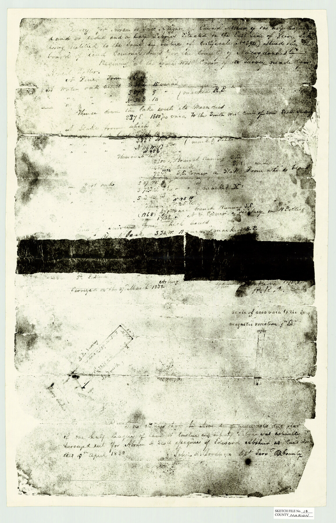
Marion County Sketch File 14
[Field notes of unknown survey in Marion County]
-
Map/Doc
12024
-
Collection
General Map Collection
-
Object Dates
3/27/1838 (Survey Date)
-
People and Organizations
John R. Brodie (Surveyor/Engineer)
-
Counties
Marion
-
Subjects
Surveying Sketch File
-
Height x Width
26.6 x 17.1 inches
67.6 x 43.4 cm
-
Medium
paper, manuscript
-
Scale
1:4000
-
Features
Ferry Lake
Part of: General Map Collection
[Blocks 341, G-5, G-12, TCRRCo.]
![2069, [Blocks 341, G-5, G-12, TCRRCo.], General Map Collection](https://historictexasmaps.com/wmedia_w700/maps/2069-1.tif.jpg)
Print $20.00
- Digital $50.00
[Blocks 341, G-5, G-12, TCRRCo.]
1954
Size 23.7 x 22.7 inches
Map/Doc 2069
Brazoria County NRC Article 33.136 Sketch 21

Print $34.00
Brazoria County NRC Article 33.136 Sketch 21
2018
Map/Doc 97241
Brewster County Sketch File 55

Print $14.00
- Digital $50.00
Brewster County Sketch File 55
1999
Size 10.9 x 6.4 inches
Map/Doc 16385
[Cameron County]
![3365, [Cameron County], General Map Collection](https://historictexasmaps.com/wmedia_w700/maps/3365-2.tif.jpg)
Print $20.00
- Digital $50.00
[Cameron County]
Size 19.2 x 21.8 inches
Map/Doc 3365
Harris County Working Sketch 122

Print $20.00
- Digital $50.00
Harris County Working Sketch 122
1986
Size 30.0 x 40.1 inches
Map/Doc 66014
Hydrography of Sabine Pass and Lake, La. And Tex.

Print $40.00
- Digital $50.00
Hydrography of Sabine Pass and Lake, La. And Tex.
1885
Size 53.2 x 32.5 inches
Map/Doc 2085
Kimble County Rolled Sketch 32

Print $20.00
- Digital $50.00
Kimble County Rolled Sketch 32
1973
Size 23.1 x 19.6 inches
Map/Doc 6522
Liberty County Working Sketch 40

Print $20.00
- Digital $50.00
Liberty County Working Sketch 40
1952
Size 24.1 x 32.9 inches
Map/Doc 70499
El Paso County Boundary File 19

Print $9.00
- Digital $50.00
El Paso County Boundary File 19
Size 13.6 x 8.7 inches
Map/Doc 53206
Blanco County Working Sketch 14

Print $20.00
- Digital $50.00
Blanco County Working Sketch 14
1948
Size 36.2 x 28.8 inches
Map/Doc 67374
Hemphill County Working Sketch 15

Print $20.00
- Digital $50.00
Hemphill County Working Sketch 15
1969
Size 20.2 x 20.0 inches
Map/Doc 66110
Mason County Sketch File 21

Print $6.00
- Digital $50.00
Mason County Sketch File 21
Size 15.7 x 10.9 inches
Map/Doc 30717
You may also like
Childress County Sketch File 12

Print $22.00
- Digital $50.00
Childress County Sketch File 12
Size 13.3 x 8.7 inches
Map/Doc 18255
Gregg County Rolled Sketch 25

Print $40.00
- Digital $50.00
Gregg County Rolled Sketch 25
1933
Size 27.3 x 51.7 inches
Map/Doc 9076
Map of Claude - Claude, Armstrong Co.

Print $20.00
- Digital $50.00
Map of Claude - Claude, Armstrong Co.
Size 46.9 x 38.5 inches
Map/Doc 89743
Orange County Working Sketch 24

Print $20.00
- Digital $50.00
Orange County Working Sketch 24
1941
Size 12.5 x 14.3 inches
Map/Doc 71356
Parker County Boundary File 2

Print $8.00
- Digital $50.00
Parker County Boundary File 2
Size 11.2 x 8.8 inches
Map/Doc 57835
Chambers County Rolled Sketch FD

Print $20.00
- Digital $50.00
Chambers County Rolled Sketch FD
1935
Size 32.7 x 26.5 inches
Map/Doc 5433
Lipscomb County Boundary File 15

Print $44.00
- Digital $50.00
Lipscomb County Boundary File 15
Size 11.3 x 8.7 inches
Map/Doc 56382
No. 2 Chart of Corpus Christi Pass, Texas

Print $20.00
- Digital $50.00
No. 2 Chart of Corpus Christi Pass, Texas
1878
Size 18.2 x 27.1 inches
Map/Doc 73025
Flight Mission No. DAG-23K, Frame 182, Matagorda County

Print $20.00
- Digital $50.00
Flight Mission No. DAG-23K, Frame 182, Matagorda County
1953
Size 18.5 x 22.3 inches
Map/Doc 86517
[Fisher County School Land Lgs. 106-108]
![90198, [Fisher County School Land Lgs. 106-108], Twichell Survey Records](https://historictexasmaps.com/wmedia_w700/maps/90198-1.tif.jpg)
Print $20.00
- Digital $50.00
[Fisher County School Land Lgs. 106-108]
Size 11.7 x 18.4 inches
Map/Doc 90198
Hudspeth County Working Sketch 25

Print $20.00
- Digital $50.00
Hudspeth County Working Sketch 25
1971
Size 24.6 x 28.0 inches
Map/Doc 66307
Northwest Part Crockett County

Print $40.00
- Digital $50.00
Northwest Part Crockett County
1983
Size 38.1 x 48.8 inches
Map/Doc 73121