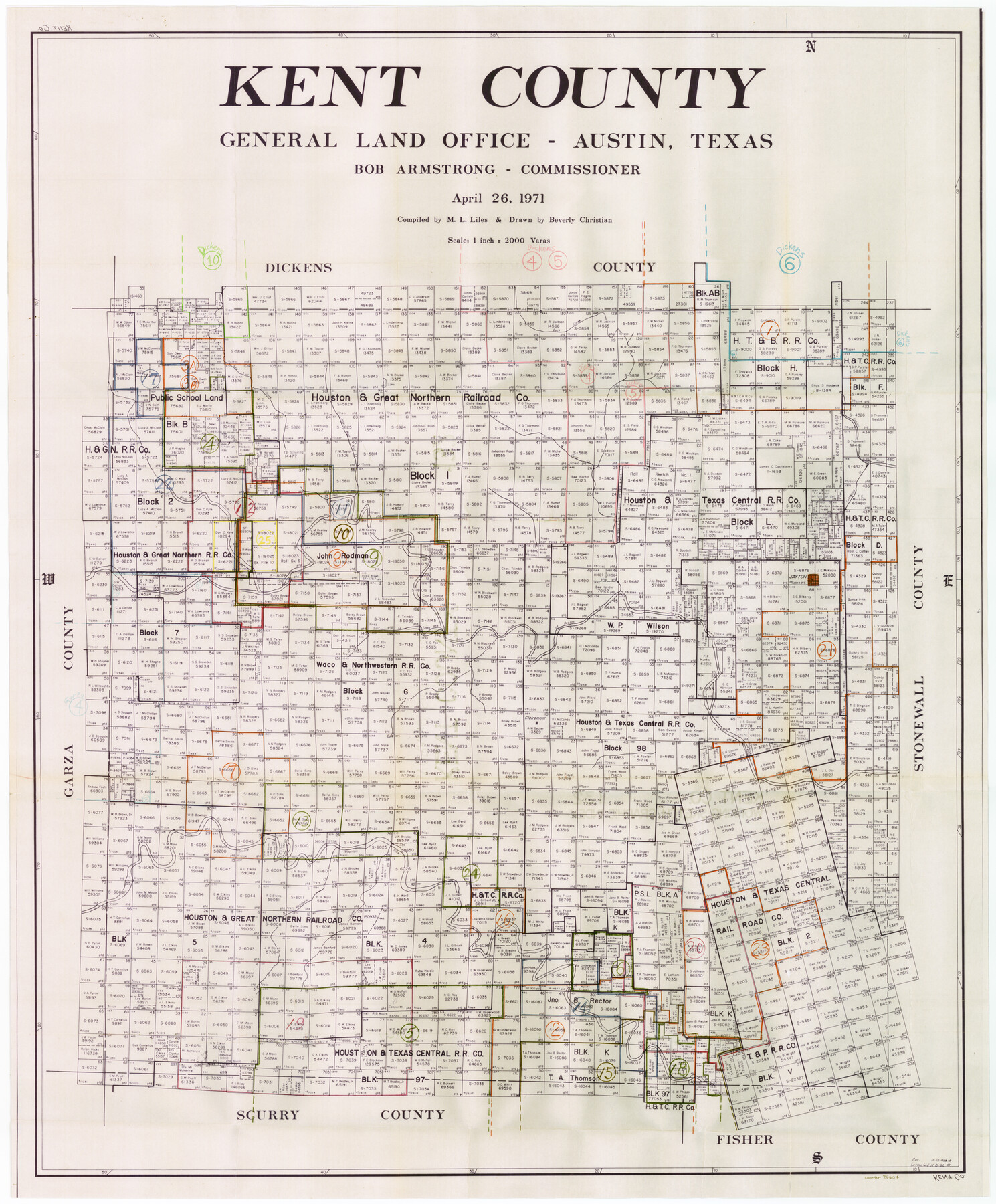
Kent County Working Sketch Graphic Index
-
Map/Doc
76604
-
Collection
General Map Collection
-
Object Dates
4/26/1971 (Creation Date)
-
People and Organizations
M. L. Liles (Compiler)
Beverly Christian (Draftsman)
-
Counties
Kent
-
Subjects
County Surveying Working Sketch
-
Height x Width
44.7 x 37.0 inches
113.5 x 94.0 cm
-
Scale
1" = 2000 varas
Part of: General Map Collection

Midland County Boundary File 2

Print $24.00
- Digital $50.00
Midland County Boundary File 2
Size 8.9 x 5.5 inches
Map/Doc 57162

Van Zandt County

Print $20.00
- Digital $50.00
Van Zandt County
1972
Size 45.8 x 40.1 inches
Map/Doc 77446
[Right of Way Map, Belton Branch of the M.K.&T. RR.]
![64223, [Right of Way Map, Belton Branch of the M.K.&T. RR.], General Map Collection](https://historictexasmaps.com/wmedia_w700/maps/64223.tif.jpg)
Print $20.00
- Digital $50.00
[Right of Way Map, Belton Branch of the M.K.&T. RR.]
1896
Size 21.7 x 7.2 inches
Map/Doc 64223
Lee County Working Sketch 21

Print $40.00
- Digital $50.00
Lee County Working Sketch 21
2009
Size 48.7 x 36.6 inches
Map/Doc 89258
Burleson County Working Sketch 39

Print $20.00
- Digital $50.00
Burleson County Working Sketch 39
1985
Size 15.3 x 18.7 inches
Map/Doc 67758
Stonewall County Sketch File 24

Print $6.00
- Digital $50.00
Stonewall County Sketch File 24
1951
Size 24.8 x 35.2 inches
Map/Doc 12369
Tom Green County Boundary File 4

Print $70.00
- Digital $50.00
Tom Green County Boundary File 4
Size 8.8 x 6.8 inches
Map/Doc 59347
Real County Working Sketch 63

Print $6.00
- Digital $50.00
Real County Working Sketch 63
1967
Size 28.8 x 32.3 inches
Map/Doc 71955
Flight Mission No. DIX-10P, Frame 170, Aransas County

Print $20.00
- Digital $50.00
Flight Mission No. DIX-10P, Frame 170, Aransas County
1956
Size 18.7 x 22.3 inches
Map/Doc 83960

You may also like
Brewster County Rolled Sketch OS

Print $20.00
- Digital $50.00
Brewster County Rolled Sketch OS
Size 17.6 x 21.7 inches
Map/Doc 5323
Outer Continental Shelf Leasing Maps (Texas Offshore Operations)

Print $20.00
- Digital $50.00
Outer Continental Shelf Leasing Maps (Texas Offshore Operations)
Size 24.0 x 18.4 inches
Map/Doc 75853
Real County Working Sketch 90

Print $20.00
- Digital $50.00
Real County Working Sketch 90
1991
Size 16.7 x 22.8 inches
Map/Doc 71982
Flight Mission No. CGI-3N, Frame 139, Cameron County

Print $20.00
- Digital $50.00
Flight Mission No. CGI-3N, Frame 139, Cameron County
1954
Size 18.7 x 22.3 inches
Map/Doc 84612
Zavala County Working Sketch 1

Print $20.00
- Digital $50.00
Zavala County Working Sketch 1
Size 21.2 x 16.3 inches
Map/Doc 62076
Hunt County Sketch File 3

Print $4.00
- Digital $50.00
Hunt County Sketch File 3
1856
Size 6.0 x 8.1 inches
Map/Doc 27085
Jack County Working Sketch 1

Print $20.00
- Digital $50.00
Jack County Working Sketch 1
Size 28.4 x 27.1 inches
Map/Doc 66427
Upton County Sketch File 37

Print $6.00
- Digital $50.00
Upton County Sketch File 37
1953
Size 11.3 x 8.8 inches
Map/Doc 38900
Hamilton County Sketch File 6

Print $6.00
- Digital $50.00
Hamilton County Sketch File 6
Size 15.7 x 10.6 inches
Map/Doc 24910
Jefferson County Sketch File 15a

Print $8.00
- Digital $50.00
Jefferson County Sketch File 15a
1872
Size 15.6 x 6.7 inches
Map/Doc 28156
Midland County Sketch File 13

Print $4.00
- Digital $50.00
Midland County Sketch File 13
1940
Size 11.2 x 8.7 inches
Map/Doc 31576
Guadalupe River, Watershed [of the Guadalupe River]
![65059, Guadalupe River, Watershed [of the Guadalupe River], General Map Collection](https://historictexasmaps.com/wmedia_w700/maps/65059-GC.tif.jpg)
Print $6.00
- Digital $50.00
Guadalupe River, Watershed [of the Guadalupe River]
1925
Size 30.1 x 33.4 inches
Map/Doc 65059