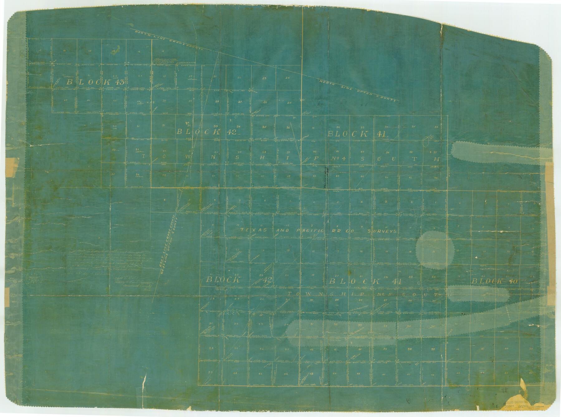
Upton County Rolled Sketch 13
[Sketch of parts of T. & P. Ry. Co. Blocks 40, 41 & 42, Township 5 South & parts of T. & P. Ry. Co. Blocks 41, 42, & 43, Township 4 South in Upton and Crane Counties]
- 
                          Map/Doc10037
- 
                            CollectionGeneral Map Collection
- 
                            Object Dates1926/7/9 (Creation Date)1926/7/14 (File Date)
- 
                            People and OrganizationsRobt. E. Estes (Surveyor/Engineer)
- 
                            CountiesUpton Crane
- 
                            SubjectsSurveying Rolled Sketch
- 
                            Height x Width32.5 x 43.6 inches82.6 x 110.7 cm
- 
                            Mediumblueprint/diazo
Part of: General Map Collection
            Crockett County Rolled Sketch 96


                                            Print $20.00                    
                                             -                         Digital $50.00                                    
                Crockett County Rolled Sketch 96
1986
Size 25.2 x 28.9 inches
                                Map/Doc 5635
            
            Current Miscellaneous File 74


                                            Print $14.00                    
                                             -                         Digital $50.00                                    
                Current Miscellaneous File 74
1850
Size 11.2 x 8.7 inches
                                Map/Doc 74181
            
            Jeff Davis County Sketch File 37


                                            Print $8.00                    
                                             -                         Digital $50.00                                    
                Jeff Davis County Sketch File 37
1953
Size 11.3 x 8.7 inches
                                Map/Doc 28050
            
            Rio Grande Rectification Project, El Paso and Juarez Valley


                                            Print $20.00                    
                                             -                         Digital $50.00                                    
                Rio Grande Rectification Project, El Paso and Juarez Valley
1935
Size 10.7 x 29.6 inches
                                Map/Doc 60862
            
            Armstrong County Working Sketch 8


                                            Print $20.00                    
                                             -                         Digital $50.00                                    
                Armstrong County Working Sketch 8
1902
Size 25.4 x 40.2 inches
                                Map/Doc 67239
            
            Map of Terry County


                                            Print $20.00                    
                                             -                         Digital $50.00                                    
                Map of Terry County
1901
Size 43.1 x 39.8 inches
                                Map/Doc 16892
            
            Wheeler County Boundary File 93


                                            Print $64.00                    
                                             -                         Digital $50.00                                    
                Wheeler County Boundary File 93
Size 9.4 x 5.1 inches
                                Map/Doc 59872
            
            Map of Polk County


                                            Print $20.00                    
                                             -                         Digital $50.00                                    
                Map of Polk County
1879
Size 27.1 x 20.8 inches
                                Map/Doc 3959
            
            Tom Green County Sketch File 82


                                            Print $20.00                    
                                             -                         Digital $50.00                                    
                Tom Green County Sketch File 82
1888
Size 18.5 x 20.9 inches
                                Map/Doc 12454
            
            Wise County Working Sketch 4


                                            Print $20.00                    
                                             -                         Digital $50.00                                    
                Wise County Working Sketch 4
1948
Size 33.2 x 31.5 inches
                                Map/Doc 72618
            
            [Surveys in Austin's Colony along Hickory Creek, Hog Creek, and the Yegua River]
            
                                    ![195, [Surveys in Austin's Colony along Hickory Creek, Hog Creek, and the Yegua River], General Map Collection](https://historictexasmaps.com/wmedia_w700/maps/195.tif.jpg) 


    ![195, [Surveys in Austin's Colony along Hickory Creek, Hog Creek, and the Yegua River], General Map Collection](https://historictexasmaps.com/wmedia_w700/maps/195.tif.jpg) 
                                
            
                                            Print $20.00                    
                                             -                         Digital $50.00                                    
                [Surveys in Austin's Colony along Hickory Creek, Hog Creek, and the Yegua River]
1831
Size 19.4 x 23.9 inches
                                Map/Doc 195
            
            Fayette County Rolled Sketch K


                                            Print $20.00                    
                                             -                         Digital $50.00                                    
                Fayette County Rolled Sketch K
1936
Size 41.2 x 40.0 inches
                                Map/Doc 8886
            You may also like
            Cameron County Rolled Sketch 13


                                            Print $40.00                    
                                             -                         Digital $50.00                                    
                Cameron County Rolled Sketch 13
1952
Size 37.7 x 62.7 inches
                                Map/Doc 61787
            
            Pecos County Sketch File 64


                                            Print $12.00                    
                                             -                         Digital $50.00                                    
                Pecos County Sketch File 64
1919
Size 11.1 x 8.8 inches
                                Map/Doc 33818
            
            Taylor County Working Sketch 6


                                            Print $20.00                    
                                             -                         Digital $50.00                                    
                Taylor County Working Sketch 6
1951
Size 35.4 x 31.9 inches
                                Map/Doc 69616
            
            Flight Mission No. DCL-7C, Frame 147, Kenedy County


                                            Print $20.00                    
                                             -                         Digital $50.00                                    
                Flight Mission No. DCL-7C, Frame 147, Kenedy County
1943
Size 18.3 x 22.4 inches
                                Map/Doc 86104
            
            A Survey of Lake Champlain, including Lake George, Crown Point and St. John


                                            Print $20.00                    
                                             -                         Digital $50.00                                    
                A Survey of Lake Champlain, including Lake George, Crown Point and St. John
1762
Size 29.0 x 20.9 inches
                                Map/Doc 97404
            
            Texas, Matagorda Bay, Vicinity of Trespalacios Bay


                                            Print $40.00                    
                                             -                         Digital $50.00                                    
                Texas, Matagorda Bay, Vicinity of Trespalacios Bay
1933
Size 49.0 x 32.6 inches
                                Map/Doc 69988
            
            Controlled Mosaic by Jack Amman Photogrammetric Engineers, Inc - Sheet 48


                                            Print $20.00                    
                                             -                         Digital $50.00                                    
                Controlled Mosaic by Jack Amman Photogrammetric Engineers, Inc - Sheet 48
1954
Size 20.0 x 24.0 inches
                                Map/Doc 83507
            
            [I. Killough and Hiram Cates surveys and vicinity]
            
                                    ![91851, [I. Killough and Hiram Cates surveys and vicinity], Twichell Survey Records](https://historictexasmaps.com/wmedia_w700/maps/91851-1.tif.jpg) 


    ![91851, [I. Killough and Hiram Cates surveys and vicinity], Twichell Survey Records](https://historictexasmaps.com/wmedia_w700/maps/91851-1.tif.jpg) 
                                
            
                                            Print $20.00                    
                                             -                         Digital $50.00                                    
                [I. Killough and Hiram Cates surveys and vicinity]
Size 27.5 x 9.2 inches
                                Map/Doc 91851
            
            Presidio County Sketch File 81


                                            Print $20.00                    
                                             -                         Digital $50.00                                    
                Presidio County Sketch File 81
1949
Size 47.2 x 21.6 inches
                                Map/Doc 10579
            
            Denton County Sketch File C


                                            Print $10.00                    
                                             -                         Digital $50.00                                    
                Denton County Sketch File C
1882
Size 10.9 x 8.3 inches
                                Map/Doc 20682
            
            [Notes and map showing Public School Land Block K between Yoakum and Terry Counties]
            
                                    ![92010, [Notes and map showing Public School Land Block K between Yoakum and Terry Counties], Twichell Survey Records](https://historictexasmaps.com/wmedia_w700/maps/92010-1.tif.jpg) 


    ![92010, [Notes and map showing Public School Land Block K between Yoakum and Terry Counties], Twichell Survey Records](https://historictexasmaps.com/wmedia_w700/maps/92010-1.tif.jpg) 
                                
            
                                            Print $2.00                    
                                             -                         Digital $50.00                                    
                [Notes and map showing Public School Land Block K between Yoakum and Terry Counties]
Size 8.3 x 5.7 inches
                                Map/Doc 92010
            
            Hemphill County Working Sketch 9


                                            Print $20.00                    
                                             -                         Digital $50.00                                    
                Hemphill County Working Sketch 9
1965
Size 23.0 x 32.8 inches
                                Map/Doc 66104
            