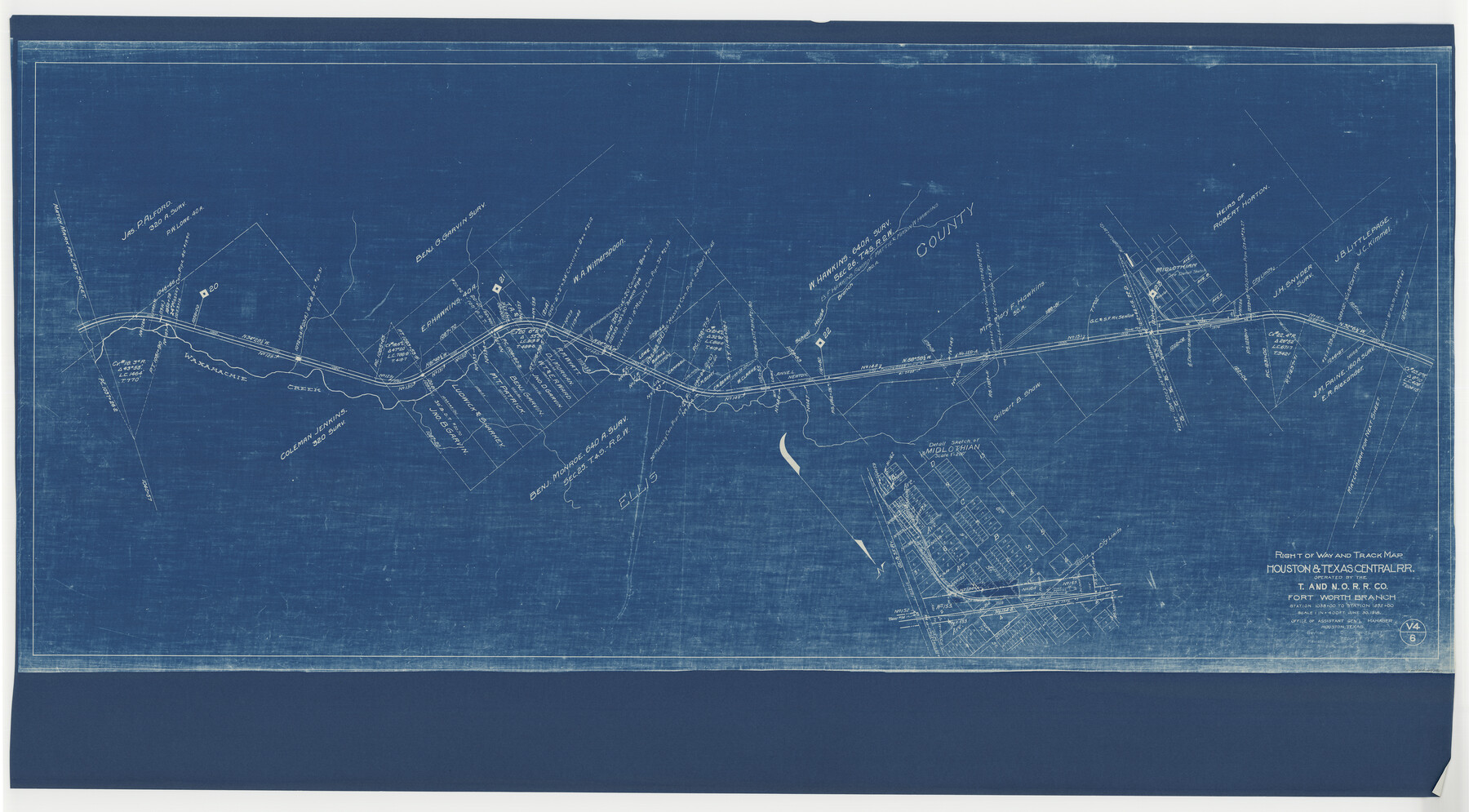
Right of Way and Track Map, Houston & Texas Central R.R. operated by the T. and N. O. R.R., Fort Worth Branch
Station 1038+00 to Station 1252+00
Z-2-164
-
Map/Doc
64780
-
Collection
General Map Collection
-
Object Dates
1927/12/31 (Revision Date)
1930/12/31 (Revision Date)
1918/6/30 (Creation Date)
-
Counties
Tarrant Ellis
-
Subjects
Railroads
-
Height x Width
31.6 x 57.2 inches
80.3 x 145.3 cm
-
Medium
blueprint/diazo
-
Comments
See counter nos. 64539 through 64544, 64779 and 64781 through 64784 for other sheets of the map.
-
Features
H&TC
Midlothian
GC&SF
School House Branch of Waxahachie Creek
Waxahachie Creek
Part of: General Map Collection
Culberson County Rolled Sketch 55

Print $20.00
- Digital $50.00
Culberson County Rolled Sketch 55
1971
Size 22.6 x 17.4 inches
Map/Doc 5676
Map of Anderson County

Print $20.00
- Digital $50.00
Map of Anderson County
1895
Size 40.9 x 45.4 inches
Map/Doc 4784
Galveston Bay Entrance - Galveston and Texas City Harbors

Print $40.00
- Digital $50.00
Galveston Bay Entrance - Galveston and Texas City Harbors
1975
Size 37.4 x 53.5 inches
Map/Doc 69864
Hunt County Sketch File 13

Print $2.00
- Digital $50.00
Hunt County Sketch File 13
1855
Size 12.4 x 8.1 inches
Map/Doc 27106
Roberts County Rolled Sketch 7

Print $20.00
- Digital $50.00
Roberts County Rolled Sketch 7
2018
Size 20.1 x 24.1 inches
Map/Doc 97418
Comal County Sketch File 8 1/2

Print $22.00
- Digital $50.00
Comal County Sketch File 8 1/2
1858
Size 9.2 x 7.4 inches
Map/Doc 19015
Brewster County Sketch File NS-4b

Print $40.00
- Digital $50.00
Brewster County Sketch File NS-4b
Size 30.4 x 35.8 inches
Map/Doc 10988
Flight Mission No. BRE-3P, Frame 79, Nueces County

Print $20.00
- Digital $50.00
Flight Mission No. BRE-3P, Frame 79, Nueces County
1956
Size 18.6 x 22.5 inches
Map/Doc 86820
Hansford County Sketch File 7

Print $4.00
- Digital $50.00
Hansford County Sketch File 7
1927
Size 12.2 x 8.8 inches
Map/Doc 24958
Runnels County Sketch File 19 and 22

Print $48.00
Runnels County Sketch File 19 and 22
1887
Size 14.0 x 21.2 inches
Map/Doc 12254
Map of the country adjacent to the left bank of the Rio Grande below Matamoros

Print $20.00
- Digital $50.00
Map of the country adjacent to the left bank of the Rio Grande below Matamoros
1847
Size 18.3 x 28.2 inches
Map/Doc 72871
Montgomery County Rolled Sketch 44

Print $20.00
- Digital $50.00
Montgomery County Rolled Sketch 44
2004
Size 24.5 x 18.1 inches
Map/Doc 82451
You may also like
Chambers County Rolled Sketch 7

Print $20.00
- Digital $50.00
Chambers County Rolled Sketch 7
Size 39.8 x 23.1 inches
Map/Doc 8611
Survey of the Mexican Lines of Defence at Cerro Gordo, and the lines of attack of the American Army under Major General Scott, on the 17th and 18th of April, 1847

Print $20.00
- Digital $50.00
Survey of the Mexican Lines of Defence at Cerro Gordo, and the lines of attack of the American Army under Major General Scott, on the 17th and 18th of April, 1847
1847
Size 15.3 x 21.6 inches
Map/Doc 95830
Henderson County Rolled Sketch 8

Print $40.00
- Digital $50.00
Henderson County Rolled Sketch 8
1963
Size 37.3 x 50.9 inches
Map/Doc 9164

Cass County Working Sketch 3
Print $20.00
- Digital $50.00
Cass County Working Sketch 3
1936
Size 34.3 x 38.5 inches
Map/Doc 67906
Dickens County Sketch File 8

Print $4.00
- Digital $50.00
Dickens County Sketch File 8
Size 8.8 x 14.2 inches
Map/Doc 20971
Mrs. John H. Dean Ranch, Cochran County, Texas

Print $20.00
- Digital $50.00
Mrs. John H. Dean Ranch, Cochran County, Texas
Size 25.4 x 21.1 inches
Map/Doc 92516
Map of a Part of Lea County, New Mexico

Print $40.00
- Digital $50.00
Map of a Part of Lea County, New Mexico
Size 60.5 x 42.0 inches
Map/Doc 89910
Stonewall County Rolled Sketch 20

Print $40.00
- Digital $50.00
Stonewall County Rolled Sketch 20
1951
Size 30.1 x 55.4 inches
Map/Doc 63915
Bee County Sketch File 25

Print $4.00
- Digital $50.00
Bee County Sketch File 25
1880
Size 11.0 x 8.2 inches
Map/Doc 14326
Presidio County Working Sketch 20

Print $20.00
- Digital $50.00
Presidio County Working Sketch 20
1943
Size 25.6 x 25.5 inches
Map/Doc 71696
Val Verde County Working Sketch 89

Print $20.00
- Digital $50.00
Val Verde County Working Sketch 89
1974
Size 24.5 x 29.0 inches
Map/Doc 72224