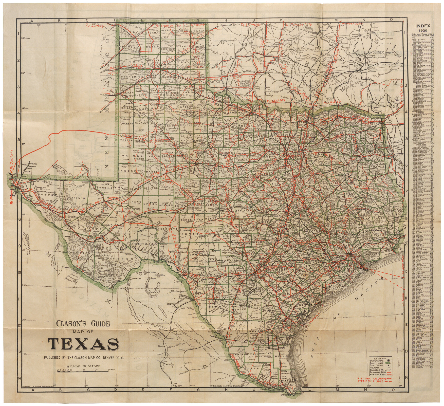
Clason's Guide Map of Texas
-
Map/Doc
95896
-
Collection
Cobb Digital Map Collection
-
Object Dates
1920 (Creation Date)
-
People and Organizations
Clason Map Co. (Publisher)
-
Subjects
Railroads State of Texas
-
Height x Width
20.6 x 22.5 inches
52.3 x 57.2 cm
-
Medium
digital image
-
Comments
Courtesy of John & Diana Cobb.
For map on verso, see 95897. To view full booklet in which this map was contained, click "Download PDF" link above.
Related maps
Oil Map of Texas and Oklahoma showing the location and approximate area of the Oil and Gas Fields

Print $20.00
- Digital $50.00
Oil Map of Texas and Oklahoma showing the location and approximate area of the Oil and Gas Fields
1920
Size 20.8 x 23.9 inches
Map/Doc 95897
Part of: Cobb Digital Map Collection
Due Southwest over the Cotton Belt Route

Due Southwest over the Cotton Belt Route
1891
Map/Doc 96773
Rand, McNally & Co.'s Texas

Print $20.00
- Digital $50.00
Rand, McNally & Co.'s Texas
1901
Size 21.3 x 28.2 inches
Map/Doc 95844

Map of the Houston & Texas Central Railway and connections

Print $20.00
- Digital $50.00
Map of the Houston & Texas Central Railway and connections
1871
Size 16.6 x 15.4 inches
Map/Doc 95753
The MKT - Texas Empire of the South

Print $20.00
- Digital $50.00
The MKT - Texas Empire of the South
1905
Size 18.5 x 40.6 inches
Map/Doc 97035
Map showing Alamo-Donna Farms, Irrigated Section in Hidalgo County, Texas

Print $20.00
- Digital $50.00
Map showing Alamo-Donna Farms, Irrigated Section in Hidalgo County, Texas
1920
Size 27.5 x 13.3 inches
Map/Doc 95803
Galveston The Year-'Round Resort

Galveston The Year-'Round Resort
1912
Size 7.8 x 10.2 inches
Map/Doc 97058
A Geographically Correct County Map of States Traversed by the St. Louis, Iron Mountain and Southern Railway and its connections

Print $20.00
- Digital $50.00
A Geographically Correct County Map of States Traversed by the St. Louis, Iron Mountain and Southern Railway and its connections
1878
Size 16.9 x 27.0 inches
Map/Doc 95785
Summer and Winter Health and Pleasure Resorts

Summer and Winter Health and Pleasure Resorts
1890
Size 7.7 x 5.6 inches
Map/Doc 97076
Rand McNally New Official Railroad Map of the United States and Southern Canada

Print $20.00
- Digital $50.00
Rand McNally New Official Railroad Map of the United States and Southern Canada
1910
Size 29.5 x 40.0 inches
Map/Doc 95860
Appletons' Railway Map of the Southern States, to accompany Appletons' Hand-book of American Travel, Southern Tour

Print $20.00
- Digital $50.00
Appletons' Railway Map of the Southern States, to accompany Appletons' Hand-book of American Travel, Southern Tour
1887
Size 15.6 x 24.3 inches
Map/Doc 95904
Map of Texas with population and location of principal towns and cities according to latest reliable statistics

Print $20.00
- Digital $50.00
Map of Texas with population and location of principal towns and cities according to latest reliable statistics
1909
Size 18.3 x 20.2 inches
Map/Doc 95874
You may also like
Dickens County Sketch File B

Print $4.00
- Digital $50.00
Dickens County Sketch File B
1894
Size 14.2 x 8.8 inches
Map/Doc 20831
[Block V and surrounding surveys]
![90292, [Block V and surrounding surveys], Twichell Survey Records](https://historictexasmaps.com/wmedia_w700/maps/90292-1.tif.jpg)
Print $3.00
- Digital $50.00
[Block V and surrounding surveys]
Size 11.9 x 12.5 inches
Map/Doc 90292
Pecos County Sketch File 21

Print $20.00
- Digital $50.00
Pecos County Sketch File 21
1886
Size 21.6 x 18.5 inches
Map/Doc 12161
Bell County Sketch File 6

Print $4.00
- Digital $50.00
Bell County Sketch File 6
Size 6.3 x 7.7 inches
Map/Doc 14373
Jasper County Working Sketch 29

Print $20.00
- Digital $50.00
Jasper County Working Sketch 29
1956
Size 20.6 x 31.4 inches
Map/Doc 66491
Atascosa County Sketch File 33

Print $40.00
- Digital $50.00
Atascosa County Sketch File 33
1916
Size 24.9 x 19.7 inches
Map/Doc 10865
Controlled Mosaic by Jack Amman Photogrammetric Engineers, Inc - Sheet 25

Print $20.00
- Digital $50.00
Controlled Mosaic by Jack Amman Photogrammetric Engineers, Inc - Sheet 25
1954
Size 20.0 x 24.0 inches
Map/Doc 83476
Coast Chart No. 210 - Aransas Pass and Corpus Christi Bay with the coast to latitude 27° 12', Texas

Print $20.00
- Digital $50.00
Coast Chart No. 210 - Aransas Pass and Corpus Christi Bay with the coast to latitude 27° 12', Texas
1907
Size 44.2 x 36.5 inches
Map/Doc 73449
Map of Throckmorton County Young Land District

Print $20.00
- Digital $50.00
Map of Throckmorton County Young Land District
1859
Size 25.2 x 20.3 inches
Map/Doc 4078
General Highway Map. Detail of Cities and Towns in Dallas County, Texas [Dallas and vicinity]
![79432, General Highway Map. Detail of Cities and Towns in Dallas County, Texas [Dallas and vicinity], Texas State Library and Archives](https://historictexasmaps.com/wmedia_w700/maps/79432.tif.jpg)
Print $20.00
General Highway Map. Detail of Cities and Towns in Dallas County, Texas [Dallas and vicinity]
1961
Size 18.1 x 24.7 inches
Map/Doc 79432
Harrison County Sketch File 3

Print $8.00
- Digital $50.00
Harrison County Sketch File 3
Size 13.0 x 8.3 inches
Map/Doc 26036
Right of Way and Track Map, Galveston, Harrisburg & San Antonio Ry. operated by the T. & N. O. R.R. Co., Victoria Division, Rosenberg to Beeville

Print $40.00
- Digital $50.00
Right of Way and Track Map, Galveston, Harrisburg & San Antonio Ry. operated by the T. & N. O. R.R. Co., Victoria Division, Rosenberg to Beeville
1918
Size 24.4 x 57.9 inches
Map/Doc 76158