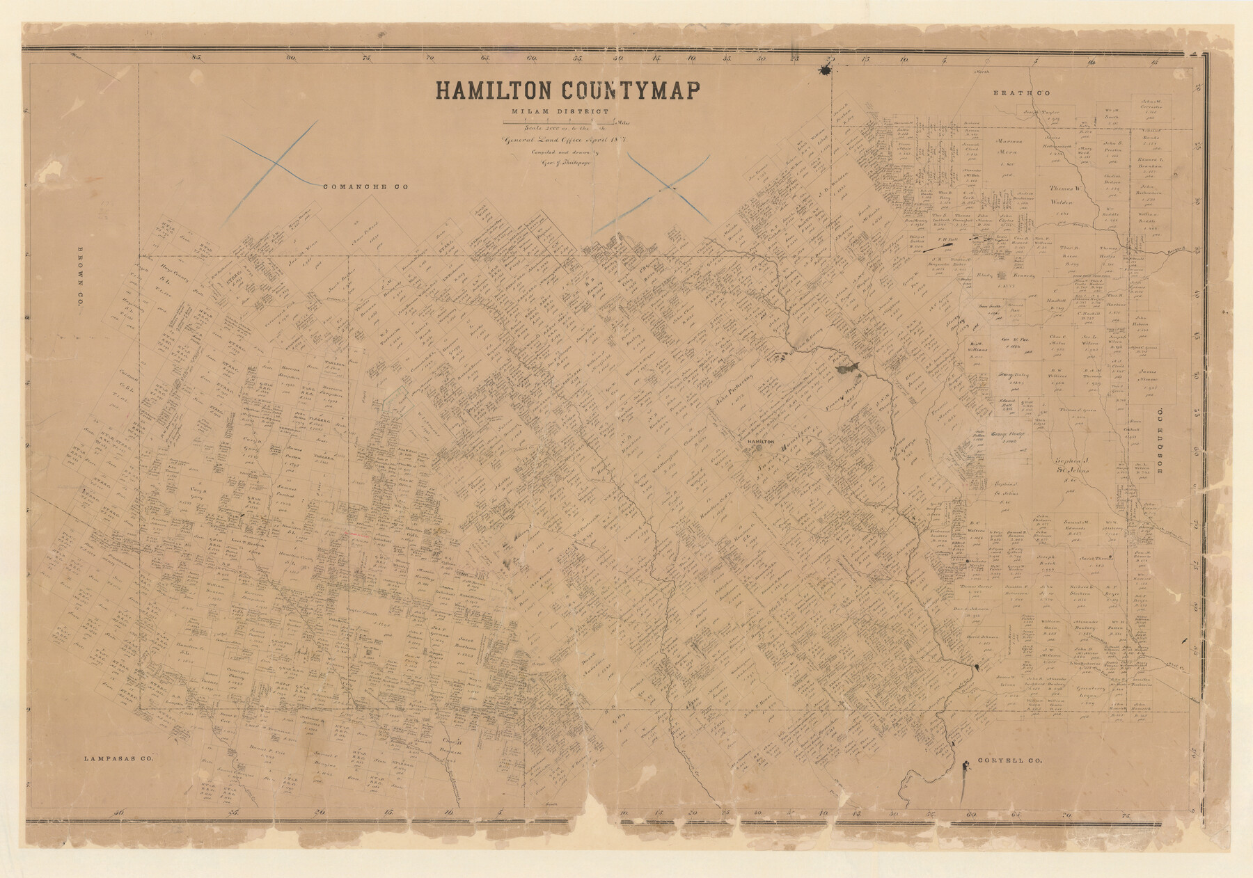
Hamilton County Map
-
Map/Doc
16844
-
Collection
General Map Collection
-
Object Dates
1887 (Creation Date)
-
People and Organizations
Texas General Land Office (Publisher)
George J. Thielepape (Draftsman)
George J. Thielepape (Compiler)
-
Counties
Hamilton
-
Subjects
County
-
Height x Width
38.2 x 54.4 inches
97.0 x 138.2 cm
-
Comments
Conservation funded in 2008 by Friends of the Texas General Land Office.
-
Features
Comanche Creek
Mustang Creek
Sims Creek
Leon River
Plum Creek
Master's Creek
North Fork of Lampasas River
Bennett Creek
Middle Fork [of Neel [sic] Creek]
Neel [sic] Creek
South Fork [of Neel [sic] Creek]
North Fork [of Neel [sic]Creek]
Meridian Creek
Pecan Creek
Cowhouse [sic] Creek
Little Cowhouse [sic] Creek
Gholson Creek
Pardridge [sic] Creek
Goldthwaite
Merrill Creek
Collard Creek
Hamilton
Sycamore Creek
Bear Creek
Bosque River
Honey Creek
Mesquite Creek
Waring's [sic] Creek
Part of: General Map Collection
Sabine and Neches Rivers

Print $20.00
- Digital $50.00
Sabine and Neches Rivers
1925
Size 19.6 x 44.0 inches
Map/Doc 69816
Hale County Rolled Sketch 10

Print $40.00
- Digital $50.00
Hale County Rolled Sketch 10
Size 52.8 x 56.6 inches
Map/Doc 9096
[Surveys in the Bexar District]
![24, [Surveys in the Bexar District], General Map Collection](https://historictexasmaps.com/wmedia_w700/maps/24-1.tif.jpg)
Print $20.00
- Digital $50.00
[Surveys in the Bexar District]
1841
Size 23.0 x 16.5 inches
Map/Doc 24
Real County Sketch File 2

Print $4.00
- Digital $50.00
Real County Sketch File 2
1884
Size 13.4 x 8.5 inches
Map/Doc 35037
Kimble County Sketch File 13

Print $24.00
- Digital $50.00
Kimble County Sketch File 13
1885
Size 14.1 x 8.6 inches
Map/Doc 28937
Motley County Sketch File 20 (S)

Print $14.00
- Digital $50.00
Motley County Sketch File 20 (S)
Size 7.2 x 8.7 inches
Map/Doc 32196
Foard County Working Sketch 6

Print $20.00
- Digital $50.00
Foard County Working Sketch 6
1944
Size 43.4 x 31.4 inches
Map/Doc 69197
Zapata County Sketch File 20

Print $633.00
- Digital $50.00
Zapata County Sketch File 20
1998
Size 11.5 x 8.9 inches
Map/Doc 40966
Roberts County

Print $20.00
- Digital $50.00
Roberts County
1932
Size 41.9 x 38.0 inches
Map/Doc 73275
Travis County Rolled Sketch 49

Print $20.00
- Digital $50.00
Travis County Rolled Sketch 49
Size 43.0 x 39.9 inches
Map/Doc 10017

Stonewall County Rolled Sketch 30

Print $20.00
- Digital $50.00
Stonewall County Rolled Sketch 30
Size 25.5 x 37.3 inches
Map/Doc 7874
You may also like
Crockett County Rolled Sketch RC1

Print $20.00
- Digital $50.00
Crockett County Rolled Sketch RC1
1935
Size 43.7 x 30.6 inches
Map/Doc 8701
Montgomery County Working Sketch 66

Print $20.00
- Digital $50.00
Montgomery County Working Sketch 66
1967
Size 24.7 x 29.0 inches
Map/Doc 71173
Flight Mission No. DAG-21K, Frame 93, Matagorda County

Print $20.00
- Digital $50.00
Flight Mission No. DAG-21K, Frame 93, Matagorda County
1952
Size 18.6 x 22.2 inches
Map/Doc 86422
Kerr County Sketch File 25

Print $4.00
- Digital $50.00
Kerr County Sketch File 25
1873
Size 10.0 x 8.0 inches
Map/Doc 28905
Presidio County Sketch File 39

Print $6.00
- Digital $50.00
Presidio County Sketch File 39
1912
Size 13.3 x 8.9 inches
Map/Doc 34512
Map of Hill County Texas

Print $20.00
- Digital $50.00
Map of Hill County Texas
1886
Size 19.3 x 24.4 inches
Map/Doc 3673
Mitchell County Sketch File 7

Print $20.00
- Digital $50.00
Mitchell County Sketch File 7
1906
Size 19.4 x 12.4 inches
Map/Doc 12096
Wilbarger County Working Sketch 15

Print $20.00
- Digital $50.00
Wilbarger County Working Sketch 15
1955
Size 32.5 x 25.5 inches
Map/Doc 72553
Flight Mission No. CRE-1R, Frame 57, Jackson County

Print $20.00
- Digital $50.00
Flight Mission No. CRE-1R, Frame 57, Jackson County
1956
Size 17.3 x 22.4 inches
Map/Doc 85325
Flight Mission No. CUG-3P, Frame 190, Kleberg County

Print $20.00
- Digital $50.00
Flight Mission No. CUG-3P, Frame 190, Kleberg County
1956
Size 18.6 x 22.4 inches
Map/Doc 86294

[Jones County School Land, Blocks P, D, D6, and CB]
![91091, [Jones County School Land, Blocks P, D, D6, and CB], Twichell Survey Records](https://historictexasmaps.com/wmedia_w700/maps/91091-1.tif.jpg)
Print $2.00
- Digital $50.00
[Jones County School Land, Blocks P, D, D6, and CB]
1907
Size 8.0 x 14.5 inches
Map/Doc 91091