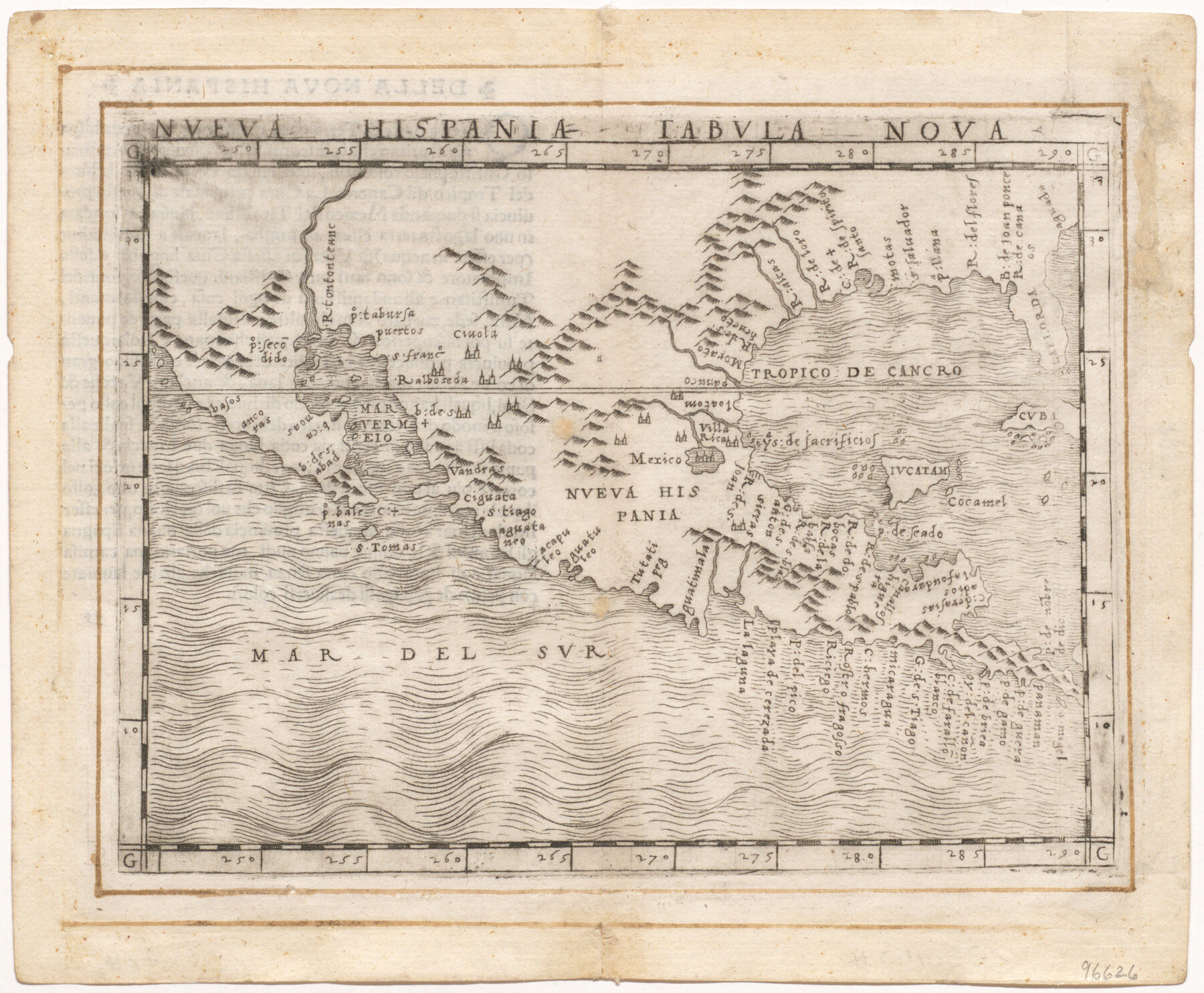
Nueva Hispania Tabula Nova
-
Map/Doc
96626
-
Collection
General Map Collection
-
Object Dates
[1548] (Creation Date)
-
People and Organizations
Giacomo Gastaldi (Cartographer)
-
Subjects
Spanish Texas
-
Height x Width
6.8 x 8.2 inches
17.3 x 20.8 cm
-
Medium
paper, etching/engraving/lithograph
-
Comments
To view text on verso, click the "Download PDF" link above.
Part of: General Map Collection
Fisher County Working Sketch 15

Print $20.00
- Digital $50.00
Fisher County Working Sketch 15
1958
Size 22.2 x 22.6 inches
Map/Doc 69149
Sherman County

Print $20.00
- Digital $50.00
Sherman County
1932
Size 43.1 x 39.9 inches
Map/Doc 63036
Ochiltree County Boundary File 9

Print $18.00
- Digital $50.00
Ochiltree County Boundary File 9
Size 11.2 x 8.7 inches
Map/Doc 57719
Cass County Working Sketch 28

Print $20.00
- Digital $50.00
Cass County Working Sketch 28
1979
Size 16.0 x 16.8 inches
Map/Doc 67931
Calhoun County Rolled Sketch 36

Print $40.00
- Digital $50.00
Calhoun County Rolled Sketch 36
2003
Size 33.3 x 49.0 inches
Map/Doc 78655
Trinity County Working Sketch 19

Print $20.00
- Digital $50.00
Trinity County Working Sketch 19
1982
Size 14.7 x 11.1 inches
Map/Doc 69468
Kerr County Sketch File 12

Print $4.00
- Digital $50.00
Kerr County Sketch File 12
1901
Size 6.7 x 11.1 inches
Map/Doc 28881
[Capitol Leagues in Oldham County]
![4506, [Capitol Leagues in Oldham County], General Map Collection](https://historictexasmaps.com/wmedia_w700/maps/4506-1.tif.jpg)
Print $20.00
- Digital $50.00
[Capitol Leagues in Oldham County]
1918
Size 37.9 x 30.4 inches
Map/Doc 4506
[Surveys along the Trinity River]
![330, [Surveys along the Trinity River], General Map Collection](https://historictexasmaps.com/wmedia_w700/maps/330.tif.jpg)
Print $2.00
- Digital $50.00
[Surveys along the Trinity River]
1846
Size 9.0 x 12.2 inches
Map/Doc 330
United States Gulf Coast - from Galveston to the Rio Grande

Print $20.00
- Digital $50.00
United States Gulf Coast - from Galveston to the Rio Grande
1915
Size 26.4 x 18.2 inches
Map/Doc 72733
Gaines County Working Sketch 8

Print $20.00
- Digital $50.00
Gaines County Working Sketch 8
1951
Size 21.8 x 24.8 inches
Map/Doc 69308
Flight Mission No. DCL-6C, Frame 124, Kenedy County

Print $20.00
- Digital $50.00
Flight Mission No. DCL-6C, Frame 124, Kenedy County
1943
Size 18.6 x 22.4 inches
Map/Doc 85954
You may also like
Galveston County NRC Article 33.136 Sketch 99

Print $26.00
Galveston County NRC Article 33.136 Sketch 99
2024
Map/Doc 97422
Kaufman County Sketch File 3

Print $20.00
- Digital $50.00
Kaufman County Sketch File 3
1857
Size 25.3 x 18.7 inches
Map/Doc 4856
Angelina County Sketch File 18c

Print $4.00
- Digital $50.00
Angelina County Sketch File 18c
Size 12.8 x 8.3 inches
Map/Doc 13034
Copy of a portion of Arista's map

Print $20.00
- Digital $50.00
Copy of a portion of Arista's map
1847
Size 27.5 x 18.3 inches
Map/Doc 73058
Reeves County Rolled Sketch 15

Print $20.00
- Digital $50.00
Reeves County Rolled Sketch 15
1960
Size 21.6 x 25.2 inches
Map/Doc 7484
Map of Jasper County

Print $20.00
- Digital $50.00
Map of Jasper County
1839
Size 40.2 x 28.8 inches
Map/Doc 78407
[Beaumont, Sour Lake and Western Ry. Right of Way and Alignment - Frisco]
![64120, [Beaumont, Sour Lake and Western Ry. Right of Way and Alignment - Frisco], General Map Collection](https://historictexasmaps.com/wmedia_w700/maps/64120.tif.jpg)
Print $20.00
- Digital $50.00
[Beaumont, Sour Lake and Western Ry. Right of Way and Alignment - Frisco]
1910
Size 19.7 x 45.6 inches
Map/Doc 64120
Wilbarger County Working Sketch 5

Print $20.00
- Digital $50.00
Wilbarger County Working Sketch 5
1940
Size 21.3 x 25.6 inches
Map/Doc 72543
Sketch of Surveys in Knox County

Print $20.00
- Digital $50.00
Sketch of Surveys in Knox County
1896
Size 17.6 x 31.2 inches
Map/Doc 75788
[Corner of Blocks H1, K5, Z3, S, and Block 8]
![91470, [Corner of Blocks H1, K5, Z3, S, and Block 8], Twichell Survey Records](https://historictexasmaps.com/wmedia_w700/maps/91470-1.tif.jpg)
Print $3.00
- Digital $50.00
[Corner of Blocks H1, K5, Z3, S, and Block 8]
Size 11.9 x 14.6 inches
Map/Doc 91470
[Working Sketch Showing Southwest Part of the County]
![91117, [Working Sketch Showing Southwest Part of the County], Twichell Survey Records](https://historictexasmaps.com/wmedia_w700/maps/91117-1.tif.jpg)
Print $2.00
- Digital $50.00
[Working Sketch Showing Southwest Part of the County]
1886
Size 14.9 x 9.0 inches
Map/Doc 91117
Brazos River Conservation and Reclamation District Official Boundary Line Survey, Parmer County

Print $20.00
- Digital $50.00
Brazos River Conservation and Reclamation District Official Boundary Line Survey, Parmer County
Size 24.7 x 16.8 inches
Map/Doc 91656