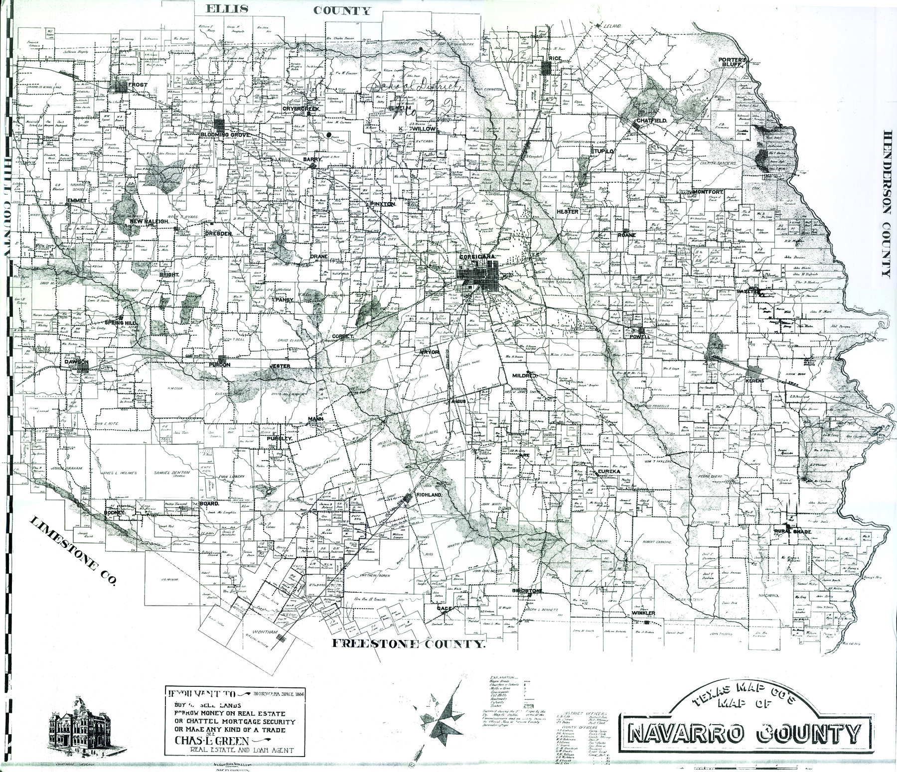
Texas Map Co's Map of Navarro County
-
Map/Doc
96625
-
Collection
Non-GLO Digital Images
-
Object Dates
12/19/1901 (Creation Date)
-
People and Organizations
August Gast Bank Note & Lithograph Company (Lithographer)
-
Counties
Navarro
-
Subjects
County
-
Height x Width
31.3 x 36.3 inches
79.5 x 92.2 cm
-
Medium
digital image
-
Comments
Image provided to the GLO in memory of J.M. Howson.
Part of: Non-GLO Digital Images
Bird's Eye View of Gatesville, Coryell County, Texas

Print $20.00
Bird's Eye View of Gatesville, Coryell County, Texas
1884
Size 15.7 x 24.2 inches
Map/Doc 89088
Waco, Tex., County Seat of McLennan Co.

Print $20.00
Waco, Tex., County Seat of McLennan Co.
1886
Size 23.1 x 32.7 inches
Map/Doc 89212
The Official Map of the City of El Paso, State of Texas

Print $20.00
The Official Map of the City of El Paso, State of Texas
1889
Size 42.1 x 49.6 inches
Map/Doc 89616
Plano del Presidio de Nra. Senora del Pilar de los Adaes, Capital de la Provincia de los Tejas situado en 32 grados y 15 minutos de Latitud Boreal, y en 285° y 52' de Longitud respecto del Meridiano de Tenerife

Plano del Presidio de Nra. Senora del Pilar de los Adaes, Capital de la Provincia de los Tejas situado en 32 grados y 15 minutos de Latitud Boreal, y en 285° y 52' de Longitud respecto del Meridiano de Tenerife
Size 16.9 x 21.4 inches
Map/Doc 96563
Map of Colorado City on the west bank of the Colorado River at the La Bahia crossing

Print $20.00
Map of Colorado City on the west bank of the Colorado River at the La Bahia crossing
1841
Size 24.4 x 32.5 inches
Map/Doc 94750
New Map of the City of New York, with Brooklyn & part of Williamsburg

Print $20.00
- Digital $50.00
New Map of the City of New York, with Brooklyn & part of Williamsburg
1839
Size 14.4 x 12.3 inches
Map/Doc 95909
Bird's Eye View of Bastrop, Bastrop County, Texas

Print $20.00
Bird's Eye View of Bastrop, Bastrop County, Texas
1887
Size 18.8 x 25.7 inches
Map/Doc 89073
El Nuevo Mexico y Tierras Adyacentes Mapa Levantado para la demarcacion de los Limites de los Dominios Españoles y de los Estados Unidos

Print $20.00
El Nuevo Mexico y Tierras Adyacentes Mapa Levantado para la demarcacion de los Limites de los Dominios Españoles y de los Estados Unidos
1811
Size 27.1 x 36.4 inches
Map/Doc 97477
Velasco, Brazoria County, Texas

Print $40.00
Velasco, Brazoria County, Texas
1891
Size 67.2 x 50.5 inches
Map/Doc 77055
Plan of the City of Washington the Capitol of the United States of America

Print $20.00
- Digital $50.00
Plan of the City of Washington the Capitol of the United States of America
1863
Size 12.7 x 15.8 inches
Map/Doc 94475
Bird's Eye View of Cuero, De Witt County, Texas

Print $20.00
Bird's Eye View of Cuero, De Witt County, Texas
1881
Size 18.4 x 25.5 inches
Map/Doc 89079
Plan of New Orleans

Print $20.00
- Digital $50.00
Plan of New Orleans
1860
Size 12.8 x 15.7 inches
Map/Doc 95910
You may also like
Childress Co.

Print $20.00
- Digital $50.00
Childress Co.
1978
Size 47.3 x 36.0 inches
Map/Doc 95454
Hemphill County

Print $20.00
- Digital $50.00
Hemphill County
1932
Size 39.5 x 37.5 inches
Map/Doc 77309
Brazos County Sketch File 2

Print $4.00
- Digital $50.00
Brazos County Sketch File 2
1858
Size 7.9 x 9.4 inches
Map/Doc 15552
Gonzales County Sketch File 4a

Print $4.00
- Digital $50.00
Gonzales County Sketch File 4a
1861
Size 8.0 x 6.7 inches
Map/Doc 24375
San Patricio County NRC Article 33.136 Sketch 10

Print $692.00
San Patricio County NRC Article 33.136 Sketch 10
2023
Map/Doc 97294
Site Development Study for the D. M. Cogdell Memorial Hospital Snyder, Texas

Print $20.00
- Digital $50.00
Site Development Study for the D. M. Cogdell Memorial Hospital Snyder, Texas
Size 24.1 x 26.8 inches
Map/Doc 92922
Rio Vista Annex, An Addition to the City of Lubbock

Print $20.00
- Digital $50.00
Rio Vista Annex, An Addition to the City of Lubbock
1947
Size 19.4 x 12.6 inches
Map/Doc 92754
Flight Mission No. BRA-16M, Frame 52, Jefferson County

Print $20.00
- Digital $50.00
Flight Mission No. BRA-16M, Frame 52, Jefferson County
1953
Size 18.5 x 22.6 inches
Map/Doc 85669
Flight Mission No. DIX-6P, Frame 119, Aransas County

Print $20.00
- Digital $50.00
Flight Mission No. DIX-6P, Frame 119, Aransas County
1956
Size 19.1 x 22.7 inches
Map/Doc 83825
Stonewall County Working Sketch 6

Print $20.00
- Digital $50.00
Stonewall County Working Sketch 6
1949
Size 16.5 x 30.1 inches
Map/Doc 62313
Victoria County Sketch File 6

Print $2.00
- Digital $50.00
Victoria County Sketch File 6
Size 5.3 x 12.5 inches
Map/Doc 39523
Map of Wilbarger County

Print $40.00
- Digital $50.00
Map of Wilbarger County
1887
Size 52.2 x 47.0 inches
Map/Doc 16926