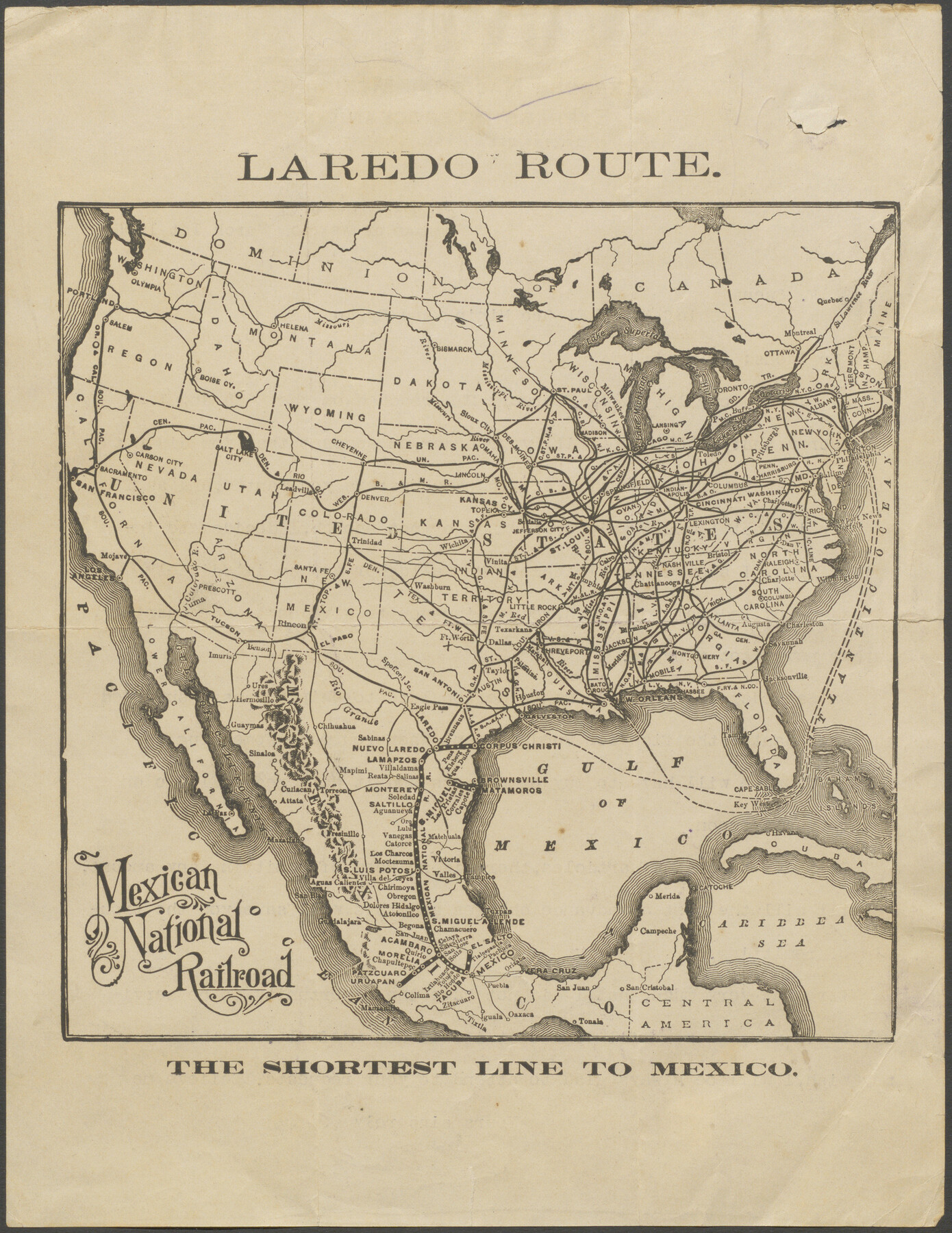
Laredo Route. Mexican National Railroad - the Shortest Line to Mexico
-
Map/Doc
96589
-
Collection
Cobb Digital Map Collection
-
Object Dates
[1905 ca.] (Creation Date)
-
Subjects
Railroads United States
-
Height x Width
11.0 x 8.5 inches
27.9 x 21.6 cm
-
Medium
digital image
-
Comments
Courtesy of John & Diana Cobb.
To view letter on verso, click the "Download PDF" link above.
Part of: Cobb Digital Map Collection
Wright's Special Train between Kansas City and the Panhandle Country

Wright's Special Train between Kansas City and the Panhandle Country
1906
Map/Doc 96752

Sectional map of Texas traversed by the Missouri, Kansas & Texas Railway, showing the crops adapted to each section, with the elevation and annual rainfall

Print $20.00
- Digital $50.00
Sectional map of Texas traversed by the Missouri, Kansas & Texas Railway, showing the crops adapted to each section, with the elevation and annual rainfall
1904
Size 21.7 x 22.6 inches
Map/Doc 95814
Rand, McNally & Co.'s Texas

Print $20.00
- Digital $50.00
Rand, McNally & Co.'s Texas
1887
Size 27.2 x 30.7 inches
Map/Doc 95884
Geological Map of the route explored by Capt. Jno. Pope, Corps of Topl. Engrs. near the 32nd Parallel of North Latitude from the Red River to the Rio Grande

Print $20.00
- Digital $50.00
Geological Map of the route explored by Capt. Jno. Pope, Corps of Topl. Engrs. near the 32nd Parallel of North Latitude from the Red River to the Rio Grande
1854
Size 11.1 x 24.8 inches
Map/Doc 95751
Sectional Map of Texas

Print $20.00
- Digital $50.00
Sectional Map of Texas
1909
Size 21.8 x 23.0 inches
Map/Doc 95799
Southern Homes in Southern Texas, The Celebrated Coast Country

Southern Homes in Southern Texas, The Celebrated Coast Country
1899
Size 6.2 x 3.7 inches
Map/Doc 97050
The Wonderful Lower Rio Grande Valley

Print $20.00
- Digital $50.00
The Wonderful Lower Rio Grande Valley
1909
Size 21.6 x 22.9 inches
Map/Doc 95798
Tourists' Handbook Descriptive of Colorado, New Mexico and Utah

Tourists' Handbook Descriptive of Colorado, New Mexico and Utah
1898
Size 9.4 x 6.4 inches
Map/Doc 97075
Health Wealth and Happiness in the Texas Panhandle

Health Wealth and Happiness in the Texas Panhandle
1906
Map/Doc 96753
Appletons' Railway Map of the Southern States, to accompany Appletons' Hand-book of American Travel, Southern Tour

Print $20.00
- Digital $50.00
Appletons' Railway Map of the Southern States, to accompany Appletons' Hand-book of American Travel, Southern Tour
1887
Size 15.6 x 24.3 inches
Map/Doc 95904
Rand McNally New Official Railroad Map of the United States and Southern Canada

Print $20.00
- Digital $50.00
Rand McNally New Official Railroad Map of the United States and Southern Canada
1910
Size 29.5 x 40.0 inches
Map/Doc 95860
You may also like

University Lands Blocks 29-33, Crockett County, Texas

Print $20.00
- Digital $50.00
University Lands Blocks 29-33, Crockett County, Texas
Size 29.7 x 44.1 inches
Map/Doc 62943
Marion County Working Sketch 12

Print $20.00
- Digital $50.00
Marion County Working Sketch 12
1952
Size 24.5 x 34.2 inches
Map/Doc 70787
Irion County Boundary File 2

Print $60.00
- Digital $50.00
Irion County Boundary File 2
Size 14.3 x 8.9 inches
Map/Doc 55327

Trinity County Rolled Sketch 2

Print $20.00
- Digital $50.00
Trinity County Rolled Sketch 2
1948
Size 34.5 x 34.9 inches
Map/Doc 10024
Galveston County NRC Article 33.136 Location Key Sheet

Print $20.00
- Digital $50.00
Galveston County NRC Article 33.136 Location Key Sheet
1994
Size 27.0 x 21.8 inches
Map/Doc 77019
Llano County Sketch File 20

Print $4.00
- Digital $50.00
Llano County Sketch File 20
1873
Size 12.6 x 8.2 inches
Map/Doc 30405
[Sketch Showing G. H. & H. R.R. Co. Block 3B and A. B. & M. Block M16, Hutchinson County, Texas]
![75813, [Sketch Showing G. H. & H. R.R. Co. Block 3B and A. B. & M. Block M16, Hutchinson County, Texas], Maddox Collection](https://historictexasmaps.com/wmedia_w700/maps/75813.tif.jpg)
Print $20.00
- Digital $50.00
[Sketch Showing G. H. & H. R.R. Co. Block 3B and A. B. & M. Block M16, Hutchinson County, Texas]
Size 20.7 x 21.5 inches
Map/Doc 75813
Hudspeth County Sketch File 33

Print $6.00
- Digital $50.00
Hudspeth County Sketch File 33
1952
Size 11.3 x 8.8 inches
Map/Doc 26994
Morris County Working Sketch 5

Print $20.00
- Digital $50.00
Morris County Working Sketch 5
1965
Size 24.7 x 18.9 inches
Map/Doc 71204
Bowie County Working Sketch 3

Print $20.00
- Digital $50.00
Bowie County Working Sketch 3
1913
Size 25.5 x 17.1 inches
Map/Doc 67407