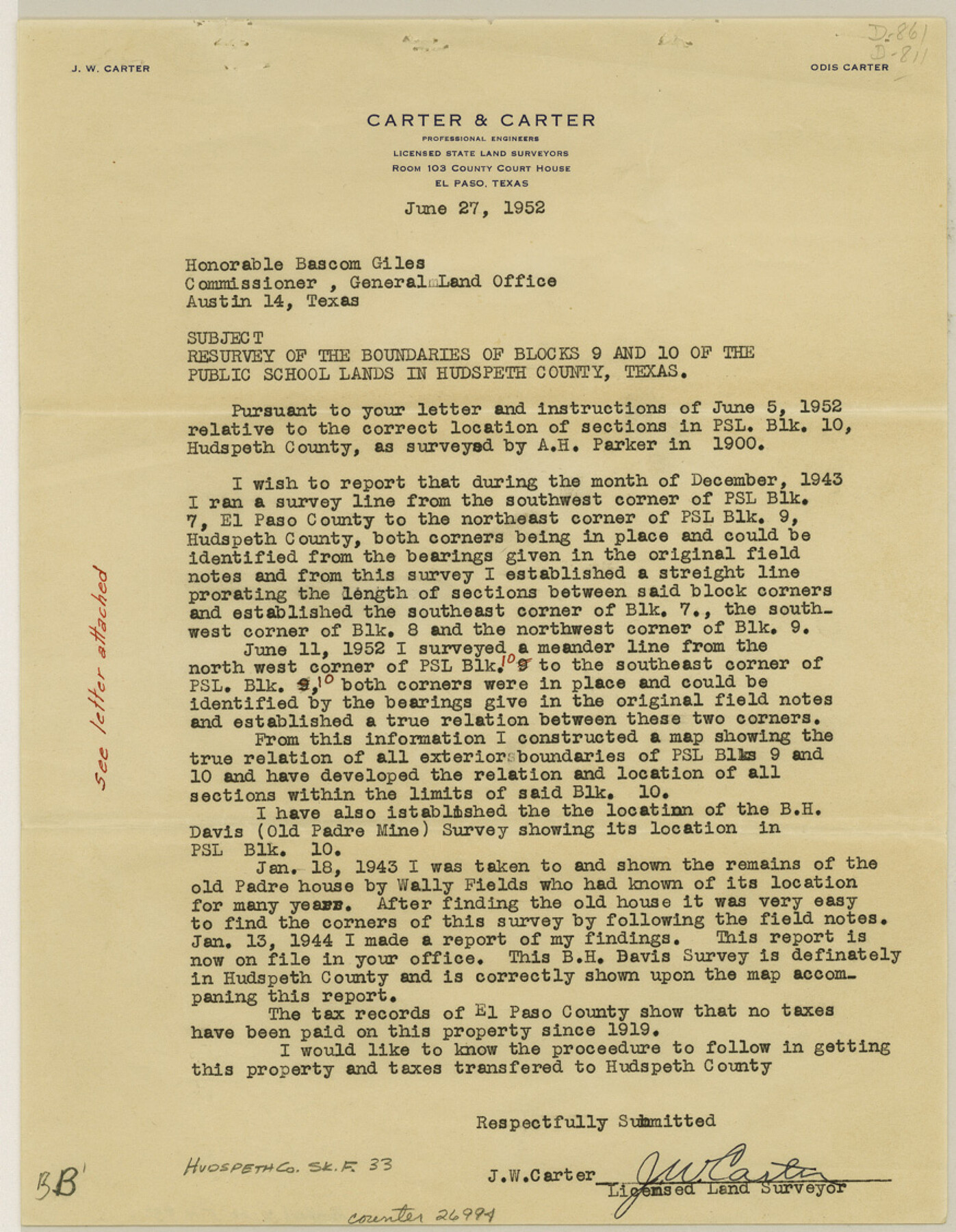
Hudspeth County Sketch File 33
[Report of a resurvey of PSL Blocks 9 and 10 and location of B.H. Davis survey 55]
-
Map/Doc
26994
-
Collection
General Map Collection
-
Object Dates
6/27/1952 (Creation Date)
6/30/1952 (File Date)
6/27/1952 (Correspondence Date)
1900 (Survey Date)
12/1943 (Survey Date)
7/5/1952 (Correspondence Date)
6/11/1952 (Survey Date)
-
People and Organizations
J.W. Carter (Surveyor/Engineer)
A.H. Parker (Surveyor/Engineer)
-
Counties
Hudspeth
-
Subjects
Surveying Sketch File
-
Height x Width
11.3 x 8.8 inches
28.7 x 22.4 cm
-
Medium
paper, print
-
Comments
See Hudspeth County Sketch File 32 (26989) for associated correspondence, and Hudspeth County Rolled Sketch 36 (6249) for sketch.
-
Features
Old Padre Mine
Old Padre House
Related maps
Hudspeth County Sketch File 32

Print $10.00
- Digital $50.00
Hudspeth County Sketch File 32
1952
Size 11.4 x 8.9 inches
Map/Doc 26989
Hudspeth County Rolled Sketch 36

Print $20.00
- Digital $50.00
Hudspeth County Rolled Sketch 36
1952
Size 30.8 x 19.9 inches
Map/Doc 6249
Part of: General Map Collection
Pecos County Working Sketch 51

Print $20.00
- Digital $50.00
Pecos County Working Sketch 51
1948
Size 22.5 x 21.9 inches
Map/Doc 71523
Plan of the Battle of Buena-Vista fought February 22nd and 23rd, 1847

Print $20.00
- Digital $50.00
Plan of the Battle of Buena-Vista fought February 22nd and 23rd, 1847
1847
Size 17.6 x 21.6 inches
Map/Doc 95829
Denton County Working Sketch 26

Print $20.00
- Digital $50.00
Denton County Working Sketch 26
1995
Size 29.3 x 33.9 inches
Map/Doc 68631
Nueces County Rolled Sketch 123

Print $20.00
- Digital $50.00
Nueces County Rolled Sketch 123
1997
Size 18.2 x 24.9 inches
Map/Doc 7158
Polk County Sketch File 26

Print $12.00
- Digital $50.00
Polk County Sketch File 26
1889
Size 8.5 x 7.1 inches
Map/Doc 34183
Flight Mission No. DQN-7K, Frame 14, Calhoun County

Print $20.00
- Digital $50.00
Flight Mission No. DQN-7K, Frame 14, Calhoun County
1953
Size 17.2 x 19.1 inches
Map/Doc 84465
[Map of Val Verde County]
![4110, [Map of Val Verde County], General Map Collection](https://historictexasmaps.com/wmedia_w700/maps/4110-1.tif.jpg)
Print $20.00
- Digital $50.00
[Map of Val Verde County]
1931
Size 36.4 x 24.1 inches
Map/Doc 4110
Robertson County Working Sketch Graphic Index

Print $20.00
- Digital $50.00
Robertson County Working Sketch Graphic Index
1945
Size 46.8 x 37.9 inches
Map/Doc 76685
Flight Mission No. CLL-4N, Frame 39, Willacy County

Print $20.00
- Digital $50.00
Flight Mission No. CLL-4N, Frame 39, Willacy County
1954
Size 18.3 x 22.0 inches
Map/Doc 87112
Houston Ship Channel
Print $20.00
- Digital $50.00
Houston Ship Channel
1926
Size 32.9 x 38.3 inches
Map/Doc 69893
Archer County Working Sketch 4

Print $40.00
- Digital $50.00
Archer County Working Sketch 4
1918
Size 49.9 x 68.3 inches
Map/Doc 67144
Calhoun County NRC Article 33.136 Sketch 3

Print $40.00
- Digital $50.00
Calhoun County NRC Article 33.136 Sketch 3
2000
Size 24.4 x 36.5 inches
Map/Doc 81914
You may also like
Flight Mission No. DQN-2K, Frame 76, Calhoun County

Print $20.00
- Digital $50.00
Flight Mission No. DQN-2K, Frame 76, Calhoun County
1953
Size 18.8 x 22.3 inches
Map/Doc 84268
Wharton County Sketch File 3

Print $4.00
- Digital $50.00
Wharton County Sketch File 3
1875
Size 9.1 x 8.3 inches
Map/Doc 39915
Jefferson County

Print $20.00
- Digital $50.00
Jefferson County
1882
Size 22.8 x 20.0 inches
Map/Doc 3730
Plano General de la Ciudad de Mexico. Levantado Por el Teniente Coronel Don Diego Garcia Conde en el Año de 1793. Aumentado y corregido en lo mas notable Por el Teniente Coronel retirado, Don Rafael Maria Calvo En el de 1830

Print $20.00
- Digital $50.00
Plano General de la Ciudad de Mexico. Levantado Por el Teniente Coronel Don Diego Garcia Conde en el Año de 1793. Aumentado y corregido en lo mas notable Por el Teniente Coronel retirado, Don Rafael Maria Calvo En el de 1830
1793
Size 19.7 x 21.8 inches
Map/Doc 95354
Hemphill County

Print $20.00
- Digital $50.00
Hemphill County
1878
Size 19.1 x 16.9 inches
Map/Doc 3661
[Right of Way & Track Map, The Texas & Pacific Ry. Co. Main Line]
![64691, [Right of Way & Track Map, The Texas & Pacific Ry. Co. Main Line], General Map Collection](https://historictexasmaps.com/wmedia_w700/maps/64691.tif.jpg)
Print $20.00
- Digital $50.00
[Right of Way & Track Map, The Texas & Pacific Ry. Co. Main Line]
Size 10.9 x 18.6 inches
Map/Doc 64691
Grimes County Working Sketch 7

Print $20.00
- Digital $50.00
Grimes County Working Sketch 7
1963
Size 27.2 x 33.0 inches
Map/Doc 63298
Pecos County Rolled Sketch 105

Print $20.00
- Digital $50.00
Pecos County Rolled Sketch 105
1940
Size 30.7 x 37.7 inches
Map/Doc 9717
Upshur County Working Sketch 11

Print $20.00
- Digital $50.00
Upshur County Working Sketch 11
1976
Size 43.4 x 43.2 inches
Map/Doc 69568
Lynn County Rolled Sketch 16

Print $20.00
- Digital $50.00
Lynn County Rolled Sketch 16
1991
Size 18.3 x 42.3 inches
Map/Doc 6652
Zavala County Sketch File 10a

Print $6.00
- Digital $50.00
Zavala County Sketch File 10a
1885
Size 14.6 x 8.8 inches
Map/Doc 41267
Travis County Sketch File 35

Print $2.00
- Digital $50.00
Travis County Sketch File 35
Size 10.8 x 8.3 inches
Map/Doc 38354