Trinity County Rolled Sketch 2
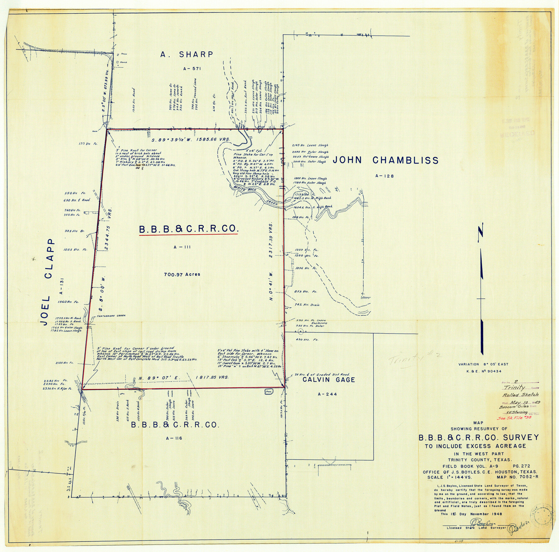
Map showing resurvey of B. B. B. & C. R.R. Co. survey to include excess acreage in the west part Trinity County, Texas
-
Map/Doc
10024
-
Collection
General Map Collection
-
Object Dates
1948/11/1 (Creation Date)
1949/5/10 (File Date)
-
People and Organizations
J.S. Boyles (Surveyor/Engineer)
-
Counties
Trinity
-
Subjects
Surveying Rolled Sketch
-
Height x Width
34.5 x 34.9 inches
87.6 x 88.6 cm
-
Medium
blueprint/diazo
-
Scale
1" = 144 varas
-
Comments
See Trinity County Sketch File 38 (38593) for report.
Related maps
Trinity County Sketch File 38

Print $8.00
- Digital $50.00
Trinity County Sketch File 38
1948
Size 14.5 x 8.9 inches
Map/Doc 38593
Part of: General Map Collection
Upton County Working Sketch 50

Print $20.00
- Digital $50.00
Upton County Working Sketch 50
1980
Size 19.5 x 21.4 inches
Map/Doc 69547
Gillespie County Working Sketch 3

Print $20.00
- Digital $50.00
Gillespie County Working Sketch 3
1960
Size 23.0 x 21.7 inches
Map/Doc 63166
Wharton County Working Sketch 24

Print $20.00
- Digital $50.00
Wharton County Working Sketch 24
1909
Size 13.3 x 14.2 inches
Map/Doc 72488
Bastrop County Working Sketch 15

Print $20.00
- Digital $50.00
Bastrop County Working Sketch 15
1993
Size 23.5 x 21.1 inches
Map/Doc 67315
Galveston County Rolled Sketch 44

Print $20.00
- Digital $50.00
Galveston County Rolled Sketch 44
1991
Size 24.9 x 36.9 inches
Map/Doc 5973
Flight Mission No. DQO-1K, Frame 150, Galveston County

Print $20.00
- Digital $50.00
Flight Mission No. DQO-1K, Frame 150, Galveston County
1952
Size 19.1 x 22.6 inches
Map/Doc 85003
Angelina County Sketch File 11c

Print $7.00
- Digital $50.00
Angelina County Sketch File 11c
Size 11.1 x 6.0 inches
Map/Doc 12946
Burnet County Sketch File 42

Print $28.00
- Digital $50.00
Burnet County Sketch File 42
1950
Size 9.9 x 8.8 inches
Map/Doc 16760
Wheeler County Sketch File 7

Print $20.00
- Digital $50.00
Wheeler County Sketch File 7
Size 38.1 x 47.7 inches
Map/Doc 10431
Kent County Rolled Sketch A

Print $20.00
- Digital $50.00
Kent County Rolled Sketch A
1902
Size 23.9 x 36.8 inches
Map/Doc 6477
Dallas, Texas

Print $20.00
- Digital $50.00
Dallas, Texas
1890
Size 14.8 x 11.7 inches
Map/Doc 94085
University Land Field Notes for Blocks 39, 41, 42, 44, 45, 46, 47, 50, and 51 in Crockett County, Blocks 38 and 40 in Crockett and Irion Counties, and Blocks 48 and 49 in Crockett and Reagan Counties, and Block 43 in Crockett, Irion, and Reagan Counties

University Land Field Notes for Blocks 39, 41, 42, 44, 45, 46, 47, 50, and 51 in Crockett County, Blocks 38 and 40 in Crockett and Irion Counties, and Blocks 48 and 49 in Crockett and Reagan Counties, and Block 43 in Crockett, Irion, and Reagan Counties
Map/Doc 81718
You may also like
[County Line, Roberts and Hutchinson County]
![91184, [County Line, Roberts and Hutchinson County], Twichell Survey Records](https://historictexasmaps.com/wmedia_w700/maps/91184-1.tif.jpg)
Print $20.00
- Digital $50.00
[County Line, Roberts and Hutchinson County]
1907
Size 33.7 x 7.7 inches
Map/Doc 91184
General Highway Map. Detail of Cities and Towns in Bastrop County, Texas [Bastrop, Smithville, Elgin, etc.]
![79362, General Highway Map. Detail of Cities and Towns in Bastrop County, Texas [Bastrop, Smithville, Elgin, etc.], Texas State Library and Archives](https://historictexasmaps.com/wmedia_w700/maps/79362.tif.jpg)
Print $20.00
General Highway Map. Detail of Cities and Towns in Bastrop County, Texas [Bastrop, Smithville, Elgin, etc.]
1961
Size 18.3 x 25.0 inches
Map/Doc 79362
Geographical, Statistical, and Historical Map of Arkansas Territory

Print $20.00
- Digital $50.00
Geographical, Statistical, and Historical Map of Arkansas Territory
1822
Size 17.9 x 21.9 inches
Map/Doc 95713
Presidio County Sketch File 62

Print $10.00
- Digital $50.00
Presidio County Sketch File 62
1938
Size 11.2 x 8.8 inches
Map/Doc 34647
[Movements & Objectives of the 143rd & 144th Infantry on October 13, 1918, Appendix L]
![94124, [Movements & Objectives of the 143rd & 144th Infantry on October 13, 1918, Appendix L], Non-GLO Digital Images](https://historictexasmaps.com/wmedia_w700/maps/94124-1.tif.jpg)
Print $20.00
[Movements & Objectives of the 143rd & 144th Infantry on October 13, 1918, Appendix L]
1918
Size 16.1 x 16.8 inches
Map/Doc 94124
Borden County Sketch File 12

Print $24.00
- Digital $50.00
Borden County Sketch File 12
Size 10.8 x 9.1 inches
Map/Doc 14732
Randall County Boundary File 2a

Print $14.00
- Digital $50.00
Randall County Boundary File 2a
Size 9.6 x 6.1 inches
Map/Doc 58118
General Highway Map, Montague County, Texas

Print $20.00
General Highway Map, Montague County, Texas
1940
Size 24.9 x 18.3 inches
Map/Doc 79201
The Republic County of Colorado. December 29, 1845

Print $20.00
The Republic County of Colorado. December 29, 1845
2020
Size 18.4 x 21.7 inches
Map/Doc 96127
In the Supreme Court of the United States, The State of Oklahoma, Complainant vs. The State of Texas, Defendant, The United States of America, Intervener, Red River Valley, Texas and Oklahoma Between the 98th and 100th Meridians in Five Sheets, 1921

Print $40.00
- Digital $50.00
In the Supreme Court of the United States, The State of Oklahoma, Complainant vs. The State of Texas, Defendant, The United States of America, Intervener, Red River Valley, Texas and Oklahoma Between the 98th and 100th Meridians in Five Sheets, 1921
1921
Size 37.1 x 60.6 inches
Map/Doc 75278

[Sketch showing surveys in the north half of Potter County, Blocks 1, 6-T, 25, B-10, B-12, O-18, P and Mc, and H. & T. C., Block 44]
![91742, [Sketch showing surveys in the north half of Potter County, Blocks 1, 6-T, 25, B-10, B-12, O-18, P and Mc, and H. & T. C., Block 44], Twichell Survey Records](https://historictexasmaps.com/wmedia_w700/maps/91742-1.tif.jpg)
Print $20.00
- Digital $50.00
[Sketch showing surveys in the north half of Potter County, Blocks 1, 6-T, 25, B-10, B-12, O-18, P and Mc, and H. & T. C., Block 44]
Size 40.4 x 17.7 inches
Map/Doc 91742