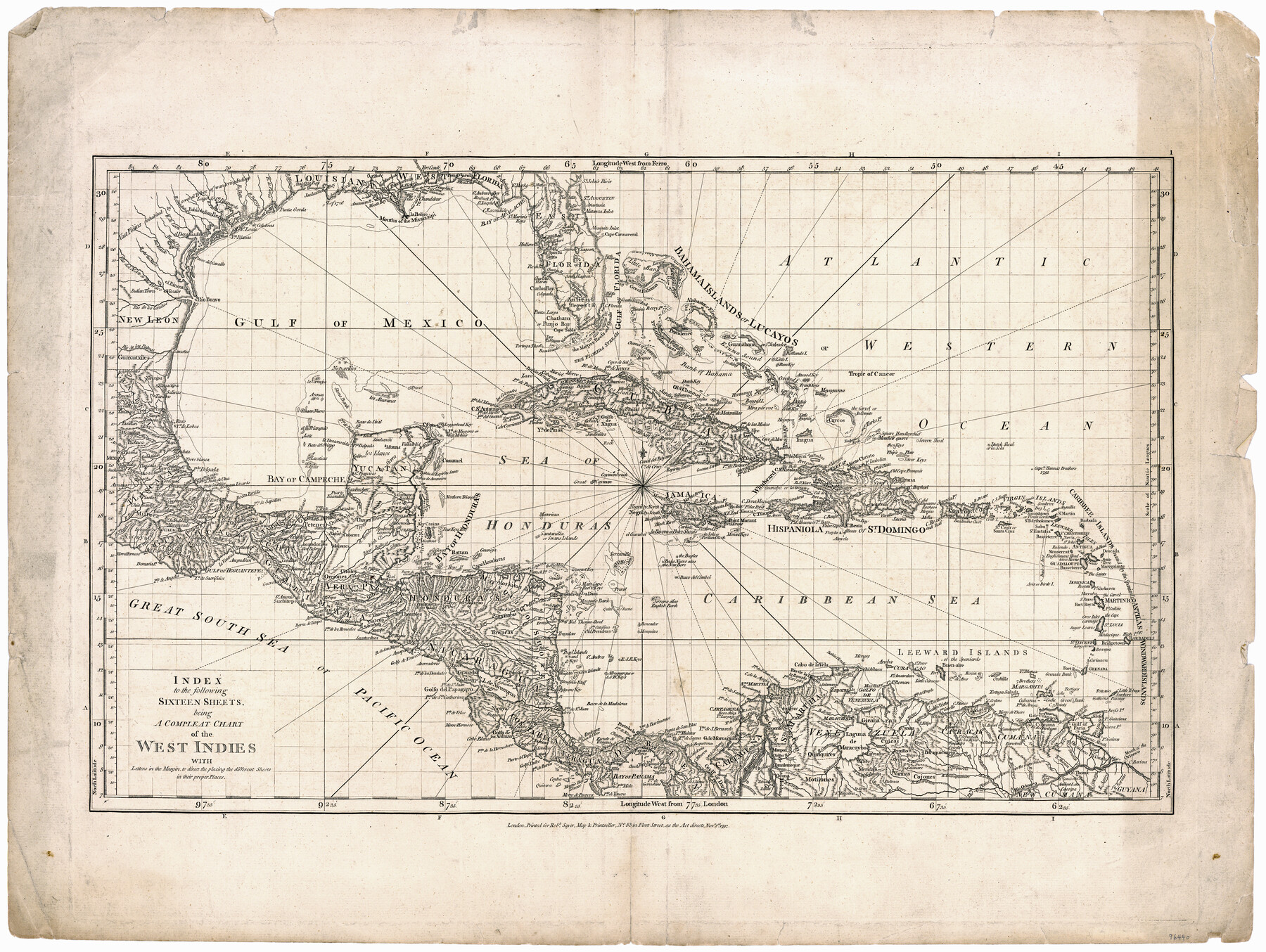
Index to the following sixteen sheets, being a compleat chart of the West Indies with letters in the margin to direct the placing of the different sheets in their proper places
-
Map/Doc
96440
-
Collection
General Map Collection
-
Object Dates
1792/11/1 (Publication Date)
-
People and Organizations
Robert Sayer (Publisher)
-
Subjects
Central America Gulf of Mexico
-
Height x Width
21.5 x 28.6 inches
54.6 x 72.6 cm
-
Medium
paper, etching/engraving/lithograph
-
Comments
This map is the index map that served as the key sheet for joining the maps from Jefferys West India Atlas to create a single wall map.
Part of: General Map Collection
Hamilton County Working Sketch 18

Print $20.00
- Digital $50.00
Hamilton County Working Sketch 18
1952
Size 22.4 x 25.1 inches
Map/Doc 63356
Bell County Sketch File 30

Print $4.00
- Digital $50.00
Bell County Sketch File 30
1876
Size 10.1 x 8.0 inches
Map/Doc 14443
Potter County Working Sketch 2

Print $40.00
- Digital $50.00
Potter County Working Sketch 2
1919
Size 43.3 x 54.4 inches
Map/Doc 71662
Concho County Sketch File 16

Print $20.00
- Digital $50.00
Concho County Sketch File 16
Size 8.2 x 18.6 inches
Map/Doc 11151
Map of Nacogdoches County

Print $40.00
- Digital $50.00
Map of Nacogdoches County
1896
Size 64.0 x 59.7 inches
Map/Doc 16776
Map of the Straits of Florida and Gulf of Mexico

Print $20.00
- Digital $50.00
Map of the Straits of Florida and Gulf of Mexico
1851
Size 18.3 x 27.5 inches
Map/Doc 72676
Flight Mission No. BQR-5K, Frame 72, Brazoria County

Print $20.00
- Digital $50.00
Flight Mission No. BQR-5K, Frame 72, Brazoria County
1952
Size 18.9 x 22.4 inches
Map/Doc 84017
Flight Mission No. DQN-3K, Frame 5, Calhoun County

Print $20.00
- Digital $50.00
Flight Mission No. DQN-3K, Frame 5, Calhoun County
1953
Size 18.4 x 22.1 inches
Map/Doc 84337
Crane County Working Sketch 3

Print $20.00
- Digital $50.00
Crane County Working Sketch 3
1924
Size 36.2 x 34.4 inches
Map/Doc 68280
Flight Mission No. BRA-6M, Frame 74, Jefferson County

Print $20.00
- Digital $50.00
Flight Mission No. BRA-6M, Frame 74, Jefferson County
1953
Size 18.6 x 22.3 inches
Map/Doc 85418
Swisher County Working Sketch 2

Print $20.00
- Digital $50.00
Swisher County Working Sketch 2
1950
Size 21.5 x 21.7 inches
Map/Doc 62413
Rusk County Sketch File 27a

Print $10.00
Rusk County Sketch File 27a
1936
Size 14.2 x 8.8 inches
Map/Doc 35532
You may also like
Harris County Working Sketch 87

Print $20.00
- Digital $50.00
Harris County Working Sketch 87
1972
Size 34.1 x 31.0 inches
Map/Doc 65979
Crockett County Sketch File 23

Print $2.00
- Digital $50.00
Crockett County Sketch File 23
Size 8.6 x 8.5 inches
Map/Doc 19697
Maps of Gulf Intracoastal Waterway, Texas - Sabine River to the Rio Grande and connecting waterways including ship channels

Print $20.00
- Digital $50.00
Maps of Gulf Intracoastal Waterway, Texas - Sabine River to the Rio Grande and connecting waterways including ship channels
1966
Size 14.6 x 22.2 inches
Map/Doc 61958
Nueces County Rolled Sketch 70

Print $60.00
Nueces County Rolled Sketch 70
1980
Size 25.3 x 38.0 inches
Map/Doc 6921
[Area around Gillespie County, Bastrop County and El Paso County School Land Leagues]
![90866, [Area around Gillespie County, Bastrop County and El Paso County School Land Leagues], Twichell Survey Records](https://historictexasmaps.com/wmedia_w700/maps/90866-2.tif.jpg)
Print $20.00
- Digital $50.00
[Area around Gillespie County, Bastrop County and El Paso County School Land Leagues]
1886
Size 25.7 x 29.8 inches
Map/Doc 90866
Eastland County Sketch File 3

Print $4.00
- Digital $50.00
Eastland County Sketch File 3
1860
Size 10.2 x 8.3 inches
Map/Doc 21566
Runnels County Sketch File 13

Print $2.00
Runnels County Sketch File 13
Size 8.0 x 6.2 inches
Map/Doc 35456
Hopkins County Sketch File 9

Print $6.00
- Digital $50.00
Hopkins County Sketch File 9
1856
Size 12.8 x 8.3 inches
Map/Doc 26697
Rains County Boundary File 1

Print $6.00
- Digital $50.00
Rains County Boundary File 1
Size 11.3 x 8.8 inches
Map/Doc 58090
Guadalupe County Sketch File 2

Print $4.00
- Digital $50.00
Guadalupe County Sketch File 2
1848
Size 9.4 x 8.3 inches
Map/Doc 24648
Map of Coleman County

Print $20.00
- Digital $50.00
Map of Coleman County
1895
Size 26.1 x 18.9 inches
Map/Doc 3415
Presidio County Sketch File 117

Print $26.00
- Digital $50.00
Presidio County Sketch File 117
1994
Size 14.3 x 8.8 inches
Map/Doc 34906