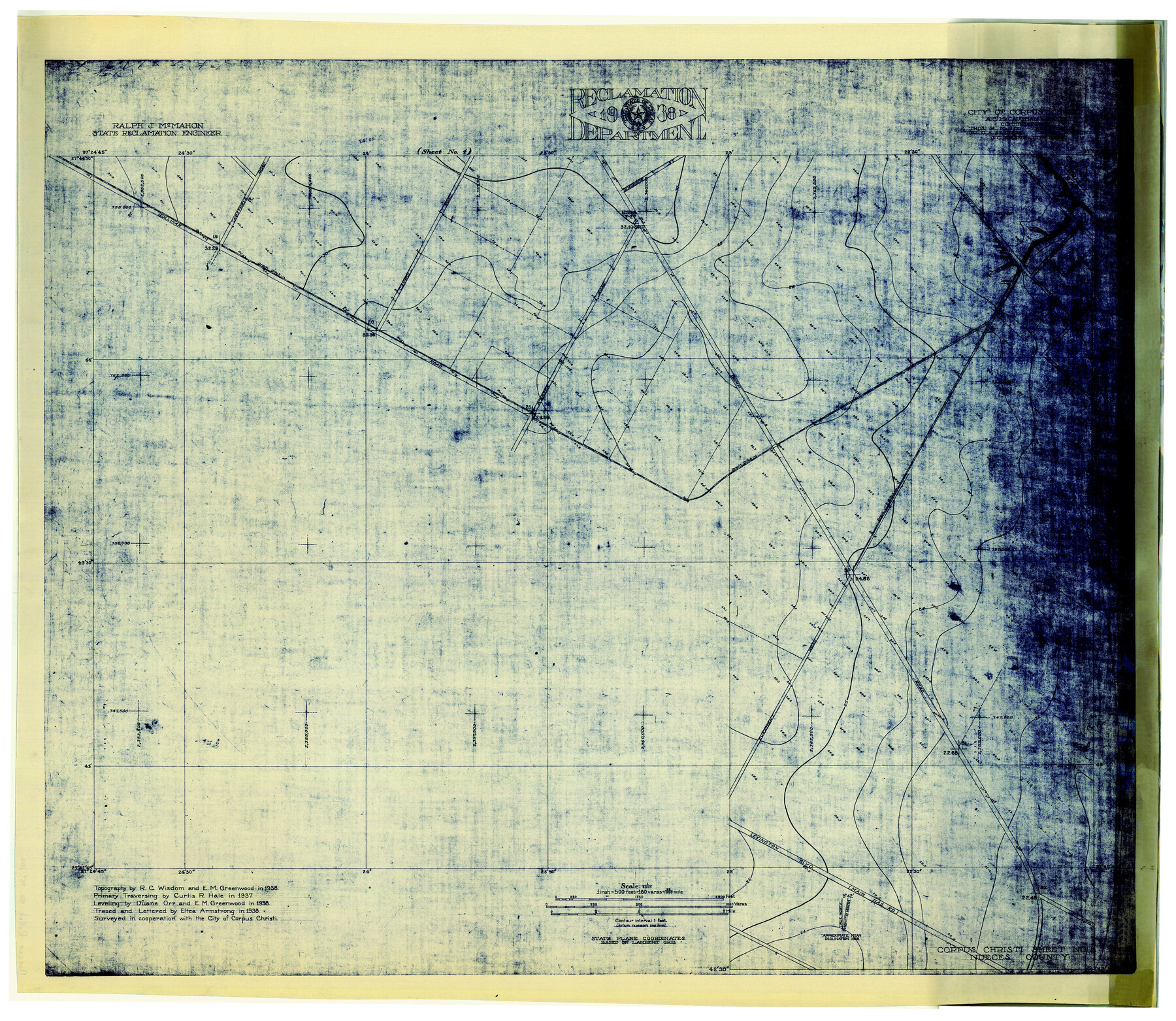
Nueces County Rolled Sketch 100
[State Reclamation Department map - Corpus Christi sheet]
-
Map/Doc
9634
-
Collection
General Map Collection
-
Object Dates
1937 (Creation Date)
1985 (File Date)
-
People and Organizations
Curtis R. Hale (Surveyor/Engineer)
R.C. Wisdom (Surveyor/Engineer)
Eltea Armstrong (Letterer)
E.M. Greenwood (Surveyor/Engineer)
Duane Orr (Surveyor/Engineer)
-
Counties
Nueces
-
Subjects
Surveying Rolled Sketch
-
Height x Width
30.5 x 35.1 inches
77.5 x 89.2 cm
-
Medium
blueprint/diazo
-
Scale
1" = 180 varas
Part of: General Map Collection
Orange County Rolled Sketch 18

Print $20.00
- Digital $50.00
Orange County Rolled Sketch 18
Size 11.6 x 12.6 inches
Map/Doc 7182
Jackson County

Print $20.00
- Digital $50.00
Jackson County
1920
Size 45.9 x 39.1 inches
Map/Doc 73191
Henderson County Sketch File 12

Print $8.00
- Digital $50.00
Henderson County Sketch File 12
1871
Size 8.4 x 7.4 inches
Map/Doc 26349
Howard County Sketch File 4

Print $20.00
- Digital $50.00
Howard County Sketch File 4
Size 25.6 x 21.8 inches
Map/Doc 11793
Franklin County Working Sketch 2

Print $20.00
- Digital $50.00
Franklin County Working Sketch 2
1953
Size 33.3 x 29.9 inches
Map/Doc 69240
Edwards County Rolled Sketch 28

Print $20.00
- Digital $50.00
Edwards County Rolled Sketch 28
1950
Size 18.9 x 27.0 inches
Map/Doc 5814
Flight Mission No. DIX-7P, Frame 19, Aransas County

Print $20.00
- Digital $50.00
Flight Mission No. DIX-7P, Frame 19, Aransas County
1956
Size 19.0 x 22.6 inches
Map/Doc 83871

Real County Working Sketch 5

Print $20.00
- Digital $50.00
Real County Working Sketch 5
1924
Size 17.9 x 29.1 inches
Map/Doc 71897

Flight Mission No. BRA-6M, Frame 75, Jefferson County

Print $20.00
- Digital $50.00
Flight Mission No. BRA-6M, Frame 75, Jefferson County
1953
Size 18.8 x 22.5 inches
Map/Doc 85419
Flight Mission No. DQN-5K, Frame 37, Calhoun County

Print $20.00
- Digital $50.00
Flight Mission No. DQN-5K, Frame 37, Calhoun County
1953
Size 18.5 x 22.1 inches
Map/Doc 84385
You may also like
Tarrant County Sketch File 20

Print $4.00
- Digital $50.00
Tarrant County Sketch File 20
1857
Size 7.0 x 7.3 inches
Map/Doc 37723
[Plat of All Surveys on Lavaca Not Heretofor Returned]
![283, [Plat of All Surveys on Lavaca Not Heretofor Returned], General Map Collection](https://historictexasmaps.com/wmedia_w700/maps/283.tif.jpg)
Print $20.00
- Digital $50.00
[Plat of All Surveys on Lavaca Not Heretofor Returned]
1841
Size 31.3 x 22.0 inches
Map/Doc 283

Eastland County Working Sketch 63

Print $20.00
- Digital $50.00
Eastland County Working Sketch 63
1997
Size 36.7 x 37.6 inches
Map/Doc 68844
Sterling County Sketch File 21

Print $6.00
- Digital $50.00
Sterling County Sketch File 21
1954
Size 9.7 x 8.4 inches
Map/Doc 37179
Die Vereinigten Staaten von Nord-America

Print $20.00
- Digital $50.00
Die Vereinigten Staaten von Nord-America
1834
Size 23.5 x 28.1 inches
Map/Doc 93694
Menard County Sketch File 9

Print $4.00
- Digital $50.00
Menard County Sketch File 9
Size 10.7 x 8.2 inches
Map/Doc 31494
Deaf Smith County Working Sketch 4
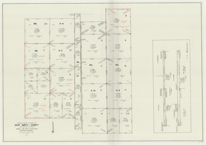
Print $40.00
- Digital $50.00
Deaf Smith County Working Sketch 4
1983
Size 37.0 x 52.4 inches
Map/Doc 68644

Map of Coleman County

Print $20.00
- Digital $50.00
Map of Coleman County
1878
Size 23.9 x 20.3 inches
Map/Doc 3412
Cass County Working Sketch 43

Print $20.00
- Digital $50.00
Cass County Working Sketch 43
1988
Size 25.6 x 29.6 inches
Map/Doc 67946
