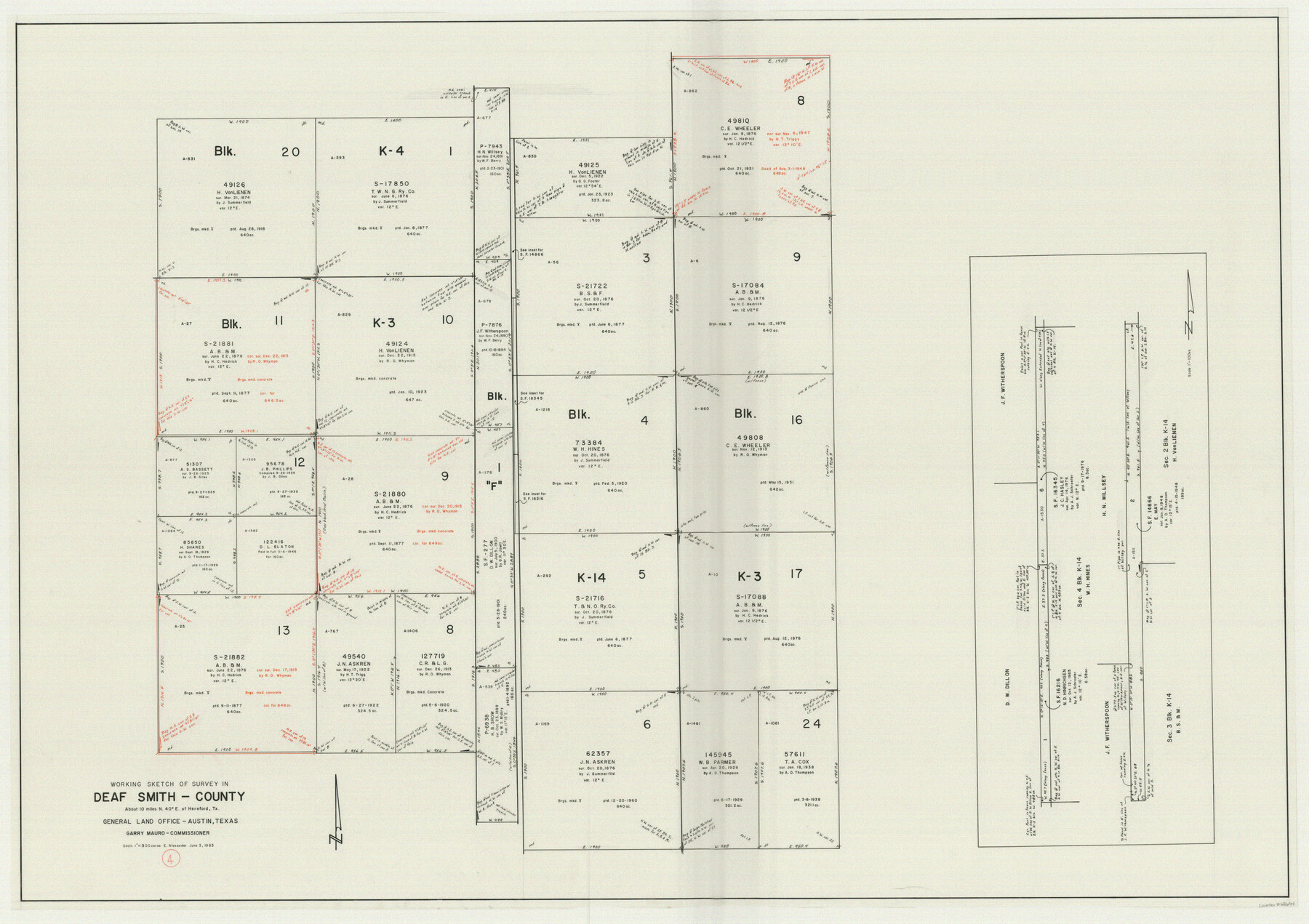
Deaf Smith County Working Sketch 4
-
Map/Doc
68644
-
Collection
General Map Collection
-
Object Dates
6/3/1983 (Creation Date)
-
People and Organizations
Earl Alexander (Draftsman)
-
Counties
Deaf Smith
-
Subjects
Surveying Working Sketch
-
Height x Width
37.0 x 52.4 inches
94.0 x 133.1 cm
-
Scale
1" = 300 varas
Part of: General Map Collection
Navarro County Rolled Sketch 7

Print $20.00
- Digital $50.00
Navarro County Rolled Sketch 7
Size 45.0 x 34.6 inches
Map/Doc 10308
Runnels County Working Sketch 23

Print $20.00
- Digital $50.00
Runnels County Working Sketch 23
1953
Size 34.7 x 31.4 inches
Map/Doc 63619
Orange County Working Sketch 22

Print $20.00
- Digital $50.00
Orange County Working Sketch 22
1939
Size 35.8 x 35.5 inches
Map/Doc 71354
Stonewall County Boundary File 2

Print $12.00
- Digital $50.00
Stonewall County Boundary File 2
Size 14.2 x 8.8 inches
Map/Doc 58955
Val Verde County Working Sketch 3

Print $20.00
- Digital $50.00
Val Verde County Working Sketch 3
Size 17.5 x 24.1 inches
Map/Doc 72138
Brewster County Rolled Sketch 157

Print $20.00
- Digital $50.00
Brewster County Rolled Sketch 157
2008
Size 36.6 x 24.8 inches
Map/Doc 88870
Stieler Map of 1879

Print $4.00
- Digital $50.00
Stieler Map of 1879
1879
Size 28.9 x 23.0 inches
Map/Doc 76057
Van Zandt County Rolled Sketch 3

Print $20.00
- Digital $50.00
Van Zandt County Rolled Sketch 3
1946
Size 23.6 x 36.7 inches
Map/Doc 8145
Schleicher County Sketch File 48

Print $4.00
- Digital $50.00
Schleicher County Sketch File 48
1953
Size 11.2 x 8.7 inches
Map/Doc 36558
Flight Mission No. CLL-1N, Frame 86, Willacy County

Print $20.00
- Digital $50.00
Flight Mission No. CLL-1N, Frame 86, Willacy County
1954
Size 18.4 x 22.1 inches
Map/Doc 87032
Map of Padre Island Showing Location of Zoning Districts

Print $20.00
- Digital $50.00
Map of Padre Island Showing Location of Zoning Districts
1971
Size 18.5 x 26.4 inches
Map/Doc 4812
Flight Mission No. DQN-6K, Frame 89, Calhoun County

Print $20.00
- Digital $50.00
Flight Mission No. DQN-6K, Frame 89, Calhoun County
1953
Size 18.5 x 22.2 inches
Map/Doc 84449
You may also like
Map of the Lands Surveyed by the Memphis, El Paso & Pacific R.R. Company

Print $20.00
- Digital $50.00
Map of the Lands Surveyed by the Memphis, El Paso & Pacific R.R. Company
1859
Size 15.0 x 30.0 inches
Map/Doc 2219
Armstrong County Sketch File A-3

Print $40.00
- Digital $50.00
Armstrong County Sketch File A-3
Size 21.3 x 23.7 inches
Map/Doc 10844
Culberson Co.

Print $40.00
- Digital $50.00
Culberson Co.
1908
Size 49.0 x 32.9 inches
Map/Doc 66796
Flight Mission No. CRC-4R, Frame 75, Chambers County

Print $20.00
- Digital $50.00
Flight Mission No. CRC-4R, Frame 75, Chambers County
1956
Size 18.6 x 22.3 inches
Map/Doc 84879
Refugio County Working Sketch 3

Print $20.00
- Digital $50.00
Refugio County Working Sketch 3
1927
Size 21.9 x 24.6 inches
Map/Doc 63512
Flight Mission No. CRC-5R, Frame 35, Chambers County

Print $20.00
- Digital $50.00
Flight Mission No. CRC-5R, Frame 35, Chambers County
1956
Size 18.5 x 22.3 inches
Map/Doc 84954
[I. M. Bolton, L. S. Thacker, and R. C. Poteet Subdivisions]
![92577, [I. M. Bolton, L. S. Thacker, and R. C. Poteet Subdivisions], Twichell Survey Records](https://historictexasmaps.com/wmedia_w700/maps/92577-1.tif.jpg)
Print $20.00
- Digital $50.00
[I. M. Bolton, L. S. Thacker, and R. C. Poteet Subdivisions]
1924
Size 18.8 x 24.5 inches
Map/Doc 92577
Nolan County Rolled Sketch W

Print $20.00
- Digital $50.00
Nolan County Rolled Sketch W
1902
Size 16.5 x 38.0 inches
Map/Doc 6863
Controlled Mosaic by Jack Amman Photogrammetric Engineers, Inc - Sheet 26

Print $20.00
- Digital $50.00
Controlled Mosaic by Jack Amman Photogrammetric Engineers, Inc - Sheet 26
1954
Size 20.0 x 24.0 inches
Map/Doc 83477
Sutton County Working Sketch 16

Print $40.00
- Digital $50.00
Sutton County Working Sketch 16
1972
Size 30.9 x 67.6 inches
Map/Doc 62359
Newton County Working Sketch 1

Print $20.00
- Digital $50.00
Newton County Working Sketch 1
Size 25.5 x 25.9 inches
Map/Doc 71247
Map of the International and Great Northern Railroad between Austin and San Antonio, Texas

Print $40.00
- Digital $50.00
Map of the International and Great Northern Railroad between Austin and San Antonio, Texas
1881
Size 43.2 x 96.0 inches
Map/Doc 64777