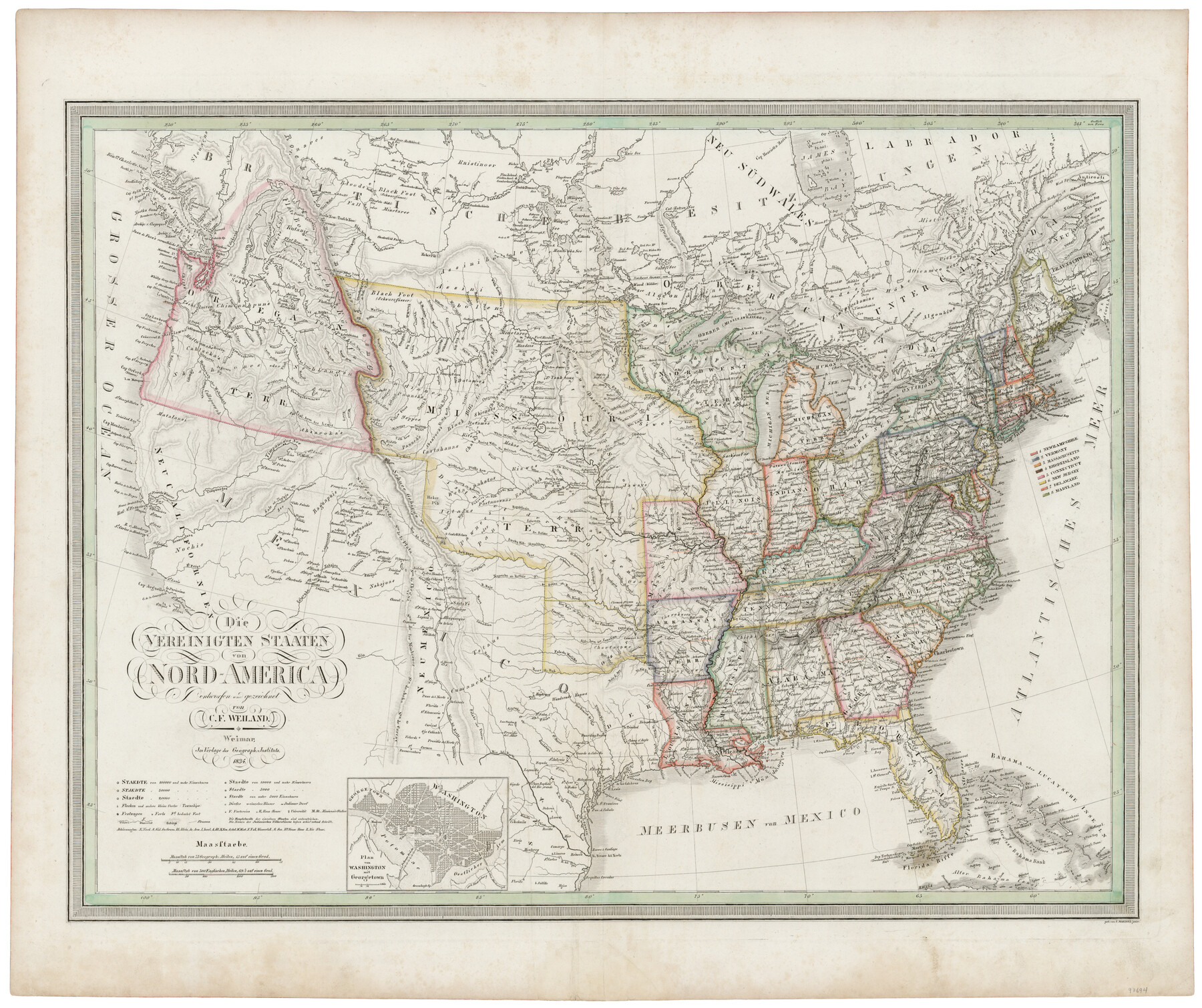
Die Vereinigten Staaten von Nord-America
-
Map/Doc
93694
-
Collection
General Map Collection
-
Object Dates
1834 (Creation Date)
2014/7/8 (File Date)
-
People and Organizations
Carl Ferdinand Weiland (Draftsman)
Carl Ferdinand Weiland (Author)
-
Subjects
United States
-
Height x Width
23.5 x 28.1 inches
59.7 x 71.4 cm
Part of: General Map Collection
Val Verde County Working Sketch 81

Print $20.00
- Digital $50.00
Val Verde County Working Sketch 81
1973
Size 24.6 x 41.7 inches
Map/Doc 72216
[Surveys along the Nueces River, San Patricio District]
![69739, [Surveys along the Nueces River, San Patricio District], General Map Collection](https://historictexasmaps.com/wmedia_w700/maps/69739.tif.jpg)
Print $2.00
- Digital $50.00
[Surveys along the Nueces River, San Patricio District]
1842
Size 11.3 x 7.7 inches
Map/Doc 69739
Uvalde County Working Sketch 10

Print $20.00
- Digital $50.00
Uvalde County Working Sketch 10
1943
Size 30.3 x 38.7 inches
Map/Doc 72080
Flight Mission No. CUG-2P, Frame 27, Kleberg County

Print $20.00
- Digital $50.00
Flight Mission No. CUG-2P, Frame 27, Kleberg County
1956
Size 18.9 x 22.5 inches
Map/Doc 86192
Hays County Rolled Sketch 24

Print $20.00
- Digital $50.00
Hays County Rolled Sketch 24
1924
Size 18.4 x 20.9 inches
Map/Doc 6180
Crane County Sketch File 15 (C-1)

Print $6.00
- Digital $50.00
Crane County Sketch File 15 (C-1)
1925
Size 8.8 x 15.4 inches
Map/Doc 19579
Martin County Sketch File 12

Print $20.00
- Digital $50.00
Martin County Sketch File 12
1937
Size 22.9 x 19.5 inches
Map/Doc 12030
Cottle County Working Sketch 16

Print $20.00
- Digital $50.00
Cottle County Working Sketch 16
1975
Size 24.5 x 21.6 inches
Map/Doc 68326
Starr County Working Sketch 5

Print $20.00
- Digital $50.00
Starr County Working Sketch 5
1930
Size 35.8 x 24.8 inches
Map/Doc 63921
Coryell County Working Sketch 30

Print $20.00
- Digital $50.00
Coryell County Working Sketch 30
2001
Size 37.1 x 38.7 inches
Map/Doc 68237
Bailey County Sketch File B

Print $40.00
- Digital $50.00
Bailey County Sketch File B
Size 14.5 x 20.4 inches
Map/Doc 10891
Presidio County Rolled Sketch 126

Print $20.00
- Digital $50.00
Presidio County Rolled Sketch 126
1986
Size 27.8 x 39.4 inches
Map/Doc 7397
You may also like
Houston, Texas (Looking South)

Print $20.00
Houston, Texas (Looking South)
1891
Size 25.3 x 41.1 inches
Map/Doc 89094
Flight Mission No. BQR-9K, Frame 44, Brazoria County

Print $20.00
- Digital $50.00
Flight Mission No. BQR-9K, Frame 44, Brazoria County
1952
Size 18.7 x 22.3 inches
Map/Doc 84048
Map of the State of Texas Showing Original Land Districts

Print $20.00
- Digital $50.00
Map of the State of Texas Showing Original Land Districts
1891
Size 42.2 x 42.4 inches
Map/Doc 2138
Flight Mission No. BRA-16M, Frame 84, Jefferson County

Print $20.00
- Digital $50.00
Flight Mission No. BRA-16M, Frame 84, Jefferson County
1953
Size 18.6 x 22.1 inches
Map/Doc 85696
Brewster County Rolled Sketch 55

Print $40.00
- Digital $50.00
Brewster County Rolled Sketch 55
1935
Size 24.2 x 58.8 inches
Map/Doc 5227

Flight Mission No. DQO-8K, Frame 41, Galveston County

Print $20.00
- Digital $50.00
Flight Mission No. DQO-8K, Frame 41, Galveston County
1952
Size 18.7 x 22.3 inches
Map/Doc 85148
Archer County Sketch File 6

Print $4.00
- Digital $50.00
Archer County Sketch File 6
Size 7.2 x 8.4 inches
Map/Doc 13634
University Lands, Hudspeth County, Texas, Blocks A to N

Print $40.00
- Digital $50.00
University Lands, Hudspeth County, Texas, Blocks A to N
1935
Size 39.0 x 55.5 inches
Map/Doc 2413
Blanco County

Print $40.00
- Digital $50.00
Blanco County
1916
Size 48.7 x 35.7 inches
Map/Doc 66715
Gregg County Rolled Sketch MHH

Print $203.00
- Digital $50.00
Gregg County Rolled Sketch MHH
1935
Size 10.5 x 15.5 inches
Map/Doc 45668
Flight Mission No. DCL-5C, Frame 70, Kenedy County

Print $20.00
- Digital $50.00
Flight Mission No. DCL-5C, Frame 70, Kenedy County
1943
Size 18.7 x 22.2 inches
Map/Doc 85853