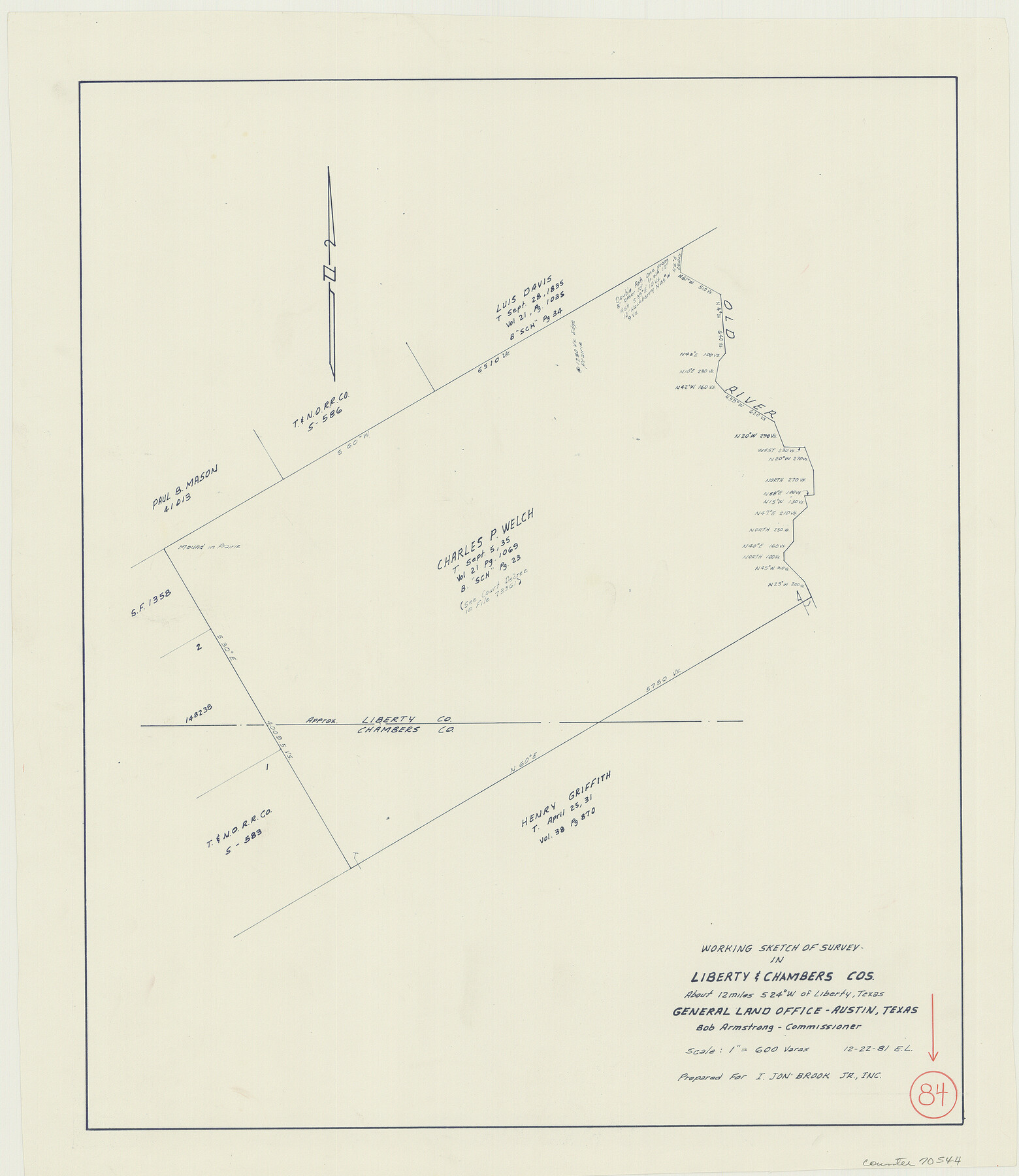
Liberty County Working Sketch 84
- 
                          Map/Doc70544
- 
                            CollectionGeneral Map Collection
- 
                            Object Dates12/22/1981 (Creation Date)
- 
                            People and OrganizationsElisandro Leos (Draftsman)
- 
                            CountiesLiberty Chambers
- 
                            SubjectsSurveying Working Sketch
- 
                            Height x Width21.3 x 18.4 inches54.1 x 46.7 cm
- 
                            Scale1" = 600 varas
Part of: General Map Collection
            Karnes County Sketch File 9


                                            Print $6.00                    
                                             -                         Digital $50.00                                    
                Karnes County Sketch File 9
1876
Size 12.6 x 8.1 inches
                                Map/Doc 28594
            
            Hutchinson County Sketch File 31


                                            Print $20.00                    
                                             -                         Digital $50.00                                    
                Hutchinson County Sketch File 31
Size 19.9 x 15.2 inches
                                Map/Doc 11819
            
            Carte des Côtes du Golfe du Mexique compris entre la Pointe Sud de la Presqu'Ile de la Floride et la Pointe Nord de la Presqu'Ile d'Yucatan


                                            Print $20.00                    
                                             -                         Digital $50.00                                    
                Carte des Côtes du Golfe du Mexique compris entre la Pointe Sud de la Presqu'Ile de la Floride et la Pointe Nord de la Presqu'Ile d'Yucatan
1800
Size 26.0 x 37.5 inches
                                Map/Doc 95322
            
            Township 6 North Range 14 West, North Western District, Louisiana


                                            Print $20.00                    
                                             -                         Digital $50.00                                    
                Township 6 North Range 14 West, North Western District, Louisiana
1841
Size 19.5 x 24.7 inches
                                Map/Doc 65863
            
            Flight Mission No. DQO-2K, Frame 145, Galveston County


                                            Print $20.00                    
                                             -                         Digital $50.00                                    
                Flight Mission No. DQO-2K, Frame 145, Galveston County
1952
Size 18.8 x 22.5 inches
                                Map/Doc 85042
            
            Flight Mission No. CRC-3R, Frame 94, Chambers County


                                            Print $20.00                    
                                             -                         Digital $50.00                                    
                Flight Mission No. CRC-3R, Frame 94, Chambers County
1956
Size 18.5 x 22.3 inches
                                Map/Doc 84832
            
            Roberts County Boundary File 3


                                            Print $44.00                    
                                             -                         Digital $50.00                                    
                Roberts County Boundary File 3
Size 14.2 x 9.3 inches
                                Map/Doc 58368
            
            Travis County Sketch File 78


                                            Print $102.00                    
                                             -                         Digital $50.00                                    
                Travis County Sketch File 78
2010
Size 11.0 x 8.5 inches
                                Map/Doc 90085
            
            Denton County


                                            Print $20.00                    
                                             -                         Digital $50.00                                    
                Denton County
1947
Size 42.5 x 39.7 inches
                                Map/Doc 73130
            
            Edwards County Rolled Sketch ECS


                                            Print $20.00                    
                                             -                         Digital $50.00                                    
                Edwards County Rolled Sketch ECS
1937
Size 24.8 x 38.2 inches
                                Map/Doc 5817
            
            Harbor of Brazos Santiago, Texas


                                            Print $20.00                    
                                             -                         Digital $50.00                                    
                Harbor of Brazos Santiago, Texas
1887
Size 27.3 x 18.3 inches
                                Map/Doc 72992
            
            Zapata County Sketch File 17


                                            Print $32.00                    
                                             -                         Digital $50.00                                    
                Zapata County Sketch File 17
1959
Size 14.4 x 8.9 inches
                                Map/Doc 40960
            You may also like
            Starr County Sketch File 35


                                            Print $24.00                    
                                             -                         Digital $50.00                                    
                Starr County Sketch File 35
1939
Size 14.3 x 8.8 inches
                                Map/Doc 36974
            
            Randall County Working Sketch Graphic Index


                                            Print $20.00                    
                                             -                         Digital $50.00                                    
                Randall County Working Sketch Graphic Index
1958
Size 41.2 x 33.2 inches
                                Map/Doc 76676
            
            [Surveying Sketch of Kendall County School Land, et al in Kerr County, Texas]
            
                                    ![5072, [Surveying Sketch of Kendall County School Land, et al in Kerr County, Texas], Maddox Collection](https://historictexasmaps.com/wmedia_w700/maps/5072-1.tif.jpg) 


    ![5072, [Surveying Sketch of Kendall County School Land, et al in Kerr County, Texas], Maddox Collection](https://historictexasmaps.com/wmedia_w700/maps/5072-1.tif.jpg) 
                                
            
                                            Print $3.00                    
                                             -                         Digital $50.00                                    
                [Surveying Sketch of Kendall County School Land, et al in Kerr County, Texas]
Size 11.9 x 12.9 inches
                                Map/Doc 5072
            
            Limestone County Working Sketch 11


                                            Print $20.00                    
                                             -                         Digital $50.00                                    
                Limestone County Working Sketch 11
1922
Size 36.1 x 33.9 inches
                                Map/Doc 70561
            
            Pecos County Rolled Sketch 81


                                            Print $20.00                    
                                             -                         Digital $50.00                                    
                Pecos County Rolled Sketch 81
1930
Size 35.9 x 25.4 inches
                                Map/Doc 7240
            
            Dimmit County Sketch File 42


                                            Print $2.00                    
                                             -                         Digital $50.00                                    
                Dimmit County Sketch File 42
1901
Size 6.2 x 3.9 inches
                                Map/Doc 21171
            
            Bell County Sketch File 26


                                            Print $14.00                    
                                             -                         Digital $50.00                                    
                Bell County Sketch File 26
1886
Size 14.2 x 8.8 inches
                                Map/Doc 14426
            
            Sketch No. 2 [showing Block 46, Block M21, Block B4 and Block Y south of Canadian River]
            
                                    ![89929, Sketch No. 2 [showing Block 46, Block M21, Block B4 and Block Y south of Canadian River], Twichell Survey Records](https://historictexasmaps.com/wmedia_w700/maps/89929-1.tif.jpg) 


    ![89929, Sketch No. 2 [showing Block 46, Block M21, Block B4 and Block Y south of Canadian River], Twichell Survey Records](https://historictexasmaps.com/wmedia_w700/maps/89929-1.tif.jpg) 
                                
            
                                            Print $20.00                    
                                             -                         Digital $50.00                                    
                Sketch No. 2 [showing Block 46, Block M21, Block B4 and Block Y south of Canadian River]
1927
Size 36.8 x 43.7 inches
                                Map/Doc 89929
            
            [Beaumont, Sour Lake and Western Ry. Right of Way and Alignment - Frisco]
            
                                    ![64116, [Beaumont, Sour Lake and Western Ry. Right of Way and Alignment - Frisco], General Map Collection](https://historictexasmaps.com/wmedia_w700/maps/64116.tif.jpg) 


    ![64116, [Beaumont, Sour Lake and Western Ry. Right of Way and Alignment - Frisco], General Map Collection](https://historictexasmaps.com/wmedia_w700/maps/64116.tif.jpg) 
                                
            
                                            Print $20.00                    
                                             -                         Digital $50.00                                    
                [Beaumont, Sour Lake and Western Ry. Right of Way and Alignment - Frisco]
1910
Size 20.3 x 46.1 inches
                                Map/Doc 64116
            
            Flight Mission No. BRA-7M, Frame 134, Jefferson County


                                            Print $20.00                    
                                             -                         Digital $50.00                                    
                Flight Mission No. BRA-7M, Frame 134, Jefferson County
1953
Size 18.6 x 22.5 inches
                                Map/Doc 85528
            
            Henderson County Rolled Sketch 1


                                            Print $20.00                    
                                             -                         Digital $50.00                                    
                Henderson County Rolled Sketch 1
1942
Size 34.0 x 38.3 inches
                                Map/Doc 9159
            
            [Right of Way & Track Map, The Texas & Pacific Ry. Co. Main Line]
            
                                    ![64678, [Right of Way & Track Map, The Texas & Pacific Ry. Co. Main Line], General Map Collection](https://historictexasmaps.com/wmedia_w700/maps/64678.tif.jpg) 


    ![64678, [Right of Way & Track Map, The Texas & Pacific Ry. Co. Main Line], General Map Collection](https://historictexasmaps.com/wmedia_w700/maps/64678.tif.jpg) 
                                
            
                                            Print $20.00                    
                                             -                         Digital $50.00                                    
                [Right of Way & Track Map, The Texas & Pacific Ry. Co. Main Line]
Size 11.1 x 18.3 inches
                                Map/Doc 64678
            