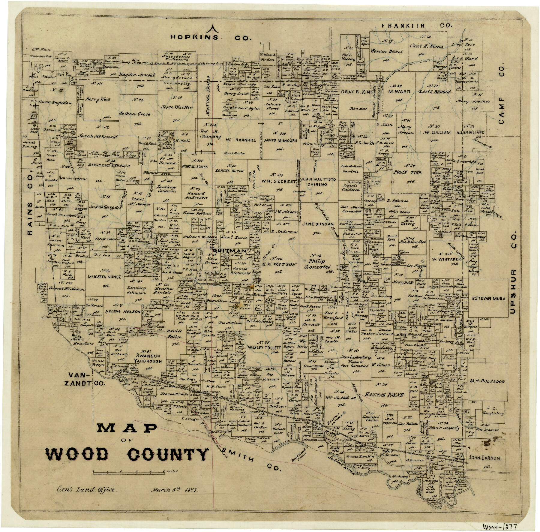
Map of Wood County
- 
                          Map/Doc
4168
 - 
                            Collection
General Map Collection
 - 
                            Object Dates
3/5/1877 (Creation Date)
 - 
                            Counties
Wood
 - 
                            Subjects
County
 - 
                            Height x Width
16.8 x 17.1 inches
42.7 x 43.4 cm
 - 
                            Features
Quitman
Little Cypress Creek
Sabine River
H&GN
T&P
Little Creek
Sandy Creek
Holly Creek
Glade Creek
Fork of Cypress [Creek]
Little Caney Creek
Big Sandy Creek
Caney Creek
Dillards Creek
Indian Creek
Dry Creek
Lake Fork [Creek]
 
Part of: General Map Collection
            El Paso County Rolled Sketch 45


                                            Print $20.00                    
                                             -                         Digital $50.00                                    
                El Paso County Rolled Sketch 45
Size 21.0 x 24.3 inches
                                Map/Doc 5831
            
            Starr County Sketch File 42


                                            Print $20.00                    
                                             -                         Digital $50.00                                    
                Starr County Sketch File 42
1941
Size 19.0 x 21.6 inches
                                Map/Doc 12341
            
            Right of Way and Track Map, the Missouri, Kansas & Texas Ry. Of Texas operated by the Missouri, Kansas & Texas Ry. Of  Texas, Houston Division


                                            Print $40.00                    
                                             -                         Digital $50.00                                    
                Right of Way and Track Map, the Missouri, Kansas & Texas Ry. Of Texas operated by the Missouri, Kansas & Texas Ry. Of Texas, Houston Division
1918
Size 25.6 x 62.5 inches
                                Map/Doc 64786
            
            Upton County Rolled Sketch 56


                                            Print $158.00                    
                                             -                         Digital $50.00                                    
                Upton County Rolled Sketch 56
1934
Size 10.0 x 15.1 inches
                                Map/Doc 49413
            
            Jefferson County Rolled Sketch 60


                                            Print $20.00                    
                                             -                         Digital $50.00                                    
                Jefferson County Rolled Sketch 60
1885
Size 34.0 x 35.9 inches
                                Map/Doc 9316
            
            [Texas Gulf Coast]


                                            Print $20.00                    
                                             -                         Digital $50.00                                    
                [Texas Gulf Coast]
Size 27.3 x 18.2 inches
                                Map/Doc 72677
            
            Trinity River, Post Oak Creek Sheet


                                            Print $4.00                    
                                             -                         Digital $50.00                                    
                Trinity River, Post Oak Creek Sheet
1930
Size 20.6 x 23.0 inches
                                Map/Doc 65227
            
            Liberty County Working Sketch 36


                                            Print $20.00                    
                                             -                         Digital $50.00                                    
                Liberty County Working Sketch 36
1948
Size 24.3 x 25.0 inches
                                Map/Doc 70495
            
            Right of Way and Track Map, The Missouri, Kansas and Texas Ry. of Texas operated by the Missouri, Kansas and Texas Ry. of Texas, Henrietta Division


                                            Print $40.00                    
                                             -                         Digital $50.00                                    
                Right of Way and Track Map, The Missouri, Kansas and Texas Ry. of Texas operated by the Missouri, Kansas and Texas Ry. of Texas, Henrietta Division
1918
Size 24.8 x 56.3 inches
                                Map/Doc 64069
            
            Randall County Working Sketch 1


                                            Print $20.00                    
                                             -                         Digital $50.00                                    
                Randall County Working Sketch 1
1974
Size 28.0 x 31.6 inches
                                Map/Doc 71838
            
            Map of Ramsey State Farm, Brazoria County, Texas


                                            Print $20.00                    
                                             -                         Digital $50.00                                    
                Map of Ramsey State Farm, Brazoria County, Texas
Size 28.7 x 36.5 inches
                                Map/Doc 62998
            
            Tyler County Sketch File 1


                                            Print $22.00                    
                                             -                         Digital $50.00                                    
                Tyler County Sketch File 1
1849
Size 12.2 x 15.3 inches
                                Map/Doc 38607
            You may also like
            Parker County Boundary File 68


                                            Print $12.00                    
                                             -                         Digital $50.00                                    
                Parker County Boundary File 68
Size 8.1 x 3.6 inches
                                Map/Doc 57848
            
            Travis County Sketch File 5


                                            Print $4.00                    
                                             -                         Digital $50.00                                    
                Travis County Sketch File 5
Size 11.0 x 8.2 inches
                                Map/Doc 38281
            
            Denton County Working Sketch 12


                                            Print $20.00                    
                                             -                         Digital $50.00                                    
                Denton County Working Sketch 12
1960
Size 29.8 x 17.3 inches
                                Map/Doc 68617
            
            Flight Mission No. DAH-17M, Frame 68, Orange County


                                            Print $20.00                    
                                             -                         Digital $50.00                                    
                Flight Mission No. DAH-17M, Frame 68, Orange County
1953
Size 18.6 x 22.4 inches
                                Map/Doc 86902
            
            Austin County Sketch File 10


                                            Print $40.00                    
                                             -                         Digital $50.00                                    
                Austin County Sketch File 10
1895
Size 25.5 x 21.0 inches
                                Map/Doc 10875
            
            [Surveys in the Liberty District in Tyler and Polk Counties]


                                            Print $2.00                    
                                             -                         Digital $50.00                                    
                [Surveys in the Liberty District in Tyler and Polk Counties]
1847
Size 5.9 x 8.4 inches
                                Map/Doc 331
            
            Galveston County NRC Article 33.136 Sketch 78


                                            Print $24.00                    
                                             -                         Digital $50.00                                    
                Galveston County NRC Article 33.136 Sketch 78
2015
Size 36.0 x 24.0 inches
                                Map/Doc 95129
            
            Map of Rotan Fisher County, Texas


                                            Print $20.00                    
                                             -                         Digital $50.00                                    
                Map of Rotan Fisher County, Texas
1926
Size 32.2 x 36.5 inches
                                Map/Doc 93231
            
            Cottle County, Texas


                                            Print $20.00                    
                                             -                         Digital $50.00                                    
                Cottle County, Texas
1891
Size 23.1 x 17.0 inches
                                Map/Doc 619
            
            Houston Ship Channel, Atkinson Island to Alexander Island


                                            Print $40.00                    
                                             -                         Digital $50.00                                    
                Houston Ship Channel, Atkinson Island to Alexander Island
1973
Size 36.7 x 50.2 inches
                                Map/Doc 69902
            
            Wood County Sketch File 14


                                            Print $46.00                    
                                             -                         Digital $50.00                                    
                Wood County Sketch File 14
1907
Size 14.3 x 8.7 inches
                                Map/Doc 40671