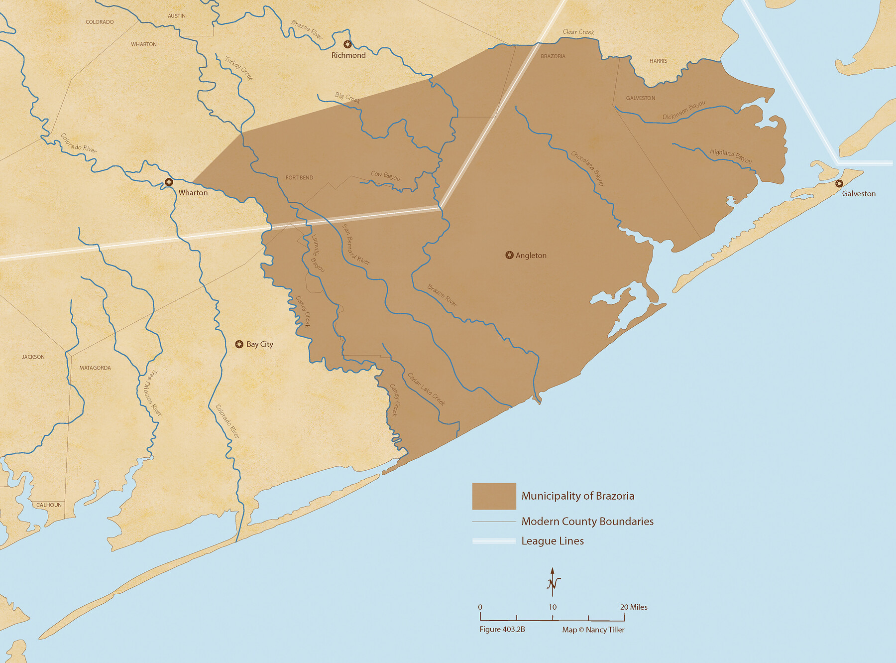
The Mexican Municipality of Brazoria. March 6, 1834
Figure No. 403.2 from 'A Boundary Atlas of Texas, 1821-1845' by Jim Tiller
-
Map/Doc
96016
-
Collection
Nancy and Jim Tiller Digital Collection
-
Object Dates
2020/1/1 (Creation Date)
-
People and Organizations
Jim Tiller (Author)
Nancy Tiller (Cartographer)
Gang Gong (GIS Professional)
-
Subjects
Atlas Mexican Texas Texas Boundaries
-
Height x Width
16.0 x 21.7 inches
40.6 x 55.1 cm
-
Medium
digital image
-
Comments
To purchase a digital PDF copy of "A Boundary Atlas of Texas, 1821-1845" see 96437.
Part of: Nancy and Jim Tiller Digital Collection
The Republic County of Milam. December 31, 1838

Print $20.00
The Republic County of Milam. December 31, 1838
2020
Size 17.4 x 21.6 inches
Map/Doc 96227
The Judicial District/County of Burnet. Boundaries Redefined, December 6, 1841

Print $20.00
The Judicial District/County of Burnet. Boundaries Redefined, December 6, 1841
2020
Size 19.2 x 21.6 inches
Map/Doc 96323
The Republic County of Jasper. December 29, 1845

Print $20.00
The Republic County of Jasper. December 29, 1845
2020
Size 19.5 x 21.7 inches
Map/Doc 96196
From Citizens of Nacogdoches County for the Creation of a New Judicial County (Unnamed), November 16, 1840

Print $20.00
From Citizens of Nacogdoches County for the Creation of a New Judicial County (Unnamed), November 16, 1840
2020
Size 14.6 x 21.7 inches
Map/Doc 96409
The Republic County of Fannin. November 28. 1839

Print $20.00
The Republic County of Fannin. November 28. 1839
2020
Size 12.9 x 21.7 inches
Map/Doc 96129
The Republic County of Harrison. January 8, 1844

Print $20.00
The Republic County of Harrison. January 8, 1844
2020
Size 18.6 x 21.7 inches
Map/Doc 96175
The Republic County of Washington. January 29, 1842

Print $20.00
The Republic County of Washington. January 29, 1842
2020
Size 11.8 x 21.7 inches
Map/Doc 96307
The Republic County of Matagorda. December 24, 1844

Print $20.00
The Republic County of Matagorda. December 24, 1844
2020
Size 21.0 x 21.7 inches
Map/Doc 96223
The Republic County of Gonzales. Spring 1842

Print $20.00
The Republic County of Gonzales. Spring 1842
2020
Size 14.7 x 21.7 inches
Map/Doc 96159
The Mexican Department of Nacogdoches. On the Eve of Texas Independence, 1836

Print $20.00
The Mexican Department of Nacogdoches. On the Eve of Texas Independence, 1836
2020
Size 18.4 x 21.7 inches
Map/Doc 95974
From Citizens of Brazoria County to Annex the Island of San Luis, December 12, 1839

Print $20.00
From Citizens of Brazoria County to Annex the Island of San Luis, December 12, 1839
2020
Size 13.8 x 21.7 inches
Map/Doc 96387
The Republic County of Victoria. January 29, 1842

Print $20.00
The Republic County of Victoria. January 29, 1842
2020
Size 24.3 x 21.7 inches
Map/Doc 96298
You may also like
Flight Mission No. DQO-2K, Frame 102, Galveston County

Print $20.00
- Digital $50.00
Flight Mission No. DQO-2K, Frame 102, Galveston County
1952
Size 18.8 x 22.5 inches
Map/Doc 85029
Garza County Rolled Sketch 6D

Print $20.00
- Digital $50.00
Garza County Rolled Sketch 6D
1913
Size 17.4 x 16.0 inches
Map/Doc 5998
Padre Island National Seashore

Print $20.00
- Digital $50.00
Padre Island National Seashore
Size 16.0 x 21.7 inches
Map/Doc 60537

[Plat of Boundary Line between Comal and Hays Counties]
![65328, [Plat of Boundary Line between Comal and Hays Counties], General Map Collection](https://historictexasmaps.com/wmedia_w700/pdf_converted_jpg/qi_pdf_thumbnail_19768.jpg)
Print $20.00
- Digital $50.00
[Plat of Boundary Line between Comal and Hays Counties]
1947
Size 11.4 x 17.7 inches
Map/Doc 65328
Gulf Oil Corp. Fishgide - Freeport

Gulf Oil Corp. Fishgide - Freeport
1960
Size 12.3 x 22.4 inches
Map/Doc 75978
Layout of the porciones as described in the Visita General of Camargo, 1767

Layout of the porciones as described in the Visita General of Camargo, 1767
2009
Size 11.0 x 8.5 inches
Map/Doc 94041
R. L. Gladney 160 acres in northwest 48, Block 9

Print $20.00
- Digital $50.00
R. L. Gladney 160 acres in northwest 48, Block 9
Size 15.9 x 30.8 inches
Map/Doc 91731
Flight Mission No. DAG-21K, Frame 34, Matagorda County

Print $20.00
- Digital $50.00
Flight Mission No. DAG-21K, Frame 34, Matagorda County
1952
Size 18.7 x 22.3 inches
Map/Doc 86401
Franklin County Working Sketch 2

Print $20.00
- Digital $50.00
Franklin County Working Sketch 2
1953
Size 33.3 x 29.9 inches
Map/Doc 69240
Johnson County

Print $20.00
- Digital $50.00
Johnson County
1943
Size 43.3 x 40.2 inches
Map/Doc 95549
Terrell County Sketch File 2-3

Print $38.00
- Digital $50.00
Terrell County Sketch File 2-3
1882
Size 9.1 x 7.7 inches
Map/Doc 37879