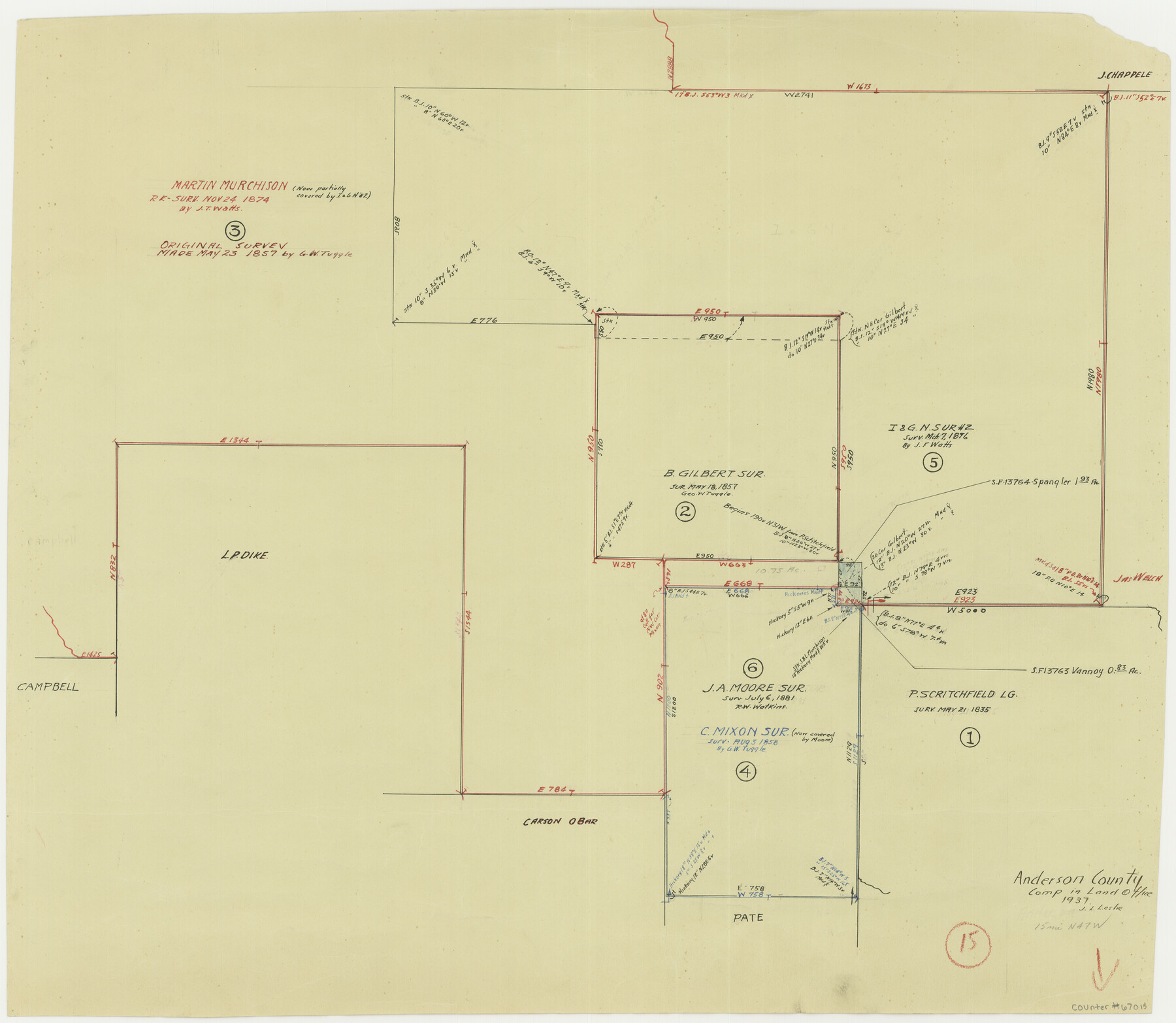
Anderson County Working Sketch 15
-
Map/Doc
67015
-
Collection
General Map Collection
-
Object Dates
1937 (Creation Date)
-
People and Organizations
John L. Leslie (Draftsman)
-
Counties
Anderson
-
Subjects
Surveying Working Sketch
-
Height x Width
19.7 x 22.7 inches
50.0 x 57.7 cm
-
Comments
Surveys located about 15 miles North 47 degrees West of Palestine, Texas.
Part of: General Map Collection
Glasscock County

Print $20.00
- Digital $50.00
Glasscock County
1933
Size 47.0 x 39.2 inches
Map/Doc 1839
Nueces River, Corpus Christi Sheet No. 4

Print $20.00
- Digital $50.00
Nueces River, Corpus Christi Sheet No. 4
1938
Size 31.6 x 41.8 inches
Map/Doc 65093
Refugio County Sketch File 8a

Print $2.00
- Digital $50.00
Refugio County Sketch File 8a
Size 8.1 x 10.2 inches
Map/Doc 35253
Pecos County Sketch File 20

Print $20.00
- Digital $50.00
Pecos County Sketch File 20
Size 25.9 x 12.0 inches
Map/Doc 12160
Flight Mission No. BQY-4M, Frame 125, Harris County

Print $20.00
- Digital $50.00
Flight Mission No. BQY-4M, Frame 125, Harris County
1953
Size 18.6 x 22.5 inches
Map/Doc 85293
Pecos County Working Sketch 133

Print $20.00
- Digital $50.00
Pecos County Working Sketch 133
1979
Size 44.0 x 37.2 inches
Map/Doc 71607
Hays County Sketch File 35

Print $4.00
- Digital $50.00
Hays County Sketch File 35
1873
Size 12.8 x 8.2 inches
Map/Doc 26277
Reagan County Boundary File 1c

Print $56.00
- Digital $50.00
Reagan County Boundary File 1c
Size 9.2 x 8.2 inches
Map/Doc 58171
Maverick County Rolled Sketch 17

Print $20.00
- Digital $50.00
Maverick County Rolled Sketch 17
1910
Size 20.2 x 31.7 inches
Map/Doc 6710
Colorado County Sketch File 20

Print $6.00
- Digital $50.00
Colorado County Sketch File 20
Size 6.0 x 7.6 inches
Map/Doc 18954
Coleman County Sketch File 2

Print $2.00
- Digital $50.00
Coleman County Sketch File 2
Size 8.4 x 3.3 inches
Map/Doc 18669
Uvalde County Sketch File 6

Print $20.00
- Digital $50.00
Uvalde County Sketch File 6
Size 25.0 x 31.4 inches
Map/Doc 12526
You may also like
Map of Kinney County

Print $20.00
- Digital $50.00
Map of Kinney County
1863
Size 31.4 x 29.7 inches
Map/Doc 3774
[Blocks B-19, B-29, 34 and 5]
![91846, [Blocks B-19, B-29, 34 and 5], Twichell Survey Records](https://historictexasmaps.com/wmedia_w700/maps/91846-1.tif.jpg)
Print $20.00
- Digital $50.00
[Blocks B-19, B-29, 34 and 5]
1902
Size 12.2 x 16.4 inches
Map/Doc 91846
Jeff Davis County Working Sketch 28

Print $20.00
- Digital $50.00
Jeff Davis County Working Sketch 28
1967
Size 21.2 x 28.6 inches
Map/Doc 66523

[Sketch of Leagues 458, 459, 474, 475, 480 and 481]
![91547, [Sketch of Leagues 458, 459, 474, 475, 480 and 481], Twichell Survey Records](https://historictexasmaps.com/wmedia_w700/maps/91547-1.tif.jpg)
Print $2.00
- Digital $50.00
[Sketch of Leagues 458, 459, 474, 475, 480 and 481]
Size 5.2 x 8.3 inches
Map/Doc 91547
Laguna Madre, Register No. 1476A

Print $40.00
- Digital $50.00
Laguna Madre, Register No. 1476A
1880
Size 31.3 x 53.3 inches
Map/Doc 73604
Padre Island National Seashore, Texas - Dependent Resurvey

Print $4.00
- Digital $50.00
Padre Island National Seashore, Texas - Dependent Resurvey
2001
Size 18.4 x 24.1 inches
Map/Doc 60553
Montgomery County Working Sketch 31

Print $20.00
- Digital $50.00
Montgomery County Working Sketch 31
Size 24.7 x 18.7 inches
Map/Doc 71138
[Location St. L. & S. W. R. R. Through Cherokee County]
![64044, [Location St. L. & S. W. R. R. Through Cherokee County], General Map Collection](https://historictexasmaps.com/wmedia_w700/maps/64044-1.tif.jpg)
Print $40.00
- Digital $50.00
[Location St. L. & S. W. R. R. Through Cherokee County]
Size 39.2 x 122.1 inches
Map/Doc 64044
[I. Killough and Hiram Cates surveys and vicinity]
![91851, [I. Killough and Hiram Cates surveys and vicinity], Twichell Survey Records](https://historictexasmaps.com/wmedia_w700/maps/91851-1.tif.jpg)
Print $20.00
- Digital $50.00
[I. Killough and Hiram Cates surveys and vicinity]
Size 27.5 x 9.2 inches
Map/Doc 91851
Ochiltree County Sketch File 2

Print $38.00
- Digital $50.00
Ochiltree County Sketch File 2
1903
Size 11.3 x 8.6 inches
Map/Doc 33168
Flight Mission No. CRK-5P, Frame 126, Refugio County

Print $20.00
- Digital $50.00
Flight Mission No. CRK-5P, Frame 126, Refugio County
1956
Size 18.7 x 22.4 inches
Map/Doc 86929