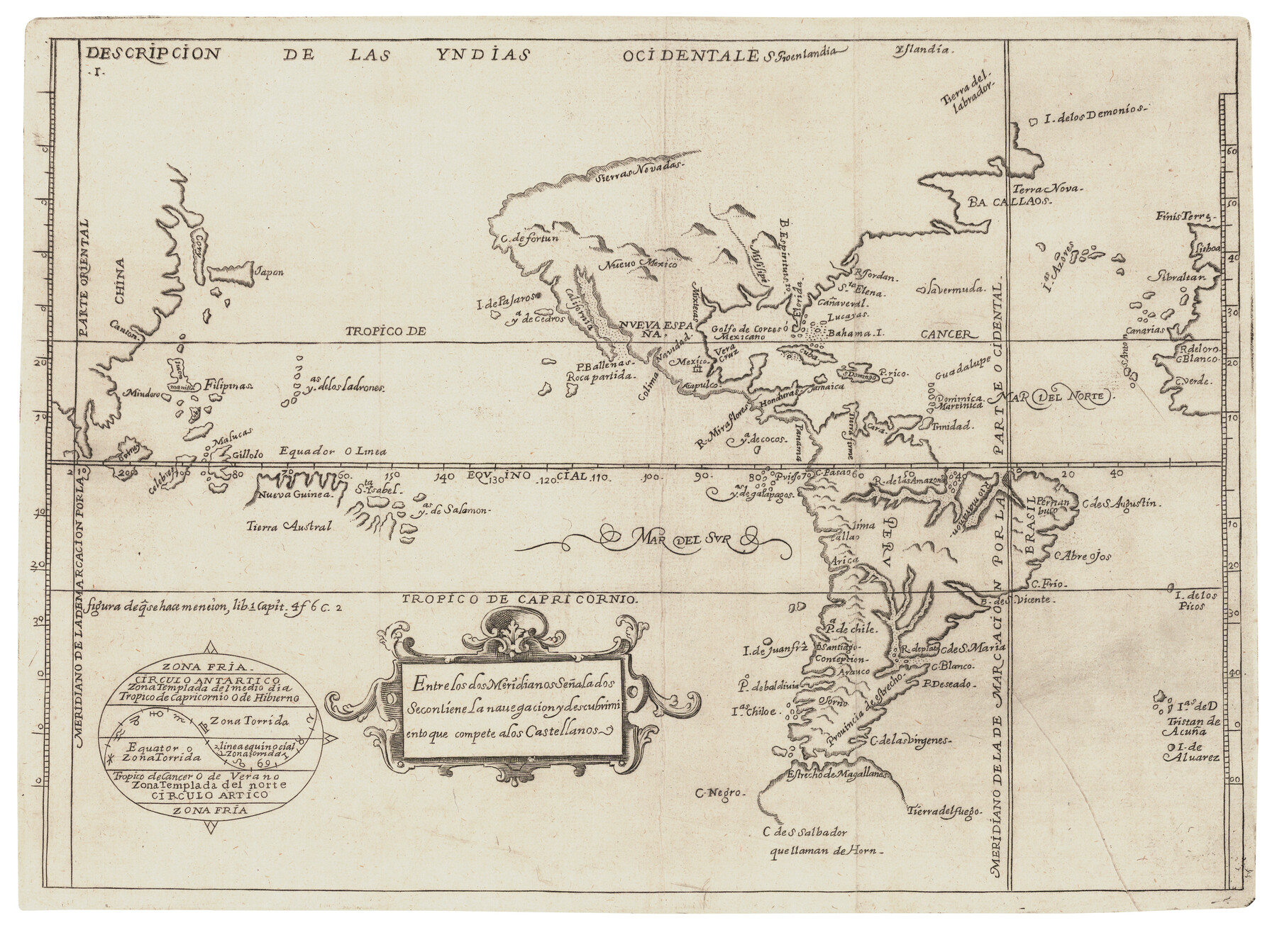
Descripcion de las Yndias Ocidentales
-
Map/Doc
95962
-
Collection
General Map Collection
-
Object Dates
1726 (Edition Date)
-
People and Organizations
[Antonio de Herrera y Tordesillas] (Cartographer)
-
Subjects
North America South America
-
Height x Width
9.6 x 13.2 inches
24.4 x 33.5 cm
-
Medium
paper, etching/engraving/lithograph
-
Comments
This map was first published in "Historia general" in 1601.
Part of: General Map Collection
Flight Mission No. DQO-2K, Frame 97, Galveston County

Print $20.00
- Digital $50.00
Flight Mission No. DQO-2K, Frame 97, Galveston County
1952
Size 18.7 x 22.5 inches
Map/Doc 85024
Map of Hopkins Co.

Print $20.00
- Digital $50.00
Map of Hopkins Co.
1885
Size 34.0 x 33.9 inches
Map/Doc 16854
Palo Pinto County Working Sketch 25

Print $20.00
- Digital $50.00
Palo Pinto County Working Sketch 25
1991
Map/Doc 71408
Hamilton County Sketch File 1

Print $4.00
- Digital $50.00
Hamilton County Sketch File 1
Size 12.5 x 8.2 inches
Map/Doc 24897
Denton County Working Sketch 25

Print $20.00
- Digital $50.00
Denton County Working Sketch 25
1990
Size 13.7 x 18.0 inches
Map/Doc 68630
Marion County Working Sketch 6

Print $20.00
- Digital $50.00
Marion County Working Sketch 6
1962
Size 33.7 x 19.8 inches
Map/Doc 70781
Flight Mission No. BRA-8M, Frame 27, Jefferson County

Print $20.00
- Digital $50.00
Flight Mission No. BRA-8M, Frame 27, Jefferson County
1953
Size 18.6 x 22.3 inches
Map/Doc 85582
Angelina County Sketch File 16

Print $11.00
- Digital $50.00
Angelina County Sketch File 16
Size 7.9 x 3.8 inches
Map/Doc 13004
Flight Mission No. BRA-17M, Frame 14, Jefferson County

Print $20.00
- Digital $50.00
Flight Mission No. BRA-17M, Frame 14, Jefferson County
1953
Size 18.5 x 22.3 inches
Map/Doc 85795
Ochiltree County Boundary File 2

Print $4.00
- Digital $50.00
Ochiltree County Boundary File 2
Size 7.7 x 8.6 inches
Map/Doc 57675
Milam County Rolled Sketch 3A

Print $40.00
- Digital $50.00
Milam County Rolled Sketch 3A
1967
Size 49.5 x 43.3 inches
Map/Doc 9522
Harrison County Rolled Sketch 11

Print $20.00
- Digital $50.00
Harrison County Rolled Sketch 11
1957
Size 24.7 x 30.2 inches
Map/Doc 6154
You may also like
San Jacinto County Working Sketch 11

Print $20.00
- Digital $50.00
San Jacinto County Working Sketch 11
1935
Size 40.1 x 40.0 inches
Map/Doc 63724
Callahan County Boundary File 1a

Print $4.00
- Digital $50.00
Callahan County Boundary File 1a
Size 13.3 x 8.7 inches
Map/Doc 51085
Cherokee County Sketch File 3

Print $4.00
- Digital $50.00
Cherokee County Sketch File 3
1849
Size 7.5 x 11.0 inches
Map/Doc 18115
Map of Wood County Showing Location of the Texas and Pacific Railway

Print $20.00
- Digital $50.00
Map of Wood County Showing Location of the Texas and Pacific Railway
1872
Size 19.1 x 23.8 inches
Map/Doc 64135
Shelby County Sketch File 2

Print $4.00
- Digital $50.00
Shelby County Sketch File 2
1849
Size 12.6 x 7.6 inches
Map/Doc 36593
Brazoria County Working Sketch 2

Print $20.00
- Digital $50.00
Brazoria County Working Sketch 2
1907
Size 20.9 x 20.8 inches
Map/Doc 67487
Wood County Sketch File 13

Print $24.00
- Digital $50.00
Wood County Sketch File 13
1866
Size 12.5 x 7.6 inches
Map/Doc 40668
Real County Working Sketch 33

Print $40.00
- Digital $50.00
Real County Working Sketch 33
1948
Size 61.0 x 37.7 inches
Map/Doc 71925
[H. & G. N. RR. Co. Block 1]
![90890, [H. & G. N. RR. Co. Block 1], Twichell Survey Records](https://historictexasmaps.com/wmedia_w700/maps/90890-1.tif.jpg)
Print $20.00
- Digital $50.00
[H. & G. N. RR. Co. Block 1]
Size 17.1 x 28.0 inches
Map/Doc 90890
[Surveys in Bexar County]
![93, [Surveys in Bexar County], General Map Collection](https://historictexasmaps.com/wmedia_w700/maps/93.tif.jpg)
Print $2.00
- Digital $50.00
[Surveys in Bexar County]
Size 11.3 x 6.9 inches
Map/Doc 93
Hockley County Rolled Sketch 6

Print $40.00
- Digital $50.00
Hockley County Rolled Sketch 6
Size 30.6 x 48.2 inches
Map/Doc 6216
