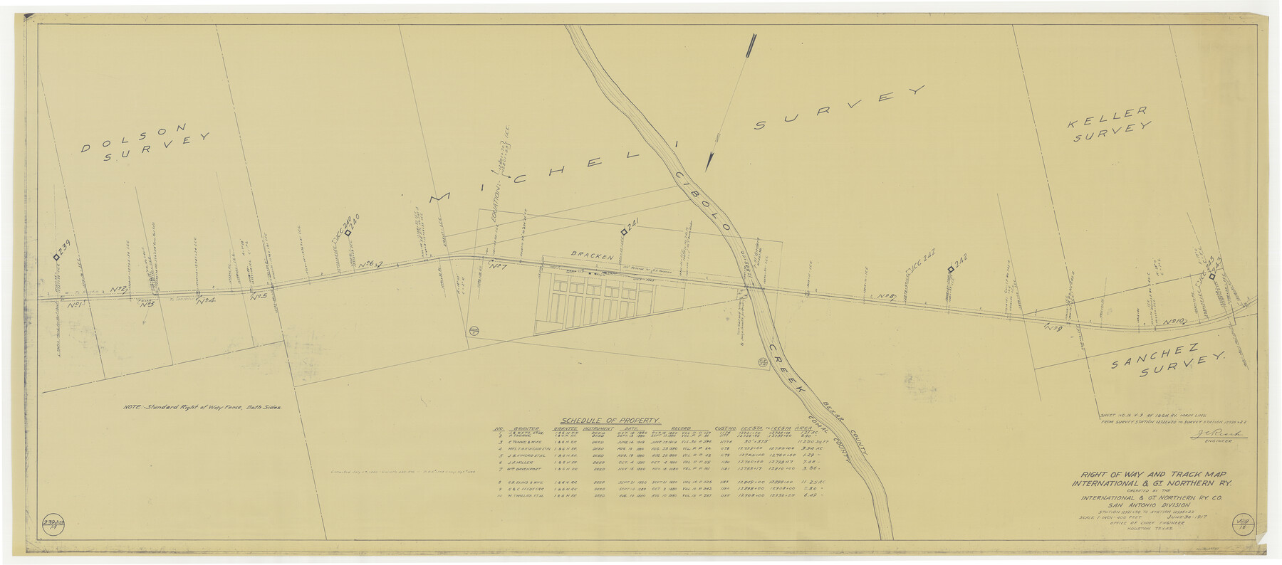
Right of Way and Track Map International & Gt Northern Ry. operated by the International & Gt. Northern Ry. Co., San Antonio Division
Station 12721+70 to Station 12935+22
Z-2-181
-
Map/Doc
64789
-
Collection
General Map Collection
-
Object Dates
1923/7/10 (Revision Date)
1917/6/30 (Creation Date)
-
People and Organizations
J. C. Resch (Surveyor/Engineer)
-
Counties
Comal Bexar
-
Subjects
Railroads
-
Height x Width
25.5 x 57.8 inches
64.8 x 146.8 cm
-
Medium
blueprint/diazo
-
Scale
1" = 400 feet
-
Comments
See counter nos. 64586 through 64589, 64787, and 64788 for other sheets of the map.
-
Features
I&GN
Cibolo Creek
Bracken
[Railroad line] to Austin
[Railroad line] to San Antonio
Part of: General Map Collection
Travis County Appraisal District Plat Map 2_0803

Print $20.00
- Digital $50.00
Travis County Appraisal District Plat Map 2_0803
Size 21.5 x 26.4 inches
Map/Doc 94239
[William Steele Survey near Copano Bay]
![60284, [William Steele Survey near Copano Bay], General Map Collection](https://historictexasmaps.com/wmedia_w700/maps/60284-1.tif.jpg)
Print $3.00
- Digital $50.00
[William Steele Survey near Copano Bay]
1927
Size 15.5 x 9.5 inches
Map/Doc 60284
Map of Unsurveyed Bed of Spring Creek

Print $40.00
- Digital $50.00
Map of Unsurveyed Bed of Spring Creek
1920
Size 78.7 x 27.1 inches
Map/Doc 65695
Culberson County Rolled Sketch 45

Print $20.00
- Digital $50.00
Culberson County Rolled Sketch 45
1954
Size 19.1 x 23.4 inches
Map/Doc 5667
Goliad County Sketch File 12

Print $18.00
- Digital $50.00
Goliad County Sketch File 12
1857
Size 12.9 x 7.9 inches
Map/Doc 24230
Taylor County Working Sketch 5

Print $20.00
- Digital $50.00
Taylor County Working Sketch 5
1950
Size 31.1 x 24.7 inches
Map/Doc 69615
Jones County Boundary File 2

Print $6.00
- Digital $50.00
Jones County Boundary File 2
Size 12.4 x 8.3 inches
Map/Doc 55676
Crane County Working Sketch 33

Print $20.00
- Digital $50.00
Crane County Working Sketch 33
1985
Size 30.3 x 27.6 inches
Map/Doc 68310
Parker County Sketch File A

Print $4.00
- Digital $50.00
Parker County Sketch File A
1857
Size 7.9 x 8.2 inches
Map/Doc 33507
Sabine County Sketch File 2

Print $4.00
Sabine County Sketch File 2
Size 10.0 x 7.9 inches
Map/Doc 35602
Wheeler County Working Sketch 16

Print $20.00
- Digital $50.00
Wheeler County Working Sketch 16
1982
Size 38.9 x 25.8 inches
Map/Doc 72505
Brazos River, Sandpit Extension Sheet

Print $20.00
- Digital $50.00
Brazos River, Sandpit Extension Sheet
1926
Size 31.3 x 36.5 inches
Map/Doc 69663
You may also like
Flight Mission No. BRE-1P, Frame 28, Nueces County

Print $20.00
- Digital $50.00
Flight Mission No. BRE-1P, Frame 28, Nueces County
1956
Size 16.6 x 16.1 inches
Map/Doc 86624
Flight Mission No. DQO-7K, Frame 110, Galveston County

Print $20.00
- Digital $50.00
Flight Mission No. DQO-7K, Frame 110, Galveston County
1952
Size 18.7 x 22.3 inches
Map/Doc 85125
Brewster County Working Sketch 50

Print $40.00
- Digital $50.00
Brewster County Working Sketch 50
1950
Size 31.5 x 48.4 inches
Map/Doc 67584
Foard County Sketch File 15

Print $8.00
- Digital $50.00
Foard County Sketch File 15
1883
Size 13.0 x 8.5 inches
Map/Doc 22821
Brooks County Boundary File 2

Print $8.00
- Digital $50.00
Brooks County Boundary File 2
Size 8.6 x 11.3 inches
Map/Doc 50839

Ed F. Mann and Ed Liedtke's Subdivision of Leagues 22 and 23 McCulloch County School Land Hockley County, Texas

Print $20.00
- Digital $50.00
Ed F. Mann and Ed Liedtke's Subdivision of Leagues 22 and 23 McCulloch County School Land Hockley County, Texas
Size 25.9 x 22.0 inches
Map/Doc 92212
Haskell County Rolled Sketch 7

Print $20.00
- Digital $50.00
Haskell County Rolled Sketch 7
1940
Size 22.0 x 26.5 inches
Map/Doc 6167
Map of Henderson Co.

Print $40.00
- Digital $50.00
Map of Henderson Co.
1886
Size 27.8 x 57.6 inches
Map/Doc 3663
Upton County Working Sketch 7

Print $20.00
- Digital $50.00
Upton County Working Sketch 7
1912
Size 26.3 x 29.9 inches
Map/Doc 69503
Sherman County, Texas

Print $20.00
- Digital $50.00
Sherman County, Texas
1888
Size 23.1 x 18.5 inches
Map/Doc 754
Flight Mission No. CRE-1R, Frame 129, Jackson County

Print $20.00
- Digital $50.00
Flight Mission No. CRE-1R, Frame 129, Jackson County
1956
Size 18.5 x 22.3 inches
Map/Doc 85337