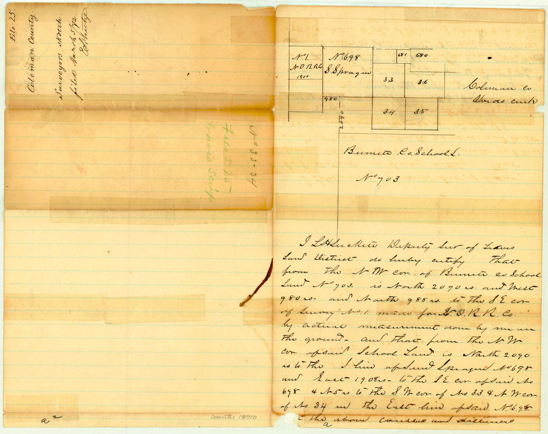
Coleman County Sketch File 25
[Sketch of area on Hord's Creek, north of Burnet County School Land]
-
Map/Doc
18710
-
Collection
General Map Collection
-
Object Dates
1872/2/28 (Creation Date)
1872/3/5 (File Date)
-
People and Organizations
L.H. Luckett (Surveyor/Engineer)
-
Counties
Coleman
-
Subjects
Surveying Sketch File
-
Height x Width
12.5 x 15.8 inches
31.8 x 40.1 cm
-
Medium
paper, manuscript
-
Features
Hords Creek
Part of: General Map Collection
Val Verde County Rolled Sketch 45

Print $20.00
- Digital $50.00
Val Verde County Rolled Sketch 45
Size 20.8 x 23.1 inches
Map/Doc 8118
Archer County Working Sketch 12

Print $20.00
- Digital $50.00
Archer County Working Sketch 12
1939
Size 11.2 x 18.7 inches
Map/Doc 67153
[Miller Day Ranch]
![81517, [Miller Day Ranch], General Map Collection](https://historictexasmaps.com/wmedia_w700/maps/81517.tif.jpg)
Print $40.00
- Digital $50.00
[Miller Day Ranch]
1995
Size 60.6 x 38.0 inches
Map/Doc 81517
Montgomery County Working Sketch 15

Print $40.00
- Digital $50.00
Montgomery County Working Sketch 15
1934
Size 51.8 x 41.6 inches
Map/Doc 71122
Crane County Working Sketch 17

Print $40.00
- Digital $50.00
Crane County Working Sketch 17
1957
Size 121.8 x 50.0 inches
Map/Doc 68294
Navarro County Sketch File 6

Print $6.00
- Digital $50.00
Navarro County Sketch File 6
1849
Size 6.2 x 8.4 inches
Map/Doc 32310
Culberson County Rolled Sketch 54

Print $40.00
- Digital $50.00
Culberson County Rolled Sketch 54
1968
Size 59.0 x 29.4 inches
Map/Doc 10300
Shelby County Working Sketch 20

Print $20.00
- Digital $50.00
Shelby County Working Sketch 20
1970
Size 28.0 x 22.8 inches
Map/Doc 63873
Current Miscellaneous File 103

Print $4.00
- Digital $50.00
Current Miscellaneous File 103
1840
Size 11.2 x 8.8 inches
Map/Doc 74675
Williamson County Rolled Sketch 11

Print $20.00
- Digital $50.00
Williamson County Rolled Sketch 11
Size 37.5 x 28.4 inches
Map/Doc 8268
Dallam County Working Sketch 2

Print $20.00
- Digital $50.00
Dallam County Working Sketch 2
1906
Size 38.5 x 24.1 inches
Map/Doc 68587

You may also like
Map of the Passo Cavallo on the entrance into Matagorda Bay from the Gulf of Mexico

Print $20.00
- Digital $50.00
Map of the Passo Cavallo on the entrance into Matagorda Bay from the Gulf of Mexico
1853
Size 17.8 x 27.3 inches
Map/Doc 73012
[Jesse Folk and Surrounding Surveys]
![91087, [Jesse Folk and Surrounding Surveys], Twichell Survey Records](https://historictexasmaps.com/wmedia_w700/maps/91087-1.tif.jpg)
Print $20.00
- Digital $50.00
[Jesse Folk and Surrounding Surveys]
1922
Size 21.8 x 33.7 inches
Map/Doc 91087
Throckmorton County Boundary File 3

Print $40.00
- Digital $50.00
Throckmorton County Boundary File 3
Size 18.9 x 17.9 inches
Map/Doc 59281
Hutchinson County Rolled Sketch 44-14

Print $20.00
- Digital $50.00
Hutchinson County Rolled Sketch 44-14
2002
Size 24.0 x 36.0 inches
Map/Doc 77550
Kerr County Working Sketch 4

Print $20.00
- Digital $50.00
Kerr County Working Sketch 4
1946
Size 37.6 x 26.2 inches
Map/Doc 70035
Chambers County Rolled Sketch CL

Print $40.00
- Digital $50.00
Chambers County Rolled Sketch CL
1909
Size 56.2 x 21.0 inches
Map/Doc 8610
[Travis District]
![88740, [Travis District], General Map Collection](https://historictexasmaps.com/wmedia_w700/maps/88740.tif.jpg)
Print $40.00
- Digital $50.00
[Travis District]
1840
Size 54.7 x 46.0 inches
Map/Doc 88740
Texas City Channel, Texas, Channel and Turning Basin Dredging - Sheet 6

Print $20.00
- Digital $50.00
Texas City Channel, Texas, Channel and Turning Basin Dredging - Sheet 6
1958
Size 28.6 x 40.6 inches
Map/Doc 61836
Flight Mission No. CGI-3N, Frame 106, Cameron County

Print $20.00
- Digital $50.00
Flight Mission No. CGI-3N, Frame 106, Cameron County
1954
Size 18.5 x 22.2 inches
Map/Doc 84586
Dickens County Sketch File 1

Print $20.00
- Digital $50.00
Dickens County Sketch File 1
1879
Size 18.2 x 15.5 inches
Map/Doc 11315
[Surveys along the Little River]
![76048, [Surveys along the Little River], General Map Collection](https://historictexasmaps.com/wmedia_w700/maps/76048.tif.jpg)
Print $2.00
- Digital $50.00
[Surveys along the Little River]
1846
Size 10.6 x 7.8 inches
Map/Doc 76048
[Map of Block KS in Oldham County, Texas]
![90691, [Map of Block KS in Oldham County, Texas], Twichell Survey Records](https://historictexasmaps.com/wmedia_w700/maps/90691-1.tif.jpg)
Print $20.00
- Digital $50.00
[Map of Block KS in Oldham County, Texas]
1903
Size 20.6 x 23.2 inches
Map/Doc 90691