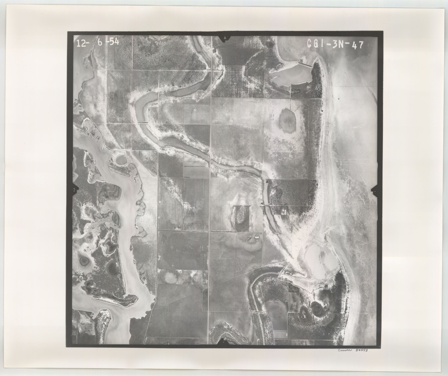
Flight Mission No. CGI-3N, Frame 47, Cameron County
CGI-3N-47
-
Map/Doc
84553
-
Collection
General Map Collection
-
Object Dates
1954/12/6 (Creation Date)
-
People and Organizations
U. S. Department of Agriculture (Publisher)
-
Counties
Cameron
-
Subjects
Aerial Photograph
-
Height x Width
18.7 x 22.3 inches
47.5 x 56.6 cm
-
Comments
Flown by Puckett Aerial Surveys, Inc. of Jackson, Mississippi.
Part of: General Map Collection
Caldwell County Working Sketch 6

Print $20.00
- Digital $50.00
Caldwell County Working Sketch 6
1958
Size 21.8 x 26.3 inches
Map/Doc 67836
Reagan County Sketch File 3

Print $20.00
- Digital $50.00
Reagan County Sketch File 3
Size 18.0 x 21.9 inches
Map/Doc 12213
Johnson County Sketch File 14a

Print $6.00
- Digital $50.00
Johnson County Sketch File 14a
1862
Size 8.0 x 11.1 inches
Map/Doc 28452
Map of La Salle County

Print $20.00
- Digital $50.00
Map of La Salle County
1877
Size 29.8 x 21.1 inches
Map/Doc 3797

Lay's Map of the United States

Print $40.00
- Digital $50.00
Lay's Map of the United States
Size 55.0 x 61.7 inches
Map/Doc 95693
Flight Mission No. DAG-2T, Frame 101, Matagorda County

Print $20.00
- Digital $50.00
Flight Mission No. DAG-2T, Frame 101, Matagorda County
1957
Size 18.6 x 18.3 inches
Map/Doc 86444
Hood County Sketch File 23a

Print $20.00
- Digital $50.00
Hood County Sketch File 23a
1887
Size 17.2 x 16.5 inches
Map/Doc 11781
Matagorda County Sketch File 3

Print $4.00
- Digital $50.00
Matagorda County Sketch File 3
1876
Size 12.9 x 8.0 inches
Map/Doc 30732
Marion County Working Sketch 1

Print $20.00
- Digital $50.00
Marion County Working Sketch 1
Size 15.2 x 23.3 inches
Map/Doc 70776
Newton County Working Sketch Graphic Index

Print $20.00
- Digital $50.00
Newton County Working Sketch Graphic Index
1946
Size 47.5 x 41.0 inches
Map/Doc 76653
Schleicher County Working Sketch 6

Print $20.00
- Digital $50.00
Schleicher County Working Sketch 6
1917
Size 24.6 x 19.3 inches
Map/Doc 63808
You may also like
Fort Bend County Sketch File 32

Print $6.00
- Digital $50.00
Fort Bend County Sketch File 32
1957
Size 14.2 x 8.7 inches
Map/Doc 23002
Hays County State Real Property Sketch 3

Print $20.00
- Digital $50.00
Hays County State Real Property Sketch 3
2003
Size 24.0 x 37.2 inches
Map/Doc 96638
Hemphill County Working Sketch 26

Print $40.00
- Digital $50.00
Hemphill County Working Sketch 26
1974
Size 57.2 x 48.3 inches
Map/Doc 66121
Jacob Kuechler's Field Notes (Field Book), Texas & Pacific Ry. Co. 80 Mile Reserve

Print $222.00
- Digital $50.00
Jacob Kuechler's Field Notes (Field Book), Texas & Pacific Ry. Co. 80 Mile Reserve
1879
Size 7.9 x 5.4 inches
Map/Doc 3050
[Atlas D, Table of Contents]
![78350, [Atlas D, Table of Contents], General Map Collection](https://historictexasmaps.com/wmedia_w700/maps/78350.tif.jpg)
Print $20.00
- Digital $50.00
[Atlas D, Table of Contents]
Size 18.3 x 9.5 inches
Map/Doc 78350
Flight Mission No. BRA-8M, Frame 78, Jefferson County

Print $20.00
- Digital $50.00
Flight Mission No. BRA-8M, Frame 78, Jefferson County
1953
Size 15.9 x 15.8 inches
Map/Doc 85598
Galveston Bay Entrance - Galveston and Texas City Harbors

Print $40.00
- Digital $50.00
Galveston Bay Entrance - Galveston and Texas City Harbors
Size 38.3 x 54.8 inches
Map/Doc 78271
Borden County Boundary File 4

Print $2.00
- Digital $50.00
Borden County Boundary File 4
Size 13.3 x 8.3 inches
Map/Doc 50636
Jones County Rolled Sketch 4

Print $20.00
- Digital $50.00
Jones County Rolled Sketch 4
2022
Size 31.9 x 24.0 inches
Map/Doc 97150
Copy of Surveyor's Field Book, Morris Browning - In Blocks 7, 5 & 4, I&GNRRCo., Hutchinson and Carson Counties, Texas

Print $2.00
- Digital $50.00
Copy of Surveyor's Field Book, Morris Browning - In Blocks 7, 5 & 4, I&GNRRCo., Hutchinson and Carson Counties, Texas
1888
Size 6.9 x 8.8 inches
Map/Doc 62275
Flight Mission No. DIX-5P, Frame 142, Aransas County

Print $20.00
- Digital $50.00
Flight Mission No. DIX-5P, Frame 142, Aransas County
1956
Size 18.0 x 18.0 inches
Map/Doc 83803
Flight Mission No. BQR-7K, Frame 25, Brazoria County

Print $20.00
- Digital $50.00
Flight Mission No. BQR-7K, Frame 25, Brazoria County
1952
Size 18.8 x 22.3 inches
Map/Doc 84023