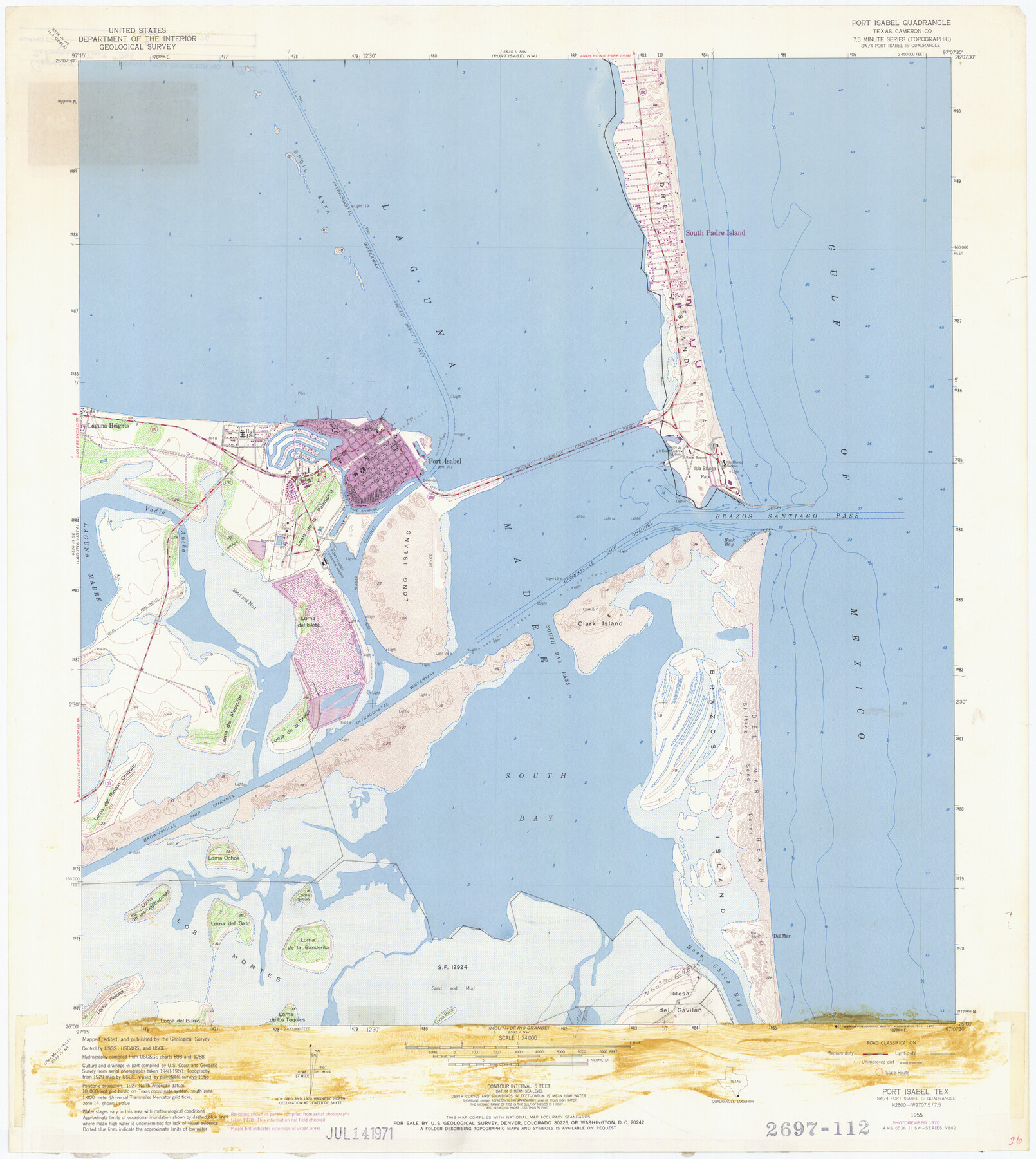
Cameron County Rolled Sketch 19
Port Isabel Quadrangle
-
Map/Doc
5388
-
Collection
General Map Collection
-
Object Dates
1976/1/20 (File Date)
1970 (Revision Date)
-
People and Organizations
United States Geological Survey (Publisher)
-
Counties
Cameron
-
Subjects
Surveying Rolled Sketch
-
Height x Width
27.1 x 24.3 inches
68.8 x 61.7 cm
-
Medium
paper, etching/engraving/lithograph
Part of: General Map Collection
Flight Mission No. CLL-1N, Frame 109, Willacy County

Print $20.00
- Digital $50.00
Flight Mission No. CLL-1N, Frame 109, Willacy County
1954
Size 18.3 x 22.1 inches
Map/Doc 87043
Galveston County Sketch File 42

Print $20.00
- Digital $50.00
Galveston County Sketch File 42
1899
Size 23.9 x 23.7 inches
Map/Doc 11538

Terry County Boundary File 4a

Print $70.00
- Digital $50.00
Terry County Boundary File 4a
Size 11.4 x 8.8 inches
Map/Doc 59249
Bosque County, Texas School Map

Print $20.00
- Digital $50.00
Bosque County, Texas School Map
1932
Size 40.9 x 36.6 inches
Map/Doc 81918
Mason County Boundary File 5

Print $20.00
- Digital $50.00
Mason County Boundary File 5
Size 9.7 x 7.0 inches
Map/Doc 56862
Val Verde County Rolled Sketch 59

Print $20.00
- Digital $50.00
Val Verde County Rolled Sketch 59
1947
Size 45.2 x 23.6 inches
Map/Doc 10078
Hardin County Working Sketch 39, part 2

Print $40.00
- Digital $50.00
Hardin County Working Sketch 39, part 2
1985
Size 36.0 x 48.5 inches
Map/Doc 63438

Travis County Sketch File 69

Print $6.00
- Digital $50.00
Travis County Sketch File 69
1955
Size 14.3 x 8.9 inches
Map/Doc 38451
Harris County Working Sketch 123

Print $20.00
- Digital $50.00
Harris County Working Sketch 123
1993
Size 19.5 x 17.0 inches
Map/Doc 66015
Hudspeth County Sketch File 22

Print $10.00
- Digital $50.00
Hudspeth County Sketch File 22
1935
Size 11.2 x 8.7 inches
Map/Doc 26974
You may also like
Frio County Rolled Sketch 7

Print $20.00
- Digital $50.00
Frio County Rolled Sketch 7
Size 21.0 x 17.4 inches
Map/Doc 5918
Flight Mission No. DCL-7C, Frame 70, Kenedy County

Print $20.00
- Digital $50.00
Flight Mission No. DCL-7C, Frame 70, Kenedy County
1943
Size 15.4 x 15.3 inches
Map/Doc 86056
[H. & G. N. RR. Co. Block 1]
![90889, [H. & G. N. RR. Co. Block 1], Twichell Survey Records](https://historictexasmaps.com/wmedia_w700/maps/90889-1.tif.jpg)
Print $20.00
- Digital $50.00
[H. & G. N. RR. Co. Block 1]
Size 16.5 x 27.9 inches
Map/Doc 90889
Duval County Sketch File 74

Print $42.00
- Digital $50.00
Duval County Sketch File 74
Size 10.1 x 8.8 inches
Map/Doc 21465
Upshur County Boundary File 1

Print $30.00
- Digital $50.00
Upshur County Boundary File 1
Size 9.4 x 8.6 inches
Map/Doc 59500
Edwards County Sketch File 49

Print $20.00
- Digital $50.00
Edwards County Sketch File 49
1958
Size 25.6 x 27.9 inches
Map/Doc 11444
Bell County Sketch File 27

Print $4.00
- Digital $50.00
Bell County Sketch File 27
1870
Size 8.9 x 9.4 inches
Map/Doc 14435
Williamson County Boundary File 5

Print $233.00
- Digital $50.00
Williamson County Boundary File 5
Size 14.4 x 8.8 inches
Map/Doc 60023
Chambers County Sketch File 58

Print $2.00
- Digital $50.00
Chambers County Sketch File 58
1995
Size 9.1 x 14.7 inches
Map/Doc 18108
Edwards County Boundary File 27a

Print $14.00
- Digital $50.00
Edwards County Boundary File 27a
Size 12.7 x 8.4 inches
Map/Doc 52880
Shelby County Working Sketch 15

Print $20.00
- Digital $50.00
Shelby County Working Sketch 15
1952
Size 24.5 x 19.2 inches
Map/Doc 63868
General Highway Map, Johnson County, Texas

Print $20.00
General Highway Map, Johnson County, Texas
1940
Size 18.3 x 24.8 inches
Map/Doc 79149