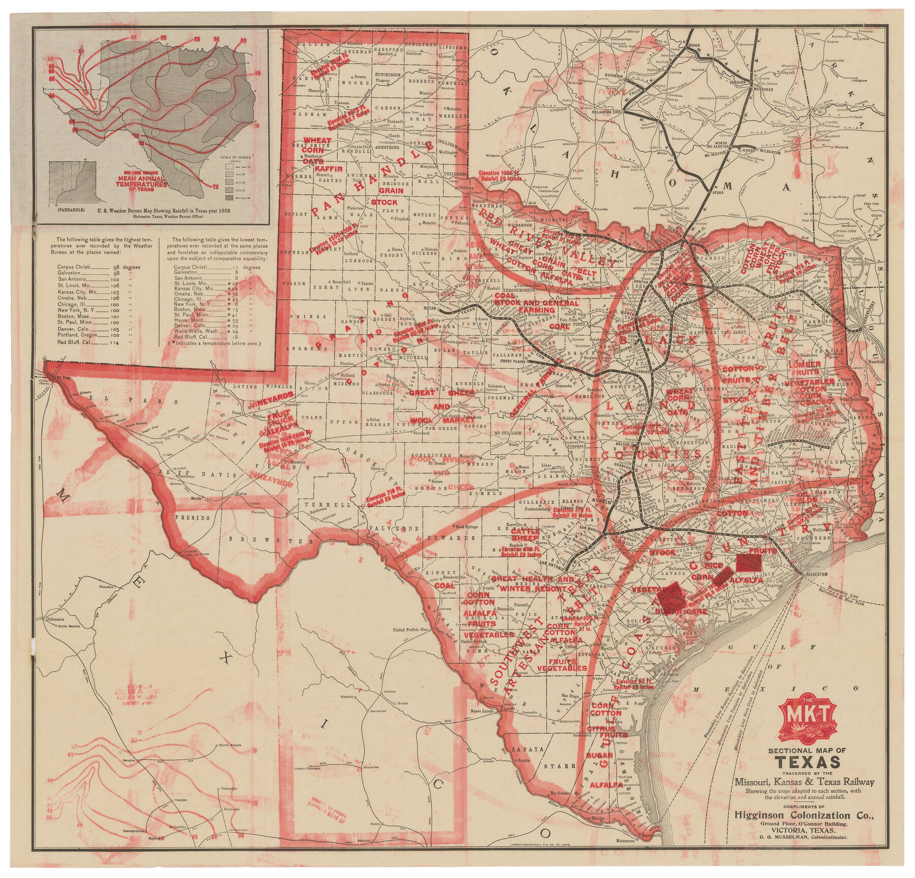
Sectional map of Texas traversed by the Missouri, Kansas & Texas Railway, showing the crops adapted to each section, with the elevation and annual rainfall
The Reason Why
-
Map/Doc
95816
-
Collection
Cobb Digital Map Collection
-
Object Dates
[1908] (Creation Date)
-
People and Organizations
Lambert-Deacon-Hull Ptg. Co. (Printer)
-
Subjects
Railroads State of Texas
-
Height x Width
22.0 x 22.9 inches
55.9 x 58.2 cm
-
Medium
digital image
-
Comments
Courtesy of John & Diana Cobb.
To view original cover in which the map was folded, click "Download PDF" link above.
Part of: Cobb Digital Map Collection
Mileage Map of the Transcontinental Trails of the United States showing best roads, road distances, principal cities

Print $20.00
- Digital $50.00
Mileage Map of the Transcontinental Trails of the United States showing best roads, road distances, principal cities
1920
Size 10.8 x 12.8 inches
Map/Doc 95899
Map of the Texas & Pacific Railway and connections

Print $20.00
- Digital $50.00
Map of the Texas & Pacific Railway and connections
1899
Size 17.9 x 36.6 inches
Map/Doc 95765
Louisiana and Texas for the Winter Tourist

Louisiana and Texas for the Winter Tourist
1911
Map/Doc 96716
[Map of Texas showing Frisco Lines]
![95796, [Map of Texas showing Frisco Lines], Cobb Digital Map Collection](https://historictexasmaps.com/wmedia_w700/maps/95796.tif.jpg)
Print $20.00
- Digital $50.00
[Map of Texas showing Frisco Lines]
1910
Size 19.8 x 19.2 inches
Map/Doc 95796
Correct Map of Texas

Print $20.00
- Digital $50.00
Correct Map of Texas
1873
Size 21.3 x 16.9 inches
Map/Doc 95776
Map of the Texas & Pacific Railway "Gould System" Lines and connections

Print $20.00
- Digital $50.00
Map of the Texas & Pacific Railway "Gould System" Lines and connections
1906
Size 17.7 x 36.6 inches
Map/Doc 95769
The Principal Transportation Lines extending west from Boston, New York, Philadelphia, and Baltimore

Print $20.00
- Digital $50.00
The Principal Transportation Lines extending west from Boston, New York, Philadelphia, and Baltimore
1881
Size 17.1 x 24.4 inches
Map/Doc 95908
The Beautiful Valley of the Lower Rio Grande

The Beautiful Valley of the Lower Rio Grande
1925
Map/Doc 96735
The Rand McNally New Commercial Atlas Map of Texas

Print $20.00
- Digital $50.00
The Rand McNally New Commercial Atlas Map of Texas
1914
Size 28.6 x 40.2 inches
Map/Doc 95849
Texas, the Empire State of the Southwest

Texas, the Empire State of the Southwest
1909
Size 9.7 x 5.4 inches
Map/Doc 96603
Map of Texas with population and location of principal towns and cities according to latest reliable statistics

Print $20.00
- Digital $50.00
Map of Texas with population and location of principal towns and cities according to latest reliable statistics
1913
Size 18.3 x 20.2 inches
Map/Doc 95879
A Geographically Correct County Map of States Traversed by the St. Louis, Iron Mountain & Southern Railway and its Connections

Print $20.00
- Digital $50.00
A Geographically Correct County Map of States Traversed by the St. Louis, Iron Mountain & Southern Railway and its Connections
1876
Size 18.6 x 15.9 inches
Map/Doc 95781
You may also like
Flight Mission No. BQR-14K, Frame 40, Brazoria County

Print $20.00
- Digital $50.00
Flight Mission No. BQR-14K, Frame 40, Brazoria County
1952
Size 18.7 x 22.3 inches
Map/Doc 84097
Blanco County Working Sketch 8

Print $20.00
- Digital $50.00
Blanco County Working Sketch 8
1925
Size 23.0 x 22.3 inches
Map/Doc 67368
Pecos County Working Sketch 13

Print $20.00
- Digital $50.00
Pecos County Working Sketch 13
1912
Size 24.2 x 35.3 inches
Map/Doc 71483
Haskell County Rolled Sketch 13

Print $3.00
- Digital $50.00
Haskell County Rolled Sketch 13
1991
Size 11.0 x 17.1 inches
Map/Doc 6171
Nueces County NRC Article 33.136 Location Key Sheet

Print $20.00
- Digital $50.00
Nueces County NRC Article 33.136 Location Key Sheet
1975
Size 27.3 x 23.0 inches
Map/Doc 88587
General Highway Map, Burnet County, Texas

Print $20.00
General Highway Map, Burnet County, Texas
1940
Size 18.4 x 25.0 inches
Map/Doc 79035
Yellowhouse Addition to Littlefield, Texas Located on Labors 12 & 13 Capitol League 664

Print $20.00
- Digital $50.00
Yellowhouse Addition to Littlefield, Texas Located on Labors 12 & 13 Capitol League 664
1925
Size 26.9 x 26.7 inches
Map/Doc 92402

[Sketch between Wheeler County and Oklahoma]
![89674, [Sketch between Wheeler County and Oklahoma], Twichell Survey Records](https://historictexasmaps.com/wmedia_w700/maps/89674-1.tif.jpg)
Print $40.00
- Digital $50.00
[Sketch between Wheeler County and Oklahoma]
Size 64.9 x 10.2 inches
Map/Doc 89674
Galveston County NRC Article 33.136 Location Key Sheet

Print $20.00
- Digital $50.00
Galveston County NRC Article 33.136 Location Key Sheet
1994
Size 27.0 x 21.8 inches
Map/Doc 77019
A New & Correct Map of the Trading Part of the West Indies, including the Seat of War between Gr. Britain and France Likewise the British Empire in America, with the French and Spanish Settlements adjacent thereto

Print $20.00
- Digital $50.00
A New & Correct Map of the Trading Part of the West Indies, including the Seat of War between Gr. Britain and France Likewise the British Empire in America, with the French and Spanish Settlements adjacent thereto
1759
Size 27.4 x 41.4 inches
Map/Doc 93826
Location of the Southern Kansas Railway of Texas, Gray County, Texas

Print $40.00
- Digital $50.00
Location of the Southern Kansas Railway of Texas, Gray County, Texas
1887
Size 19.9 x 75.3 inches
Map/Doc 64036