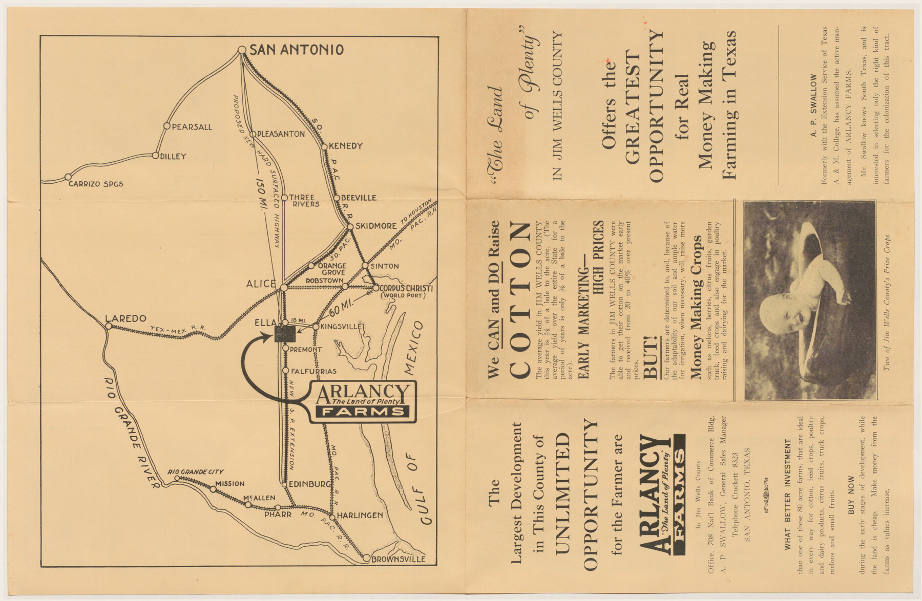
Arlancy the Land of Plenty Farms
-
Map/Doc
96737
-
Collection
Cobb Digital Map Collection
-
Object Dates
[1925 ca.] (Creation Date)
-
Counties
Jim Wells
-
Height x Width
10.9 x 16.6 inches
27.7 x 42.2 cm
-
Medium
digital image
-
Comments
Courtesy of John & Diana Cobb.
For promotional copy on verso, see 96738.
Related maps
Arlancy the Land of Plenty Farms

Print $20.00
- Digital $50.00
Arlancy the Land of Plenty Farms
1925
Size 10.8 x 16.6 inches
Map/Doc 96738
Part of: Cobb Digital Map Collection
Map of the Southern and South-western States engraved to accompany Appletons' hand book of American travel

Print $20.00
- Digital $50.00
Map of the Southern and South-western States engraved to accompany Appletons' hand book of American travel
1849
Size 13.0 x 17.8 inches
Map/Doc 95902
Geographically Correct Map of United States showing the Union Pacific System - Union Pacific R.R. Co., Oregon Short Line R.R. Co., Oregon-Washington R.R. & Nav. Co., Los Angeles & Salt Lake R.R. Co., St. Joseph & Grand Island Ry. Co. and connections

Print $20.00
- Digital $50.00
Geographically Correct Map of United States showing the Union Pacific System - Union Pacific R.R. Co., Oregon Short Line R.R. Co., Oregon-Washington R.R. & Nav. Co., Los Angeles & Salt Lake R.R. Co., St. Joseph & Grand Island Ry. Co. and connections
1922
Size 18.2 x 32.2 inches
Map/Doc 95771
Oklahoma and Indian Territory Along the Frisco

Oklahoma and Indian Territory Along the Frisco
1905
Map/Doc 96771
Texas: Her Resources and Capabilities: being a description of the State of Texas and the inducements She offers to those seeking homes in a new country

Texas: Her Resources and Capabilities: being a description of the State of Texas and the inducements She offers to those seeking homes in a new country
1881
Size 9.3 x 6.1 inches
Map/Doc 96615
"Iron Mountain Route" to all parts of Texas - I. & G. N., T. & P., Iron Mountain - "The Way to Texas"

Print $20.00
- Digital $50.00
"Iron Mountain Route" to all parts of Texas - I. & G. N., T. & P., Iron Mountain - "The Way to Texas"
1909
Size 21.8 x 24.0 inches
Map/Doc 95793
[Map of Texas]
![96624, [Map of Texas], Cobb Digital Map Collection](https://historictexasmaps.com/wmedia_w700/maps/96624.tif.jpg)
Print $20.00
- Digital $50.00
[Map of Texas]
1869
Size 9.9 x 8.8 inches
Map/Doc 96624
Points of interest in and around Brownsville

Points of interest in and around Brownsville
1933
Map/Doc 96746
The Rand McNally New Commercial Atlas Map of Texas

Print $20.00
- Digital $50.00
The Rand McNally New Commercial Atlas Map of Texas
1918
Size 28.6 x 40.2 inches
Map/Doc 95851
[Map 1:] A Geographically Correct County Map of States Traversed by the St. Louis, Iron Mountain and Southern Railway and its connections / [Map 2:] Map of the St. Louis, Iron Mountain and Southern Railway, and connections
![95784, [Map 1:] A Geographically Correct County Map of States Traversed by the St. Louis, Iron Mountain and Southern Railway and its connections / [Map 2:] Map of the St. Louis, Iron Mountain and Southern Railway, and connections, Cobb Digital Map Collection - 1](https://historictexasmaps.com/wmedia_w700/maps/95784.tif.jpg)
Print $20.00
- Digital $50.00
[Map 1:] A Geographically Correct County Map of States Traversed by the St. Louis, Iron Mountain and Southern Railway and its connections / [Map 2:] Map of the St. Louis, Iron Mountain and Southern Railway, and connections
1878
Size 18.9 x 32.2 inches
Map/Doc 95784
Panhandle of Texas

Print $20.00
- Digital $50.00
Panhandle of Texas
1907
Size 11.4 x 14.4 inches
Map/Doc 95889
[Map of North Carolina and South Carolina]
![96621, [Map of North Carolina and South Carolina], Cobb Digital Map Collection](https://historictexasmaps.com/wmedia_w700/maps/96621.tif.jpg)
Print $20.00
- Digital $50.00
[Map of North Carolina and South Carolina]
1869
Size 8.9 x 9.2 inches
Map/Doc 96621
Map of the Texas & Pacific Railway and connections

Print $20.00
- Digital $50.00
Map of the Texas & Pacific Railway and connections
1903
Size 17.9 x 36.6 inches
Map/Doc 95767
You may also like
[Sketch for Mineral Application 13271- Trinity River]
![65628, [Sketch for Mineral Application 13271- Trinity River], General Map Collection](https://historictexasmaps.com/wmedia_w700/maps/65628.tif.jpg)
Print $40.00
- Digital $50.00
[Sketch for Mineral Application 13271- Trinity River]
1925
Size 63.1 x 22.4 inches
Map/Doc 65628
Flight Mission No. DQN-7K, Frame 37, Calhoun County

Print $20.00
- Digital $50.00
Flight Mission No. DQN-7K, Frame 37, Calhoun County
1953
Size 18.4 x 22.1 inches
Map/Doc 84475
[Parts of Blocks M-20, 22 and S]
![91825, [Parts of Blocks M-20, 22 and S], Twichell Survey Records](https://historictexasmaps.com/wmedia_w700/maps/91825-1.tif.jpg)
Print $20.00
- Digital $50.00
[Parts of Blocks M-20, 22 and S]
1921
Size 23.3 x 18.3 inches
Map/Doc 91825
Free & Williams Subdivision of the north half of Outlots 56 and 57

Print $20.00
- Digital $50.00
Free & Williams Subdivision of the north half of Outlots 56 and 57
Size 10.9 x 29.5 inches
Map/Doc 475
Angelina County Working Sketch 22a

Print $20.00
- Digital $50.00
Angelina County Working Sketch 22a
1953
Size 22.3 x 20.1 inches
Map/Doc 67103
Duval County Rolled Sketch 41

Print $20.00
- Digital $50.00
Duval County Rolled Sketch 41
1966
Size 23.3 x 21.1 inches
Map/Doc 5758
Presidio County Sketch File 30

Print $10.00
- Digital $50.00
Presidio County Sketch File 30
1890
Size 10.3 x 8.1 inches
Map/Doc 34468

Right of Way and Track Map Houston & Texas Central R.R. operated by the T. & N.O. R.R. Co., Austin Branch

Print $40.00
- Digital $50.00
Right of Way and Track Map Houston & Texas Central R.R. operated by the T. & N.O. R.R. Co., Austin Branch
1918
Size 25.8 x 57.8 inches
Map/Doc 64558
[Townships 1 through 5 North, Blocks 34, 35, and 36]
![92587, [Townships 1 through 5 North, Blocks 34, 35, and 36], Twichell Survey Records](https://historictexasmaps.com/wmedia_w700/maps/92587-1.tif.jpg)
Print $20.00
- Digital $50.00
[Townships 1 through 5 North, Blocks 34, 35, and 36]
Size 41.7 x 21.4 inches
Map/Doc 92587
Right of Way and Track Map, International & Gt. Northern Ry. Operated by the International & Gt. Northern Ry. Co., Gulf Division

Print $40.00
- Digital $50.00
Right of Way and Track Map, International & Gt. Northern Ry. Operated by the International & Gt. Northern Ry. Co., Gulf Division
1917
Size 24.8 x 57.0 inches
Map/Doc 64245
Hutchinson County Rolled Sketch 44-10

Print $20.00
- Digital $50.00
Hutchinson County Rolled Sketch 44-10
2002
Size 24.0 x 36.0 inches
Map/Doc 77546