Briscoe County Sketch File A-1
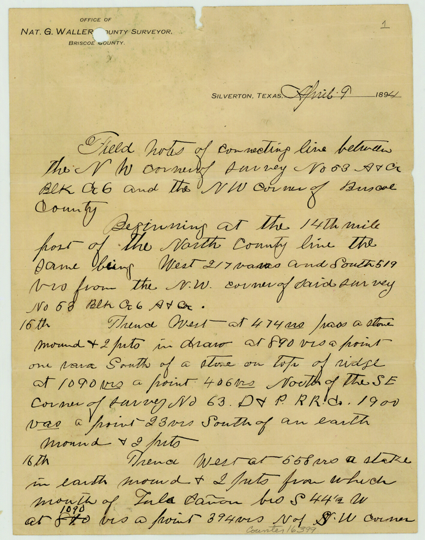
[Field notes of connecting line between the NW corner of survey no. 53, Block G-6 and the NW corner of Briscoe County]
-
Map/Doc
16399
-
Collection
General Map Collection
-
Object Dates
1894/4/9 (Creation Date)
1894/5/26 (File Date)
-
People and Organizations
Nat G. Waller (Surveyor/Engineer)
-
Counties
Armstrong Briscoe Swisher
-
Subjects
Surveying Sketch File
-
Height x Width
10.7 x 8.4 inches
27.2 x 21.3 cm
-
Medium
paper, manuscript
-
Comments
See Briscoe County Sketch File A (10997) for sketch.
-
Features
Tula Canon
Campbell Creek
Bull Run [Creek]
Red River
Turkey Creek
Armstrong Creek
Related maps
Briscoe County Sketch File A

Print $40.00
- Digital $50.00
Briscoe County Sketch File A
1894
Size 17.3 x 21.1 inches
Map/Doc 10997
Part of: General Map Collection
Travis County Sketch File 56

Print $6.00
- Digital $50.00
Travis County Sketch File 56
1945
Size 14.2 x 9.0 inches
Map/Doc 38398

Trinity River, Cooks Ferry Sheet

Print $40.00
- Digital $50.00
Trinity River, Cooks Ferry Sheet
1926
Size 36.5 x 56.2 inches
Map/Doc 65215
[Sketch for Mineral Application 19560 - 19588 - San Bernard River]
![65662, [Sketch for Mineral Application 19560 - 19588 - San Bernard River], General Map Collection](https://historictexasmaps.com/wmedia_w700/maps/65662.tif.jpg)
Print $40.00
- Digital $50.00
[Sketch for Mineral Application 19560 - 19588 - San Bernard River]
Size 31.6 x 73.6 inches
Map/Doc 65662
Houston & Texas Central Railway Through Bastrop County

Print $20.00
- Digital $50.00
Houston & Texas Central Railway Through Bastrop County
1916
Size 21.3 x 41.6 inches
Map/Doc 64419
Stephens County Working Sketch 27

Print $20.00
- Digital $50.00
Stephens County Working Sketch 27
1976
Size 34.4 x 32.3 inches
Map/Doc 63970

Map of Moser Ranch, Bowie County, Texas

Print $20.00
- Digital $50.00
Map of Moser Ranch, Bowie County, Texas
Size 29.0 x 27.4 inches
Map/Doc 73558
Morris County Rolled Sketch 2A

Print $20.00
- Digital $50.00
Morris County Rolled Sketch 2A
Size 24.0 x 18.8 inches
Map/Doc 10228
Galveston Bay Entrance - Galveston and Texas City Harbors

Print $40.00
- Digital $50.00
Galveston Bay Entrance - Galveston and Texas City Harbors
1971
Size 33.4 x 50.1 inches
Map/Doc 69861
Polk County Working Sketch 21

Print $20.00
- Digital $50.00
Polk County Working Sketch 21
1953
Size 22.6 x 24.2 inches
Map/Doc 71636
Montgomery County Working Sketch 73

Print $20.00
- Digital $50.00
Montgomery County Working Sketch 73
1980
Size 19.5 x 42.9 inches
Map/Doc 71180
You may also like
Blanco County Working Sketch 5

Print $20.00
- Digital $50.00
Blanco County Working Sketch 5
1941
Size 38.3 x 28.4 inches
Map/Doc 67364
Leon County Rolled Sketch 22

Print $20.00
- Digital $50.00
Leon County Rolled Sketch 22
1983
Size 29.9 x 27.1 inches
Map/Doc 6608
Matagorda County Rolled Sketch 34

Print $20.00
- Digital $50.00
Matagorda County Rolled Sketch 34
Size 25.4 x 40.5 inches
Map/Doc 6695
[S.P.R.R.Co. Blocks 15 &16]
![92355, [S.P.R.R.Co. Blocks 15 &16], Twichell Survey Records](https://historictexasmaps.com/wmedia_w700/maps/92355-1.tif.jpg)
Print $20.00
- Digital $50.00
[S.P.R.R.Co. Blocks 15 &16]
Size 37.3 x 32.3 inches
Map/Doc 92355
[J. Poitevent Block 2, T. T. RR. Block 2, C. C. Slaughter Block 1]
![90619, [J. Poitevent Block 2, T. T. RR. Block 2, C. C. Slaughter Block 1], Twichell Survey Records](https://historictexasmaps.com/wmedia_w700/maps/90619-1.tif.jpg)
Print $2.00
- Digital $50.00
[J. Poitevent Block 2, T. T. RR. Block 2, C. C. Slaughter Block 1]
Size 9.1 x 11.7 inches
Map/Doc 90619
Henderson County Sketch File 17

Print $40.00
- Digital $50.00
Henderson County Sketch File 17
Size 14.2 x 14.6 inches
Map/Doc 26361
Limestone County Working Sketch 21

Print $20.00
- Digital $50.00
Limestone County Working Sketch 21
1979
Size 29.4 x 38.7 inches
Map/Doc 70571
Map of Clay County

Print $20.00
- Digital $50.00
Map of Clay County
1883
Size 26.0 x 23.3 inches
Map/Doc 3396
Childress County Rolled Sketch 4

Print $20.00
- Digital $50.00
Childress County Rolled Sketch 4
1891
Size 18.8 x 42.2 inches
Map/Doc 5438
Milam County Sketch File 5

Print $4.00
- Digital $50.00
Milam County Sketch File 5
1901
Size 14.2 x 8.7 inches
Map/Doc 31632
Hardin County Working Sketch 24

Print $20.00
- Digital $50.00
Hardin County Working Sketch 24
1950
Size 15.3 x 11.9 inches
Map/Doc 63422
Rail Road Map of Pennsylvania

Print $40.00
- Digital $50.00
Rail Road Map of Pennsylvania
1893
Size 38.4 x 58.1 inches
Map/Doc 97108