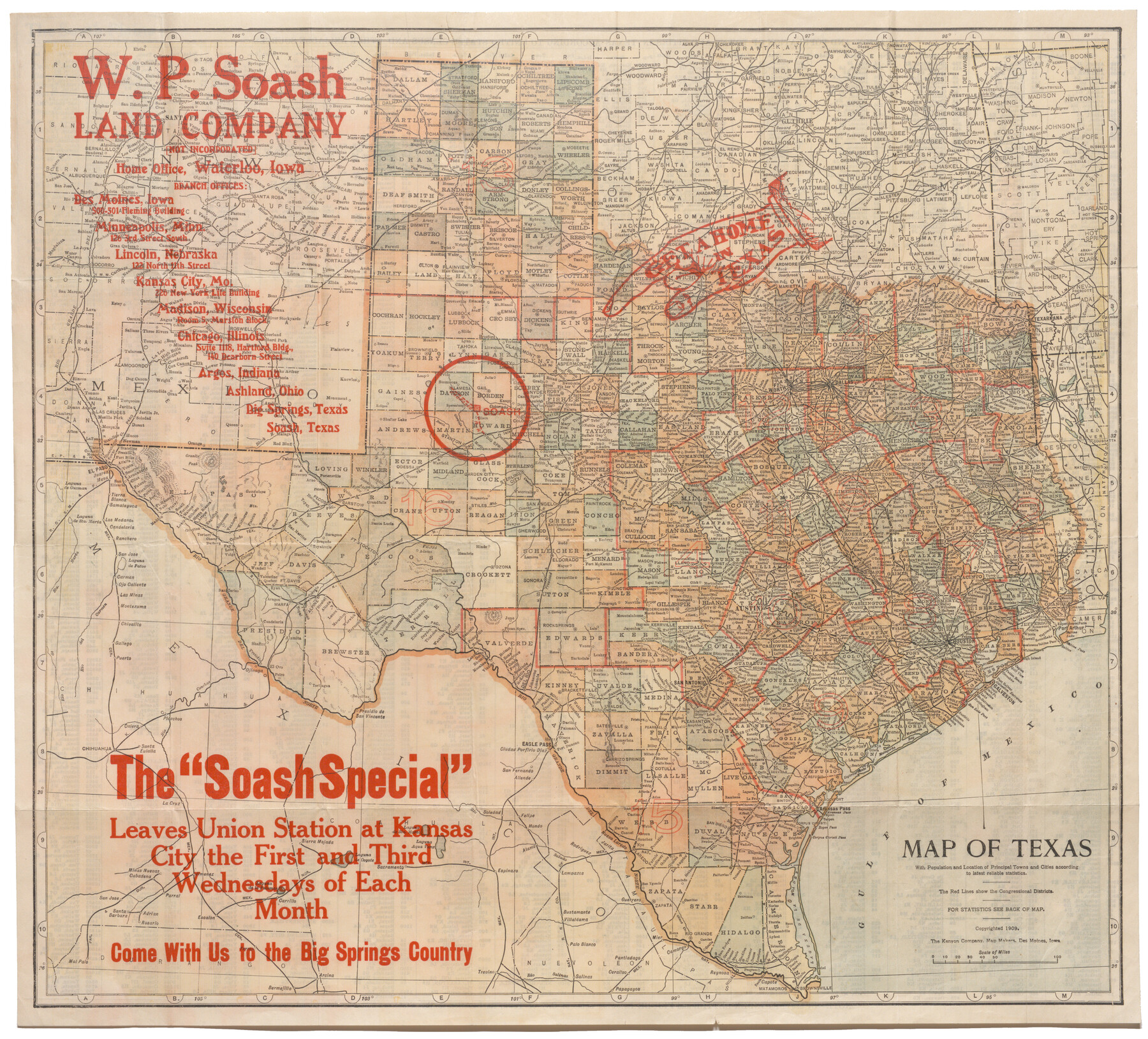
Map of Texas with population and location of principal towns and cities according to latest reliable statistics
-
Map/Doc
95874
-
Collection
Cobb Digital Map Collection
-
Object Dates
1909 (Creation Date)
-
People and Organizations
The Kenyon Company (Publisher)
The Kenyon Company (Printer)
-
Subjects
Railroads State of Texas
-
Height x Width
18.3 x 20.2 inches
46.5 x 51.3 cm
-
Medium
digital image
-
Comments
Map branded by W.P. Soash Land Company.
Courtesy of John & Diana Cobb.
To view statistics printed on verso and original cover in which this map was folded, click "Download PDF" link above.
Part of: Cobb Digital Map Collection
Under Sapphire Skies San Antonio

Under Sapphire Skies San Antonio
1928
Size 9.4 x 6.4 inches
Map/Doc 97043
Map of the Texas & Pacific Railway and connections

Print $20.00
- Digital $50.00
Map of the Texas & Pacific Railway and connections
1899
Size 17.9 x 36.6 inches
Map/Doc 95765
Land fur Federmann und eine Heimath fur Heimathlose!

Land fur Federmann und eine Heimath fur Heimathlose!
1901
Map/Doc 96749

Phelps's National Map of the United States, a Travellers Guide. Embracing the principal railroads, canals, steamboat & stage routes, throughout the Union

Print $20.00
- Digital $50.00
Phelps's National Map of the United States, a Travellers Guide. Embracing the principal railroads, canals, steamboat & stage routes, throughout the Union
1849
Size 20.9 x 26.3 inches
Map/Doc 95901
The MKT - Texas Empire of the South

Print $20.00
- Digital $50.00
The MKT - Texas Empire of the South
1905
Size 18.5 x 40.6 inches
Map/Doc 97035
Map of the Lower Rio Grande Valley showing Alamo-Donna Farms

Print $20.00
- Digital $50.00
Map of the Lower Rio Grande Valley showing Alamo-Donna Farms
1920
Size 14.0 x 13.4 inches
Map/Doc 95801


A New and Correct County Map of the State of Texas

Print $20.00
- Digital $50.00
A New and Correct County Map of the State of Texas
1891
Size 22.4 x 27.3 inches
Map/Doc 95760
Oklahoma and Indian Territory Along the Frisco

Oklahoma and Indian Territory Along the Frisco
1905
Map/Doc 96771
Texas, the Empire State of the Southwest

Texas, the Empire State of the Southwest
1909
Size 9.7 x 5.4 inches
Map/Doc 96603
You may also like
Right of Way and Track Map, the Missouri, Kansas and Texas Ry. of Texas - Henrietta Division

Print $20.00
- Digital $50.00
Right of Way and Track Map, the Missouri, Kansas and Texas Ry. of Texas - Henrietta Division
1918
Size 11.7 x 26.9 inches
Map/Doc 64749
[Mrs. May Vinson Survey]
![91919, [Mrs. May Vinson Survey], Twichell Survey Records](https://historictexasmaps.com/wmedia_w700/maps/91919-1.tif.jpg)
Print $20.00
- Digital $50.00
[Mrs. May Vinson Survey]
Size 32.8 x 14.9 inches
Map/Doc 91919
[Blocks B-19, B-29, 34 and 5]
![91846, [Blocks B-19, B-29, 34 and 5], Twichell Survey Records](https://historictexasmaps.com/wmedia_w700/maps/91846-1.tif.jpg)
Print $20.00
- Digital $50.00
[Blocks B-19, B-29, 34 and 5]
1902
Size 12.2 x 16.4 inches
Map/Doc 91846
Irion County Rolled Sketch 22

Print $20.00
- Digital $50.00
Irion County Rolled Sketch 22
1936
Size 24.3 x 39.9 inches
Map/Doc 6330
Bee County Working Sketch 29b

Print $20.00
- Digital $50.00
Bee County Working Sketch 29b
1988
Size 34.4 x 36.3 inches
Map/Doc 67280
Crockett County Sketch File 26

Print $58.00
- Digital $50.00
Crockett County Sketch File 26
1880
Size 8.7 x 7.2 inches
Map/Doc 19706
General Highway Map Burnet County, Texas

Print $20.00
- Digital $50.00
General Highway Map Burnet County, Texas
1953
Size 25.8 x 18.7 inches
Map/Doc 92470
Packery Channel

Print $20.00
- Digital $50.00
Packery Channel
1950
Size 17.2 x 17.1 inches
Map/Doc 2996
Upshur County Rolled Sketch 3

Print $20.00
- Digital $50.00
Upshur County Rolled Sketch 3
1965
Size 35.3 x 30.0 inches
Map/Doc 8062
The Peters Colony. January 20, 1843

Print $20.00
The Peters Colony. January 20, 1843
2020
Size 17.2 x 21.7 inches
Map/Doc 96365
[Block 30 - Jasper Hays]
![92949, [Block 30 - Jasper Hays], Twichell Survey Records](https://historictexasmaps.com/wmedia_w700/maps/92949-1.tif.jpg)
Print $20.00
- Digital $50.00
[Block 30 - Jasper Hays]
Size 25.8 x 17.8 inches
Map/Doc 92949
Armstrong County Boundary File 1c

Print $10.00
- Digital $50.00
Armstrong County Boundary File 1c
Size 14.1 x 8.7 inches
Map/Doc 50132