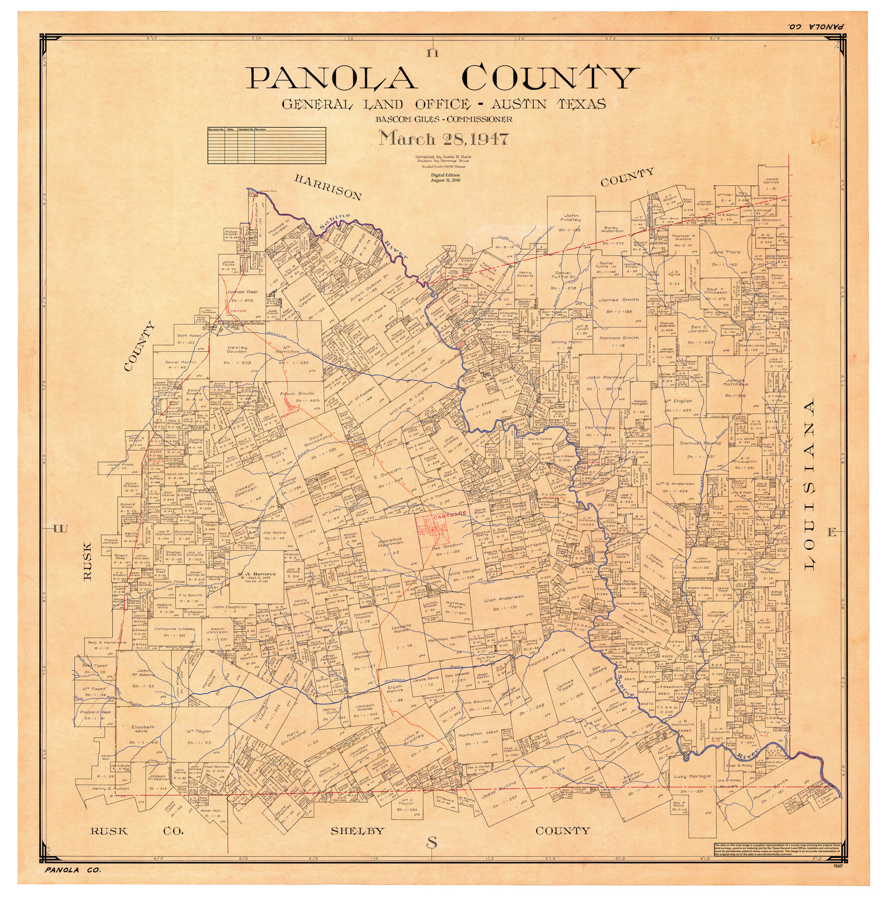
Panola County
General Land Office Official County Map
-
Map/Doc
95607
-
Collection
General Map Collection
-
Object Dates
2019/8/31 (Revision Date)
1947/3/28 (Creation Date)
-
People and Organizations
Cheyenne Betancourt (Draftsman)
Tommye Buie (Draftsman)
Curtis R. Hale (Compiler)
Bascom Giles (GLO Commissioner)
-
Counties
Panola
-
Subjects
County OCM
-
Height x Width
41.7 x 41.3 inches
105.9 x 104.9 cm
-
Medium
digital image
-
Scale
1" = 2000 varas
Part of: General Map Collection
Titus County Sketch File 5

Print $4.00
- Digital $50.00
Titus County Sketch File 5
1853
Size 11.7 x 8.2 inches
Map/Doc 38138
San Patricio County Sketch File 41

Print $4.00
- Digital $50.00
San Patricio County Sketch File 41
1842
Size 5.2 x 8.0 inches
Map/Doc 36238
Montgomery County Sketch File 30

Print $20.00
- Digital $50.00
Montgomery County Sketch File 30
Size 37.5 x 41.7 inches
Map/Doc 10549
Hays County Sketch File 16a

Print $4.00
- Digital $50.00
Hays County Sketch File 16a
1871
Size 8.2 x 9.7 inches
Map/Doc 26229
Liberty County Working Sketch 52

Print $20.00
- Digital $50.00
Liberty County Working Sketch 52
1956
Size 32.5 x 24.6 inches
Map/Doc 70512
Newton County Sketch File 2

Print $6.00
- Digital $50.00
Newton County Sketch File 2
Size 14.0 x 10.7 inches
Map/Doc 32358
Texas-New Mexico Boundary Along Rio Grande (plats)

Print $390.00
Texas-New Mexico Boundary Along Rio Grande (plats)
1933
Map/Doc 81691
Jasper County Sketch File 10

Print $4.00
- Digital $50.00
Jasper County Sketch File 10
1878
Size 9.1 x 8.6 inches
Map/Doc 27788
Lynn County Working Sketch 3

Print $20.00
- Digital $50.00
Lynn County Working Sketch 3
1953
Size 30.8 x 30.9 inches
Map/Doc 70673
Coke County Rolled Sketch 14A

Print $20.00
- Digital $50.00
Coke County Rolled Sketch 14A
Size 21.0 x 14.1 inches
Map/Doc 5515
Zapata County Rolled Sketch 16

Print $20.00
- Digital $50.00
Zapata County Rolled Sketch 16
1940
Size 30.3 x 19.4 inches
Map/Doc 8314
Hood County Sketch File 22a

Print $5.00
- Digital $50.00
Hood County Sketch File 22a
Size 13.7 x 9.3 inches
Map/Doc 26617
You may also like
Sabine River, East Extension Merrill Lake Sheet

Print $4.00
- Digital $50.00
Sabine River, East Extension Merrill Lake Sheet
1933
Size 24.5 x 15.1 inches
Map/Doc 65141
Jack County Working Sketch 1

Print $20.00
- Digital $50.00
Jack County Working Sketch 1
Size 28.4 x 27.1 inches
Map/Doc 66427
Polk County Sketch File 18

Print $20.00
- Digital $50.00
Polk County Sketch File 18
1862
Size 25.5 x 18.9 inches
Map/Doc 12190
Blanco County Sketch File 28

Print $40.00
- Digital $50.00
Blanco County Sketch File 28
1888
Size 13.8 x 13.2 inches
Map/Doc 14623
North Sulphur River, Kinsing Sheet

Print $20.00
- Digital $50.00
North Sulphur River, Kinsing Sheet
1925
Size 30.5 x 40.8 inches
Map/Doc 65165
Real County Working Sketch 58

Print $20.00
- Digital $50.00
Real County Working Sketch 58
1962
Size 24.7 x 28.5 inches
Map/Doc 71950
El Paso County Working Sketch 23

Print $20.00
- Digital $50.00
El Paso County Working Sketch 23
1961
Size 22.3 x 28.8 inches
Map/Doc 69045
Leon County Sketch File 11a

Print $4.00
- Digital $50.00
Leon County Sketch File 11a
Size 9.7 x 8.7 inches
Map/Doc 29763
[Sketch for Mineral Applications 26885-6 - Reagan and Crockett Cos., W. H. Bland]
![3219, [Sketch for Mineral Applications 26885-6 - Reagan and Crockett Cos., W. H. Bland], General Map Collection](https://historictexasmaps.com/wmedia_w700/maps/3219-1.tif.jpg)
Print $20.00
- Digital $50.00
[Sketch for Mineral Applications 26885-6 - Reagan and Crockett Cos., W. H. Bland]
1932
Size 38.4 x 9.7 inches
Map/Doc 3219
Travis County Rolled Sketch 5

Print $20.00
- Digital $50.00
Travis County Rolled Sketch 5
1924
Size 24.1 x 27.9 inches
Map/Doc 8011
Hutchinson County

Print $20.00
- Digital $50.00
Hutchinson County
1922
Size 45.6 x 38.8 inches
Map/Doc 1863
Wilbarger County Sketch File 10

Print $20.00
- Digital $50.00
Wilbarger County Sketch File 10
1894
Size 33.9 x 38.7 inches
Map/Doc 10434