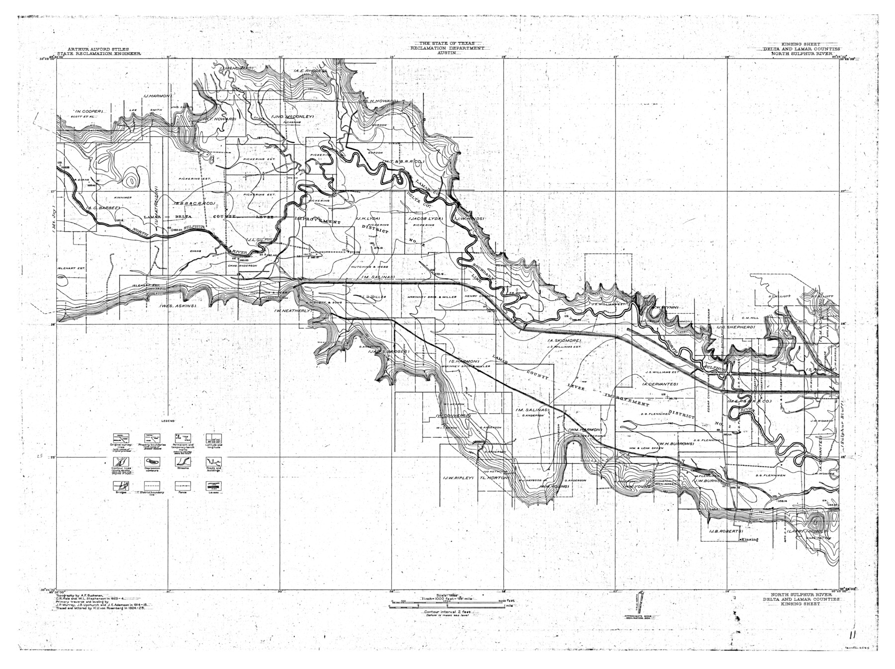
North Sulphur River, Kinsing Sheet
-
Map/Doc
65165
-
Collection
General Map Collection
-
Object Dates
1925 (Creation Date)
-
People and Organizations
Texas State Reclamation Department (Publisher)
Curtis R. Hale (Surveyor/Engineer)
H.U. von Rosenberg (Compiler)
H.U. von Rosenberg (Draftsman)
A.F. Buchanan (Surveyor/Engineer)
W.L. Stephenson (Surveyor/Engineer)
-
Counties
Delta Lamar
-
Subjects
River Surveys Topographic
-
Height x Width
30.5 x 40.8 inches
77.5 x 103.6 cm
-
Comments
Kinsing Sheet located between the Sulphur Bluff Sheet and the Mt. Joy Sheet.
Part of: General Map Collection
Fort Bend County Sketch File 6

Print $2.00
- Digital $50.00
Fort Bend County Sketch File 6
Size 4.7 x 8.4 inches
Map/Doc 22891
Comal County Sketch File 20

Print $6.00
- Digital $50.00
Comal County Sketch File 20
1857
Size 12.4 x 8.1 inches
Map/Doc 19039
Flight Mission No. BRE-2P, Frame 123, Nueces County

Print $20.00
- Digital $50.00
Flight Mission No. BRE-2P, Frame 123, Nueces County
1956
Size 18.5 x 22.4 inches
Map/Doc 86799

Southern Pacific Transportation Company Right of Way and Track Map - Main Line

Print $40.00
- Digital $50.00
Southern Pacific Transportation Company Right of Way and Track Map - Main Line
1918
Size 25.4 x 57.6 inches
Map/Doc 82858
Harrison County Working Sketch 3

Print $20.00
- Digital $50.00
Harrison County Working Sketch 3
1942
Size 43.8 x 19.0 inches
Map/Doc 66023

Lee County Working Sketch 18

Print $20.00
- Digital $50.00
Lee County Working Sketch 18
1989
Size 18.3 x 17.2 inches
Map/Doc 70397

San Patricio County Rolled Sketch 46B

Print $3.00
- Digital $50.00
San Patricio County Rolled Sketch 46B
1983
Size 12.5 x 10.0 inches
Map/Doc 8373
Palo Pinto County Rolled Sketch 12

Print $20.00
- Digital $50.00
Palo Pinto County Rolled Sketch 12
1984
Size 32.2 x 28.9 inches
Map/Doc 7192
Kinney County Sketch File 33

Print $20.00
- Digital $50.00
Kinney County Sketch File 33
1939
Size 18.1 x 22.8 inches
Map/Doc 11948
You may also like
Briscoe County Sketch File K

Print $40.00
- Digital $50.00
Briscoe County Sketch File K
1920
Size 31.9 x 21.0 inches
Map/Doc 11008
El Paso County Rolled Sketch 52

Print $20.00
- Digital $50.00
El Paso County Rolled Sketch 52
1929
Size 18.4 x 24.3 inches
Map/Doc 5839
Garza County Rolled Sketch R-2

Print $40.00
- Digital $50.00
Garza County Rolled Sketch R-2
Size 36.0 x 50.2 inches
Map/Doc 9046
Jefferson County Working Sketch 16

Print $20.00
- Digital $50.00
Jefferson County Working Sketch 16
1954
Size 31.0 x 18.8 inches
Map/Doc 66559
General Highway Map. Detail of Cities and Towns in Waller County, Texas [Hempstead and vicinity]
![79701, General Highway Map. Detail of Cities and Towns in Waller County, Texas [Hempstead and vicinity], Texas State Library and Archives](https://historictexasmaps.com/wmedia_w700/maps/79701.tif.jpg)
Print $20.00
General Highway Map. Detail of Cities and Towns in Waller County, Texas [Hempstead and vicinity]
1961
Size 24.8 x 18.2 inches
Map/Doc 79701
Wharton County Working Sketch 25

Print $20.00
- Digital $50.00
Wharton County Working Sketch 25
1993
Size 20.0 x 25.5 inches
Map/Doc 72489
Mitchell County

Print $20.00
- Digital $50.00
Mitchell County
1971
Size 39.9 x 33.3 inches
Map/Doc 77375
Wichita County

Print $20.00
- Digital $50.00
Wichita County
1971
Size 39.1 x 40.8 inches
Map/Doc 95673
Map of Wilbarger County

Print $40.00
- Digital $50.00
Map of Wilbarger County
1887
Size 52.2 x 47.0 inches
Map/Doc 16926
Flight Mission No. DAG-22K, Frame 82, Matagorda County

Print $20.00
- Digital $50.00
Flight Mission No. DAG-22K, Frame 82, Matagorda County
1953
Size 18.5 x 22.4 inches
Map/Doc 86466
Map of Asia engraved to illustrate Mitchell's school and family geography (Inset: Map of Palestine or the Holy Land)

Print $20.00
- Digital $50.00
Map of Asia engraved to illustrate Mitchell's school and family geography (Inset: Map of Palestine or the Holy Land)
1839
Size 9.5 x 11.8 inches
Map/Doc 93506
Navarro County Working Sketch 7

Print $20.00
- Digital $50.00
Navarro County Working Sketch 7
1950
Size 28.2 x 23.4 inches
Map/Doc 71237