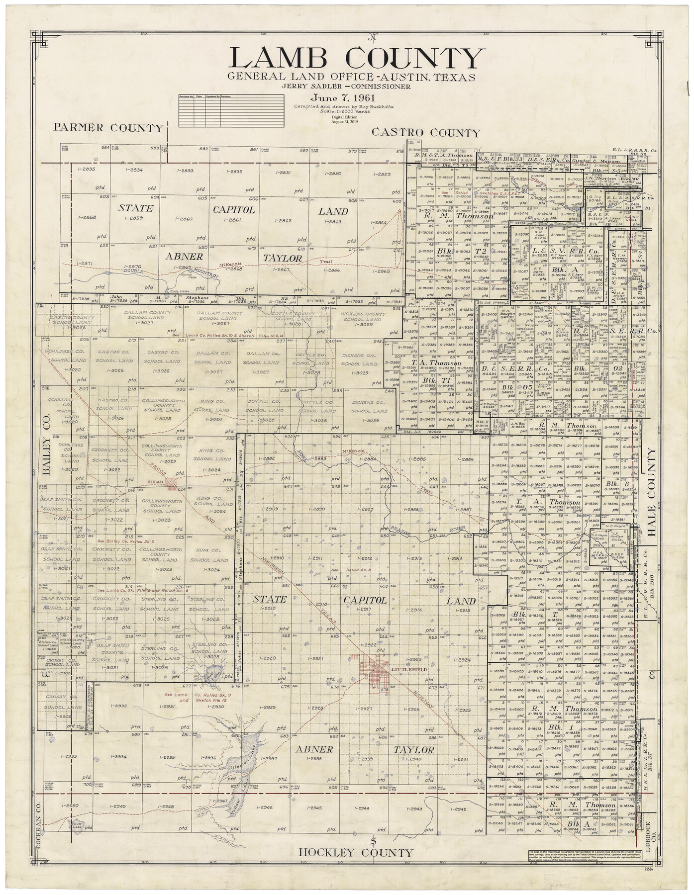
Lamb County
General Land Office Official County Map
-
Map/Doc
95564
-
Collection
General Map Collection
-
Object Dates
6/7/1961 (Creation Date)
8/31/2019 (Revision Date)
-
People and Organizations
Cheyenne Betancourt (Draftsman)
Jerry Sadler (GLO Commissioner)
Roy Buckholts (Draftsman)
Roy Buckholts (Compiler)
-
Counties
Lamb
-
Subjects
County OCM
-
Height x Width
46.7 x 36.7 inches
118.6 x 93.2 cm
-
Medium
digital image
-
Scale
1" = 2000 varas
Part of: General Map Collection
Van Zandt County Sketch File 15a

Print $4.00
- Digital $50.00
Van Zandt County Sketch File 15a
1858
Size 6.7 x 8.1 inches
Map/Doc 39406
Hamilton County Rolled Sketch 9

Print $20.00
- Digital $50.00
Hamilton County Rolled Sketch 9
1903
Size 32.8 x 30.4 inches
Map/Doc 9098
Rio Grande Rectification Project, El Paso and Juarez Valley

Print $20.00
- Digital $50.00
Rio Grande Rectification Project, El Paso and Juarez Valley
1935
Size 10.7 x 29.5 inches
Map/Doc 60869
Grimes County Working Sketch 7

Print $20.00
- Digital $50.00
Grimes County Working Sketch 7
1963
Size 27.2 x 33.0 inches
Map/Doc 63298
Sketch of surveys in Harrison & Marion Cos. Showing Caddo Lake & Subdivisions

Print $20.00
- Digital $50.00
Sketch of surveys in Harrison & Marion Cos. Showing Caddo Lake & Subdivisions
1955
Size 32.7 x 33.1 inches
Map/Doc 1928
Flight Mission No. DAG-23K, Frame 18, Matagorda County

Print $20.00
- Digital $50.00
Flight Mission No. DAG-23K, Frame 18, Matagorda County
1953
Size 18.5 x 22.2 inches
Map/Doc 86480
Matagorda Bay and Approaches

Print $20.00
- Digital $50.00
Matagorda Bay and Approaches
1957
Size 35.1 x 44.8 inches
Map/Doc 73381
Freestone County

Print $20.00
- Digital $50.00
Freestone County
1988
Size 45.8 x 42.6 inches
Map/Doc 73152
Henderson County Rolled Sketch 11

Print $20.00
- Digital $50.00
Henderson County Rolled Sketch 11
1915
Size 29.5 x 42.6 inches
Map/Doc 75947
Knox County Boundary File 3

Print $54.00
- Digital $50.00
Knox County Boundary File 3
Size 8.9 x 7.7 inches
Map/Doc 65019
Flight Mission No. CLL-1N, Frame 78, Willacy County

Print $20.00
- Digital $50.00
Flight Mission No. CLL-1N, Frame 78, Willacy County
1954
Size 18.4 x 22.1 inches
Map/Doc 87024
Newton County Sketch File 23

Print $4.00
- Digital $50.00
Newton County Sketch File 23
1855
Size 10.1 x 8.0 inches
Map/Doc 32403
You may also like
McMullen County Sketch File 14

Print $4.00
- Digital $50.00
McMullen County Sketch File 14
1876
Size 10.0 x 8.1 inches
Map/Doc 31361
New Guide to Spanish and Mexican Land Grants in South Texas

Price $15.00
New Guide to Spanish and Mexican Land Grants in South Texas
2009
Size 11.0 x 8.5 inches
Map/Doc 83388
[Map showing Gaines, Dawson, Yoakum, Terry and Lynn Counties]
![92007, [Map showing Gaines, Dawson, Yoakum, Terry and Lynn Counties], Twichell Survey Records](https://historictexasmaps.com/wmedia_w700/maps/92007-1.tif.jpg)
Print $20.00
- Digital $50.00
[Map showing Gaines, Dawson, Yoakum, Terry and Lynn Counties]
Size 24.2 x 20.7 inches
Map/Doc 92007
Duval County Sketch File 22

Print $20.00
- Digital $50.00
Duval County Sketch File 22
1880
Size 31.9 x 23.2 inches
Map/Doc 11386
Map of Chocolate Bay, west portion of West Bay & vicinity, Brazoria & Galveston Counties showing subdivision for mineral development

Print $40.00
- Digital $50.00
Map of Chocolate Bay, west portion of West Bay & vicinity, Brazoria & Galveston Counties showing subdivision for mineral development
Size 42.0 x 58.1 inches
Map/Doc 65806
North Line of Stonewall County, South Line of King County

Print $20.00
- Digital $50.00
North Line of Stonewall County, South Line of King County
1895
Size 8.0 x 41.1 inches
Map/Doc 91058
Galveston County Sketch File 1a

Print $4.00
- Digital $50.00
Galveston County Sketch File 1a
1847
Size 10.2 x 8.9 inches
Map/Doc 23344
Dimmit County Working Sketch 14

Print $20.00
- Digital $50.00
Dimmit County Working Sketch 14
1941
Size 27.4 x 30.1 inches
Map/Doc 68675
Roundabout The Nation's Capital with Descriptive Notes

Roundabout The Nation's Capital with Descriptive Notes
1956
Size 35.0 x 29.8 inches
Map/Doc 92362
Wise County Sketch File 20

Print $14.00
- Digital $50.00
Wise County Sketch File 20
1860
Size 12.8 x 7.9 inches
Map/Doc 40557
Map of Mason County

Print $20.00
- Digital $50.00
Map of Mason County
1879
Size 22.9 x 18.8 inches
Map/Doc 4593
Shelby County Sketch File 13

Print $2.00
- Digital $50.00
Shelby County Sketch File 13
1859
Size 8.2 x 12.8 inches
Map/Doc 36621