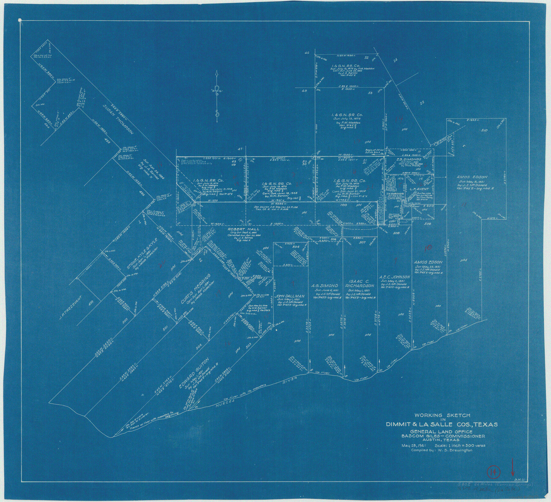
Dimmit County Working Sketch 14
-
Map/Doc
68675
-
Collection
General Map Collection
-
Object Dates
5/28/1941 (Creation Date)
-
People and Organizations
W. S. Brewington (Draftsman)
-
Counties
Dimmit La Salle
-
Subjects
Surveying Working Sketch
-
Height x Width
27.4 x 30.1 inches
69.6 x 76.5 cm
-
Scale
1" = 500 varas
Part of: General Map Collection
Flight Mission No. CRC-4R, Frame 69, Chambers County

Print $20.00
- Digital $50.00
Flight Mission No. CRC-4R, Frame 69, Chambers County
1956
Size 18.7 x 22.4 inches
Map/Doc 84873
Fort Bend County Working Sketch 4

Print $20.00
- Digital $50.00
Fort Bend County Working Sketch 4
1909
Size 23.5 x 34.8 inches
Map/Doc 69210
Kimble County Rolled Sketch 41

Print $40.00
- Digital $50.00
Kimble County Rolled Sketch 41
1994
Size 38.0 x 48.9 inches
Map/Doc 9340
Bandera County Working Sketch 60

Print $20.00
- Digital $50.00
Bandera County Working Sketch 60
2004
Size 32.1 x 43.6 inches
Map/Doc 83562
Baylor County Rolled Sketch 5

Print $20.00
- Digital $50.00
Baylor County Rolled Sketch 5
1874
Size 43.2 x 39.7 inches
Map/Doc 8444
A Topographical Map of the City of Austin

Print $20.00
- Digital $50.00
A Topographical Map of the City of Austin
1872
Size 21.0 x 14.7 inches
Map/Doc 4821
Marion County Sketch File 11

Print $4.00
- Digital $50.00
Marion County Sketch File 11
1902
Size 11.2 x 8.6 inches
Map/Doc 30581
Castro County Rolled Sketch 12

Print $20.00
- Digital $50.00
Castro County Rolled Sketch 12
1945
Size 25.7 x 15.8 inches
Map/Doc 5421
Newton County Working Sketch 34

Print $20.00
- Digital $50.00
Newton County Working Sketch 34
1959
Size 27.0 x 32.6 inches
Map/Doc 71280
Brewster County Rolled Sketch 121A

Print $40.00
- Digital $50.00
Brewster County Rolled Sketch 121A
1946
Size 37.4 x 54.5 inches
Map/Doc 8518
Flight Mission No. CUG-1P, Frame 171, Kleberg County

Print $20.00
- Digital $50.00
Flight Mission No. CUG-1P, Frame 171, Kleberg County
1956
Size 18.5 x 22.1 inches
Map/Doc 86178
Johnson County Working Sketch 11

Print $20.00
- Digital $50.00
Johnson County Working Sketch 11
1953
Size 28.7 x 22.4 inches
Map/Doc 66624
You may also like
Cameron County NRC Article 33.136 Sketch 1

Print $3.00
- Digital $50.00
Cameron County NRC Article 33.136 Sketch 1
2001
Size 11.3 x 17.4 inches
Map/Doc 61558
Brewster County Rolled Sketch 102

Print $20.00
- Digital $50.00
Brewster County Rolled Sketch 102
Size 37.0 x 43.4 inches
Map/Doc 8513
Castro County Rolled Sketch 11

Print $20.00
- Digital $50.00
Castro County Rolled Sketch 11
1940
Size 20.2 x 25.3 inches
Map/Doc 5420
McLennan County Boundary File 4a

Print $8.00
- Digital $50.00
McLennan County Boundary File 4a
Size 14.1 x 8.6 inches
Map/Doc 56979
Flight Mission No. BRA-17M, Frame 16, Jefferson County

Print $20.00
- Digital $50.00
Flight Mission No. BRA-17M, Frame 16, Jefferson County
1953
Size 18.5 x 22.3 inches
Map/Doc 85797
Robertson County Working Sketch Graphic Index

Print $20.00
- Digital $50.00
Robertson County Working Sketch Graphic Index
1945
Size 46.8 x 37.9 inches
Map/Doc 76685
Floyd County Boundary File 2

Print $53.00
- Digital $50.00
Floyd County Boundary File 2
Size 8.9 x 4.2 inches
Map/Doc 53462
Lamb County Sketch File 16

Print $4.00
- Digital $50.00
Lamb County Sketch File 16
1929
Size 11.2 x 8.8 inches
Map/Doc 29379
Hudspeth County Working Sketch 30

Print $40.00
- Digital $50.00
Hudspeth County Working Sketch 30
1972
Size 80.8 x 42.2 inches
Map/Doc 66312

Midland County Rolled Sketch 1

Print $20.00
- Digital $50.00
Midland County Rolled Sketch 1
1940
Size 32.9 x 35.0 inches
Map/Doc 9512
Medina County Rolled Sketch 23

Print $20.00
- Digital $50.00
Medina County Rolled Sketch 23
Size 30.4 x 42.6 inches
Map/Doc 89063